Pennsylvania, Bucks County, Langhorne![]()
A grave like any hole dug into the earth interrupts the natural layering of soil. For that reason, it can be distinguished as an anomaly—irregular in texture and color in comparison to undisturbed soil at that level.
Although cross-section excavation revealed no coffins, the pits contain two distinctive levels at which rusted nails occur matching the outline of the disintegrated wood boards in length and depth. Many of the pits were 3 or 4 coffins deep.
Poor preservation and time produced only traces of bone, arcs of human teeth-some of which were radiocarbon dated to this period which determined the burials with certainty.
Excavation of this location revealed 29 graves while dozens of grave features comparable to the five examined remain to be discovered.
In 1991 Woods Services, Inc. owner of this property approached the Borough with a development plan that included most of their property facing Flowers Avenue. Residents and organizations presented the Richardson Diary as evidenced that the proposed location was an unmarked soldier’s burial ground in late 1776.
Because of the Diary and the fact that the referenced house still exists, Woods Services, Inc. permitted an archaeological excavation that proved its existence as recorded in 1869. Woods Services, Inc. deeded the Burial Site to Langhorne Borough and was dedicated on Veterans Day, November 11, 1999.
Diary of Joshua Richardson
March 6, 1803-May 16, 1874
2 mo. 1st, 1869-Excerpts from page3
“… I heard my father say that his father was a sitting in our east porch and an old man came out of the hospital “opisite”, sat down beside him , he was from Boston, (the tears running down his cheeks) he had been sent for to see his son who then lay very ill with the fever, he was so near his end, he was not able to speak but appeared to know his father, he said this was the 9th son he had lost since the commencement of the war (one at home) and as soon as he was old enough he should go to (o)…:
(Inscription under the image in the middle left)
Patterns are identified across field.
(Inscription under the image in the bottom left)
Notice pit size variation. Outline of nails during horizontal analysis suggest the outline of two coffins laid side by side—others stacked straight down.
(Inscription under the image in the upper center)
Archeologist places site location after stripping topsoil.
(Inscription under the image in the middle center)
Field strategies were designed an pin flags were placed over each lector.
(Inscription under the image in the lower center)
Single grave measured during excavation.
(Inscription under the image in the lower right)
Joseph Richardson House in 1738-Collection of Historic Langhorne Association, Inc.
This project was directed by R. Michael Stewart, Ph.D., Temple University, Philadelphia PA. Recorded as one of the largest Revolutionary War Burial Sites in the Commonwealth of Pennsylvania.
(Cemeteries & Burial Sites • War, US Revolutionary) Includes location, directions, 4 photos, GPS coordinates, map.
 Marked by the
 On this field on the 21st day of December, 1866, three commissioned officers and seventy six privates of the 18th U.S. Infantry, and of the 2nd U.S. Cavalry, and four civilians, under the command of Captain Brevet-Lieutenant Colonel William J. Fetterman were killed by an overwhelming force of Sioux, under the command of Red Cloud.

 On this site in 1876 the historic Battle of the Little Big Horn began.
 The Great Lakes and many resources of the Great Lakes basin have played a major role in the history and development of the United States and Canada. For the early European explorers and settlers, the lakes and their tributaries were the avenues for penetrating the continent, extracting valued resources, and carrying local products abroad. As development proceeded, the waterways became major highways of trade. The Great Lakes basin yielded lumber, wheat, and other agricultural products, and the lakes provided commercial fishing opportunities. Bulk goods such as iron ore and coal were shiped through Great Lakes ports, and manufacturing grew.
  Originally a Spanish settlement and early port on Amite River route from Mississippi River via Bayou Manchac. First called Scivicque's Ferry for Vincent Scivicque, native of Italy. Parish seat 1872-1881.
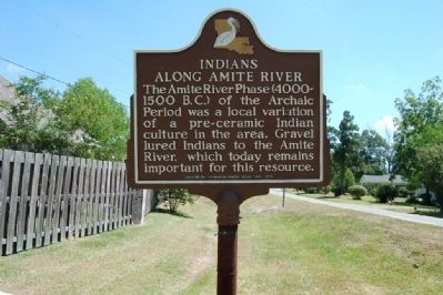 The Amite River Phase (4000-1500 B.C.) of the Archaic Period was a local variation of a pre-ceramic Indian culture in the area. Gravel lured Indians to the Amite River, which today remains important for this resource.
 A grave like any hole dug into the earth interrupts the natural layering of soil. For that reason, it can be distinguished as an anomaly—irregular in texture and color in comparison to undisturbed soil at that level.
 In 1951, when Irvin G. Bieser, Sr. was president of the hospital Board of Trustees, this
cornerstone was placed during construction of the Main Building. A construction addition
in the 1970’s relocated the entry way and the cornerstone became tucked away behind a plastered wall. It was uncovered during renovation in 2008.
In 1951, when Irvin G. Bieser, Sr. was president of the hospital Board of Trustees, this
cornerstone was placed during construction of the Main Building. A construction addition
in the 1970’s relocated the entry way and the cornerstone became tucked away behind a plastered wall. It was uncovered during renovation in 2008. Salem Willows is named for the European white willow trees planted here in 1801 to form a shaded walk for patients convalescing at the old smallpox hospital. Later the area became a park. During the first half of the 20th century Restaurant Row on the park’s north shore served fresh seafood favored by locals and visitors alike. The last of these once popular restaurants closed in the late 1960s. A carousel with carved flying horses was another special attraction at Salem Willows which, as now, operated an, amusement center. Although the restaurants and flying horses are gone, visitors still flock here during the summer to enjoy the seashore, the arcade, and the park’s ample picnic grounds and recreational facilities.
 For decades, the main attraction on the line was the Willows Pavilion. This unusual looking structure boasted a roller skating rink and a 300-seat, second-floor restaurant. In the rear tower, a camera obscura projected scenes from the surrounding area onto a table in a darkened room. Nearby was a theater, built largely of recycled materials from the Siege of Paris pavilion from a Boston exposition.
 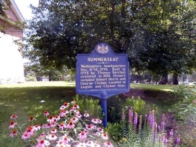 Washington's headquarters Dec. 8-14, 1776. Built in 1773 by Thomas Barkley; restored in 1931. Owners included Robert Morris and George Clymer. Located at Legion and Clymer Aves.
 Headquarters of General Washington December 8-14 1776, owned by Robert Morris 1791-1798, owned by George Clymer 1798-1805, he died in residence 1813. Both Robert Morris and George Clymer signed the Declaration of Independence and the Constitution of the United States
 The large flat bottom boats housed in this barn are reproductions of a mid-18th century vessel known as the Durham boat. Robert Durham, an engineer at the Durham Iron Works in nearby Reiglesville, Pennsylvania, reputedly designed a prototype for these large cargo boats as early as 1757. Durham boats hauled cargo along the entire length of the Delaware River. These long-run vessels transported ore, fir, timber, and produce down the Delaware River to Philadelphia’s thriving markets. The largest vessels (up to 65 feet long and 8 feet in the beam) could transport 20 tons of iron or 150 barrels of flour downstream.
Durham boats played an important role in Washington’s crossing of the Delaware River on December 25, 1776. General Washington wrote to Governor Livingston of New Jersey directing him to secure “Boats and Craft,…should be secured…particularly the Durham Boats…” for his anticipated crossing and planned attack on Trenton. Although designed to haul cargo, the Durham boats successfully carried Washington’s troops across the icy Delaware in the early morning hours prior to the attack.
The large flat bottom boats housed in this barn are reproductions of a mid-18th century vessel known as the Durham boat. Robert Durham, an engineer at the Durham Iron Works in nearby Reiglesville, Pennsylvania, reputedly designed a prototype for these large cargo boats as early as 1757. Durham boats hauled cargo along the entire length of the Delaware River. These long-run vessels transported ore, fir, timber, and produce down the Delaware River to Philadelphia’s thriving markets. The largest vessels (up to 65 feet long and 8 feet in the beam) could transport 20 tons of iron or 150 barrels of flour downstream.
Durham boats played an important role in Washington’s crossing of the Delaware River on December 25, 1776. General Washington wrote to Governor Livingston of New Jersey directing him to secure “Boats and Craft,…should be secured…particularly the Durham Boats…” for his anticipated crossing and planned attack on Trenton. Although designed to haul cargo, the Durham boats successfully carried Washington’s troops across the icy Delaware in the early morning hours prior to the attack. The O&W Railroad
 Ancienne résidence archiépiscopale, le Palais du Tau doit son nom à son plan en T. Peu avant 1500, Guillaume Briçonnet le dota d'une grande et lumineuse salle d'honneur au décor flamboyant où se tenaient, entre autres, les festins des sacres. Deux siècle plus tard, Charles-Maurice Le Tellier le transforma en palais classique qui abrite depuis 1972 un muse consacré à la statuaire originale, aux tapisseries et au trésor de la cathédrale. On y voit en particulier le reliquaire de la sainte Ampoule destinée aux onctions royales. Cette huile miraculeuse associée au baptême de Clovis était jadis conserve dans la Basilique Saint-Remi, haut lieu de la mémoire des sacres.
 La pâté de maisons compris entre la cathédral, les rues du Cloître, du Trésor et Carnot étaient réservées aux chanoines. Cet enclose comprenait le cloître, les bâtiments nécessaires a la vie committee, les écoles et toutes les dépendances utiles à l'administration de leurs domains et à l'exercice de leur jurisdiction seigneuriale sur une partie de la ville (granges, celliers, tribunal et prison). Il y avait également des boutiques, en particulier des merciers et des libraires imprimeurs. Ouvert aux passants dans la journée, le quartier était clos le soir comme en témoigne cette porte édifiée en 1531. Ses vantaux de bois sculpté sont désormais dans les reserves du Musée des Beaux-Arts.
 One of thirteen installations in the Philadelphia area that provided protection from Soviet aerial attack during the 1954–1970 period of the Cold War. The Nike system here used radar to guide Ajax anti-aircraft missiles. From the mid-1960s through the early 1970s, this missile system was replaced as technology and terms of arms control treaties evolved. The missile launch area and magazine are located near here.