Texas, Gregg County, Longview
![]() The original site of Longview lay on the western outskirts of Earpville, a pioneer Upshur County community along the old Marshall-Tyle Road (today known as U.S. Highway 80). Founded around 1850 by James Earp, (pronounced "Arpville") consisted of several farmhouses, a post office, blacksmith shop, a church, one or two stores, stagecoach stop and campground.
The original site of Longview lay on the western outskirts of Earpville, a pioneer Upshur County community along the old Marshall-Tyle Road (today known as U.S. Highway 80). Founded around 1850 by James Earp, (pronounced "Arpville") consisted of several farmhouses, a post office, blacksmith shop, a church, one or two stores, stagecoach stop and campground.
After the War between the States, Northern capital allowed the Southern Pacific Railroad to expand toward California from the pre-war terminus at Marshall. The Southern Pacific purchased a 100-acre tract in April 1870 from farmer O.H. Methvin, laying out a town site in advance of track construction. The name "Longview," was selected for the new town and was inspired by the scenic view from atop Rock Hill, where Methvin's home was located.
(Railroads & Streetcars • Roads & Vehicles • Settlements & Settlers) Includes location, directions, 6 photos, GPS coordinates, map.
 The original site of Longview lay on the western outskirts of Earpville, a pioneer Upshur County community along the old Marshall-Tyle Road (today known as U.S. Highway 80). Founded around 1850 by James Earp, (pronounced "Arpville") consisted of several farmhouses, a post office, blacksmith shop, a church, one or two stores, stagecoach stop and campground.
After the War between the States, Northern capital allowed the Southern Pacific Railroad to expand toward California from the pre-war terminus at Marshall. The Southern Pacific purchased a 100-acre tract in April 1870 from farmer O.H. Methvin, laying out a town site in advance of track construction. The name "Longview," was selected for the new town and was inspired by the scenic view from atop Rock Hill, where Methvin's home was located.
(Railroads & Streetcars • Roads & Vehicles • Settlements & Settlers) Includes location, directions, 6 photos, GPS coordinates, map.
 Sale of lots began in September 1870, with the Southern Pacific buying another 50 acres from O.H. Methvin to extend its town site further west. To attract investors and to speed development, streets were given a metropolitan width of 100 feet. The Longview Post Office was established Jan. 27, 1871, with O.H. Pegues, Jr. appointed first postmaster.
 By 1872, Longview received nationwide attention by serving as temporary head of the nation's Southern rail line. Business, population and construction were stimulated by wagon traffic from a large area since Longview provided the closest rail access.
 In January 1873, Upshur County Representative B.W. Brown (a Methodist lay preacher) introduced a bill in the Texas Legislature to make Longview the seat of a new county to be composed of portions of existing Upshur, Rusk and Harrison counties. The county of Gregg (named for slain Confederate General John Gregg) was created, although initially composed of only 143 square miles taken from Upshur County.
 Around here someplace was almost Yolo County's first courthouse, It was here twice -- from 1851 to 1857 and from 1861 to 1863 -- when it was stolen permanently by The "Highbinders" in Woodland.


 Instituted May, 1881
 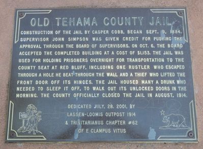 Construction of the jail by Casper Cobb, began Sept. 9, 1884. Supervisor John Simpson was given credit for pushing the approval through the Board of Supervisors. On Oct. 6, the board accepted the completed building at a cost of $1,153. The jail was used for holding prisoners overnight for transportation to the county seat at Red Bluff, including one rustler who escaped through a hole he beat through the wall and a thief who lifted the front door off its hinges. The jail housed many a drunk who needed to sleep it off, to walk out its unlocked doors in the morning. The county officially closed the jail in August, 1914.
 Founded December 10, 1979
  Built in 1891, DeWitt School typifies the one-room schools of the turn of the century. It stands on an acre of land that was donated by the DeWitt and Bosch families. Classes for grades one through eight were held in it until 1957. At one time, a single teacher taught from twenty-five to forty students by holding one ten-minute session per subject for each of the eight grades. The original school district covered approximately four square miles, and many children walked more than two miles to and from school daily. Nearly two decades after the school closed, planning began for restoring it as a living museum for area school children. By 1979 the classroom resembled its 1891 appearance, featuring gas lights, a wood stove, an octagonal clock, a hanging globe, lunch pails and desk.
 This Queen Anne style structure was built in 1890 as the Van Alten family residence. In the 1900's Nick Wilson converted the home into The Commercial House Saloon and Hotel. Over the Years it remained a tavern and restaurant. In 2014, Barkha and Jesse Daily renovated the building and is now home to their restaurant, "The Cheel" at The Commercial House.
 The building was constructed by Ernst Van Alten as a hotel, tavern, and restaurant. Many of its patrons were customers of the Thiensville Mill. It was later purchased by Louis Kieker Sr. and known as the Kieker Tavern in the 1890s.
 This turnstyle bridge served the California & Oregon Railroad Co. It was surveyed in September 1870 and was completed in August 1871. The bridge was first crossed by the steam locomotive "Falcon" and by the "Clipper" the following day with one passenger and a baggage car.
  The first Central School was built 1871. The Grand Haven Tribune hailed the belfry-topped school as the "finest in the state" and "the pride of every citizen of Grand Haven." The newspaper blamed arsonists for burning the school on May 5, 1901, and stated that more than one man would "contribute his services to a lynching bee, if the firebug could be detected." A second school, built on this site in 1902, housed over 600 students in grades kindergarten through twelve. That school burned in 1963. The bell from the school was salvaged, but not usable. The following year the present elementary school opened. In 1965 the local Methodist church donated a bell from its old church so that the school could continue its tradition of ringing a school bell to call students to class.
 En française:


