Fort Oglethorpe, Georgia.
![]() Illinois 21st Infantry, Carlin's Brigade. 11 A.M. September 20, 1863
Illinois 21st Infantry, Carlin's Brigade. 11 A.M. September 20, 1863
(Parks & Recreational Areas • War, US Civil) Includes location, directions, 3 photos, GPS coordinates, map.
 Illinois 21st Infantry, Carlin's Brigade. 11 A.M. September 20, 1863
(Parks & Recreational Areas • War, US Civil) Includes location, directions, 3 photos, GPS coordinates, map.
 Text on the front of the monument The Commonwealth of Pennsylvania. to her 78th Infantry Regiment Lieut. Col. Archibald Kelly, Commanding. Chickamauga -- Chattanooga Sept. 18th 19th and 20th, 1863 – Nov. 23rd 24th and . . .
  65th Regiment Ohio Infantry, Harker’s Brigade. 5:00 P.M. September 19, 1863.
 William Bartram Naturalist Visited this area of the Cherokee Nation in May, 1775 while on his mission to record the natural and cultural resources along the trading route between the Low Country to the east and the Overhill . . .
  The North Carolina Bartram Trail is a hiking trail to commemorate the 1775 visit of Philadelphia naturalist William Bartram to Western North Carolina. Begun in the 1970s, the trail parallels Bartram's actual route into . . .
  Long before the first settlers arrived here in 1818, this area teased explorers with hints of mineral wealth — especially gold, silver and copper. Not much interest was taken in Macon County's gemstones until a farmer turned . . .
  Time on Target After World War II, the Army learned that an artillery barrage produces the most casualties in the first few seconds before the enemy could seek cover. In response, the Army learned to time fire from multiple . . .
  The Hyde Hall Covered Bridge was built in 1825 as part of the 1817-1835 construction of George Clark's country estate, Hyde Hall. Built by Cyrenus Clark, Andrew Alden, and Lorenzo Bates, this 53-foot-long, single span . . .
  . . .
. . .  The United States Forest Service's first fire lookouts system was a crude setup of tents and crow's nest lookouts. Watching for wild fires in unpopulated areas was a relatively new idea and was regarded with little . . .
  Jenny Leigh, a Shoshone Indian, assisted the 1872 Hayden Survey. The expedition named this lake in her honor. Jenny and her husband Richard were expert guides who knew Jackson Hole well from summers spent hunting, trapping, . . .
  Front Settled ca. 1800 by Rev. War veterans Thos. Carson, John Helm, & Matthew Kuykendall who received land grants for their service. These founders of Butler County served as first county surveyor, presiding justice of . . .
  CSA Gen. Nathan Bedford Forrest and cavalry came here 3 times on reconnaissance missions from Hopkinsville. Captured USA arms and equipment here, Nov. 24, 1861. Moved through here Dec. 28 on way to victory over larger USA . . .
  Every inhabitant of this pro-southern town was taken prisoner by the crew of a Union gunboat, July 26. 1862. All were released except 19 men who were taken to Evansville. Ind., as hostages to guarantee payment of $35,000 . . .
  Catherine de Longpré nait à Saint-Sauveur-le-Vicomte en Normandie, à douze ans et demi, elle entre au monastère des Augustines à Bayeux. À quatorze ans, elle s'offre pour aller évangelisér en Nouvelle-France. Le 31 mai 1648, . . .
  Side 1 In the early nineteenth century Methodists began holding camp meetings, an outgrowth of their early revivals. Revival services were held during the winter months, and late summer was generally reserved for the . . .
  Founded in 1908 by James A. Peoples and Everett B. Tucker, this school operated from this site until 1925. Its founders, graduates of William R. Webb's famous school at Culleoka, later at Bell Buckle, followed largely the . . .
  ? Tennessee ? Robertson County Established 1796: named in honor of James Robertson Leader in establishment of the Watauga Settlement in East Tennessee. In 1778, explored the Cumberland country; in 1779 led an expedition . . .
  Returning from the Kentucky Campaign of September-October, 1862, his command now consisting of the 2nd, 7th and 9th Kentucky Calvary, Colonel John Hunt Morgan stopped briefly in this region, while a detachment under Lt. . . .
 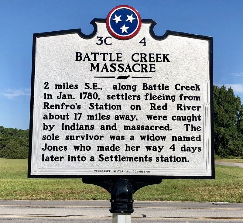 2 miles S.E., along Battle Creek in Jan. 1780, settlers fleeing from Renfro's Station on Red River about 17 miles away, were caught by Indians and massacred. The sole survivor was a widow named Jones who made her way 4 days . . .