February 12, 2019, 9:12 pm
Sodus Point, New York.![]()
On the brow of this hill took place the battle of Sodus Point between the British and American forces June 19, 1813. The following day the village of Sodus Point was sacked and burned by the British.
(War of 1812) Includes location, directions, 3 photos, GPS coordinates, map.
↧
February 12, 2019, 9:17 pm
Hampton, Virginia.![]()
John Thorowgood Jr., Revolutionary-Era leader, lived on an 840-acre plantation near here, on Little Creek. He was elected to the Convention of 1776, which adopted Virginia’s resolutions for independence, the Virginia . . .
(Colonial Era • Forts, Castles • War of 1812) Includes complete text, location, directions, 2 photos, GPS coordinates, map.
↧
↧
February 12, 2019, 9:25 pm
Palisades, District of Columbia.![]()
Baking bread, frying cornbead and eating "stick to your ribs" oatmeal, all have one thing in common; their ingredients started out at a grist mill. Decades before the sounds of lockhorns and mule hooves clopping by, mills . . .
(Industry & Commerce • Waterways & Vessels • Women) Includes complete text, location, directions, 3 photos, GPS coordinates, map.
↧
February 12, 2019, 9:32 pm
Palisades, District of Columbia.![]()
Here, in 1876, an engineering marvel was built. The largest incline plane in the world and the first built in the United States, carried canal boats to and from the Potomac River. The incline plane was used to help clear . . .
(Industry & Commerce • Science & Medicine • Waterways & Vessels) Includes complete text, location, directions, 3 photos, GPS coordinates, map.
↧
February 12, 2019, 9:38 pm
Hampton, Virginia.![]()
A group of prominent local African Americans formed the Bay Shore Hotel Company, purchased land here, and in 1898 opened a resort for black travelers. Ravaged by an Aug. 1933 hurricane, the resort was rebuilt and operated . . .
(African Americans • Entertainment • Industry & Commerce) Includes complete text, location, directions, 5 photos, GPS coordinates, map.
↧
↧
February 12, 2019, 9:44 pm
Virginia Beach, Virginia.![]()
John Thorowgood Jr., Revolutionary-Era leader, lived on an 840-acre plantation near here, on Little Creek. He was elected to the Convention of 1776, which adopted Virginia’s resolutions for independence, the Virginia . . .
(Patriots & Patriotism • Politics • War, US Revolutionary) Includes complete text, location, directions, 3 photos, GPS coordinates, map.
↧
February 13, 2019, 7:45 am
Hampton, Virginia.![]()
This house was the last headquarters of the Virginia State Federation of Colored Women’s Clubs, organized In 1907 by educator and social reformer Janie Porter Barrett and other women who attended the annual Hampton Negro . . .
(African Americans • Charity & Public Work • Women) Includes complete text, location, directions, 3 photos, GPS coordinates, map.
↧
February 13, 2019, 7:49 am
Concord, New Hampshire.![]()
Placed in Memory of Those Men and Women, Living or Dead, Who, Since These United States, Were Settled, Have Fought to Preserve Our Great Heritage of Freedom. By the Grateful Citizens of East Concord. 1961
(Patriots & Patriotism) Includes location, directions, 2 photos, GPS coordinates, map.
↧
February 13, 2019, 7:57 am
Fultonville, New York.![]()
By the Numbers 5,900 Square Miles Six thriving Counties More Than 500,000 Residents Homeland of the Iroquois For centuries, the ancestral homeland of the Native American Iroquois included the Mohawk Valley region. French, . . .
(Native Americans • Settlements & Settlers) Includes complete text, location, directions, 2 photos, GPS coordinates, map.
↧
↧
February 13, 2019, 8:01 am
Concord, New Hampshire.![]()
Erected By The Eastman Association In Memory of Captain Ebenezer Eastman First Settler of Concord 1727 1924
(Colonial Era • Settlements & Settlers) Includes location, directions, 4 photos, GPS coordinates, map.
↧
February 13, 2019, 8:06 am
Fultonville, New York.![]()
The Burning of the Valleys Aimed at disrupting supply lines and devastating the crops that fed troops during the Revolutionary War, the Burning of the Valleys was a ruthless campaign waged against civilians and led by the . . .
(War, US Revolutionary) Includes complete text, location, directions, 1 photo, GPS coordinates, map.
↧
February 13, 2019, 8:10 am
Waldorf, Maryland.![]()
This Stadium is Dedicated in Memory of John Thomas Parran, Jr. 1926—2006 Athlete, Legislator, Statesman, Mentor, and Friend Citizen of Charles County and Southern Maryalnd Pitcher for the Indian Head Indians Charles—St. . . .
(Parks & Recreational Areas • Politics • Sports) Includes complete text, location, directions, 6 photos, GPS coordinates, map.
↧
February 13, 2019, 8:19 am
New York, New York.![]()
The African Burial Ground was active until 1794. Within an area of not quite six acres, perhaps as many as 20,000 people were interred, mostly free or enslaved Africans. During the 18th century, one in ten residents of New . . .
(African Americans • Cemeteries & Burial Sites • Colonial Era) Includes complete text, location, directions, 6 photos, GPS coordinates, map.
↧
↧
February 13, 2019, 8:28 am
Fultonville, New York.![]()
Locks Open the Way The Erie Canal originally scaled some 700 feet in elevation changes along its route from Rome, New York to Buffalo. This was accomplished by building a series of 83 locks to accomodate changes in water . . .
(Waterways & Vessels) Includes complete text, location, directions, 1 photo, GPS coordinates, map.
↧
February 13, 2019, 8:32 am
Fultonville, New York.![]()
Feeding an Army A plentiful source of wheat and dairy, the Mohawk and Schoharie Valleys have long been vital farmlands. They were the targets for the British during the revolutionary War because they were important sources . . .
(Agriculture • War, US Revolutionary) Includes complete text, location, directions, 1 photo, GPS coordinates, map.
↧
February 13, 2019, 9:47 am
Hampton, Virginia.![]()
In 1906, the Virginia General Assembly authorized the Virginia School for Colored Deaf and Blind Children. Founded by deaf humanitarian William C. Ritter and Hampton Delegate Harry R. Houston, the school opened on 8 Sept. . . .
(African Americans • Agriculture • Education) Includes complete text, location, directions, 3 photos, GPS coordinates, map.
↧
February 13, 2019, 9:55 am
Ybor City, Florida.![]()
On September 22, 1912 Anthony P.(Tony) Pizzo was born in the family home on this block, neighboring the family livery stable, and eventually produce store, dating from the 1870's. Tony's love of his community and his . . .
(Notable Persons) Includes complete text, location, directions, 1 photo, GPS coordinates, map.
↧
↧
February 13, 2019, 10:02 am
Ybor City, Florida.![]()
The first citizen of Ybor City was Gavino Gutierrez, Spanish civil engineer. Gutierrez investigated the area in 1884 as a site for a guava processing plant. The guava plant was never erected, but on the strength of Gutierrez . . .
(Notable Persons) Includes complete text, location, directions, 1 photo, GPS coordinates, map.
↧
February 13, 2019, 10:40 am
Truckee, California.![]()
The pioneer began their trek across the continent with expectations of a new life. In sparsely populated California they could have land with fertile soil and a pleasant climate. They heard about the wonders of California . . .
(Disasters • Settlements & Settlers) Includes complete text, location, directions, 2 photos, GPS coordinates, map.
↧
February 13, 2019, 10:50 am
near Truckee, California.![]()
The Donner family and their hired teamsters left Springfield, Illinois in April, 1846. At Independence, Missouri, their wagons joined hundreds of others traveling west on the Oregon-California Trail. The New Captain Takes a . . .
(Disasters • Settlements & Settlers) Includes complete text, location, directions, 2 photos, GPS coordinates, map.
↧
 On the brow of this hill took place the battle of Sodus Point between the British and American forces June 19, 1813. The following day the village of Sodus Point was sacked and burned by the British.
 John Thorowgood Jr., Revolutionary-Era leader, lived on an 840-acre plantation near here, on Little Creek. He was elected to the Convention of 1776, which adopted Virginia’s resolutions for independence, the Virginia . . .
  Baking bread, frying cornbead and eating "stick to your ribs" oatmeal, all have one thing in common; their ingredients started out at a grist mill. Decades before the sounds of lockhorns and mule hooves clopping by, mills . . .
  Here, in 1876, an engineering marvel was built. The largest incline plane in the world and the first built in the United States, carried canal boats to and from the Potomac River. The incline plane was used to help clear . . .
  A group of prominent local African Americans formed the Bay Shore Hotel Company, purchased land here, and in 1898 opened a resort for black travelers. Ravaged by an Aug. 1933 hurricane, the resort was rebuilt and operated . . .
  John Thorowgood Jr., Revolutionary-Era leader, lived on an 840-acre plantation near here, on Little Creek. He was elected to the Convention of 1776, which adopted Virginia’s resolutions for independence, the Virginia . . .
  This house was the last headquarters of the Virginia State Federation of Colored Women’s Clubs, organized In 1907 by educator and social reformer Janie Porter Barrett and other women who attended the annual Hampton Negro . . .
  Placed in Memory of Those Men and Women, Living or Dead, Who, Since These United States, Were Settled, Have Fought to Preserve Our Great Heritage of Freedom. By the Grateful Citizens of East Concord. 1961
 By the Numbers 5,900 Square Miles Six thriving Counties More Than 500,000 Residents Homeland of the Iroquois For centuries, the ancestral homeland of the Native American Iroquois included the Mohawk Valley region. French, . . .
  Erected By The Eastman Association In Memory of Captain Ebenezer Eastman First Settler of Concord 1727 1924
 The Burning of the Valleys Aimed at disrupting supply lines and devastating the crops that fed troops during the Revolutionary War, the Burning of the Valleys was a ruthless campaign waged against civilians and led by the . . .
  This Stadium is Dedicated in Memory of John Thomas Parran, Jr. 1926—2006 Athlete, Legislator, Statesman, Mentor, and Friend Citizen of Charles County and Southern Maryalnd Pitcher for the Indian Head Indians Charles—St. . . .
  The African Burial Ground was active until 1794. Within an area of not quite six acres, perhaps as many as 20,000 people were interred, mostly free or enslaved Africans. During the 18th century, one in ten residents of New . . .
  Locks Open the Way The Erie Canal originally scaled some 700 feet in elevation changes along its route from Rome, New York to Buffalo. This was accomplished by building a series of 83 locks to accomodate changes in water . . .
 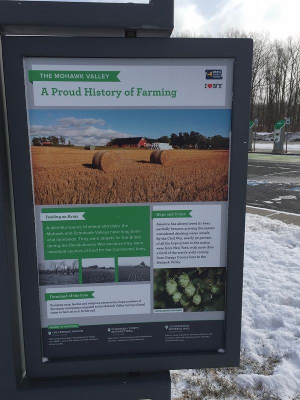 Feeding an Army A plentiful source of wheat and dairy, the Mohawk and Schoharie Valleys have long been vital farmlands. They were the targets for the British during the revolutionary War because they were important sources . . .
  In 1906, the Virginia General Assembly authorized the Virginia School for Colored Deaf and Blind Children. Founded by deaf humanitarian William C. Ritter and Hampton Delegate Harry R. Houston, the school opened on 8 Sept. . . .
  On September 22, 1912 Anthony P.(Tony) Pizzo was born in the family home on this block, neighboring the family livery stable, and eventually produce store, dating from the 1870's. Tony's love of his community and his . . .
  The first citizen of Ybor City was Gavino Gutierrez, Spanish civil engineer. Gutierrez investigated the area in 1884 as a site for a guava processing plant. The guava plant was never erected, but on the strength of Gutierrez . . .
  The pioneer began their trek across the continent with expectations of a new life. In sparsely populated California they could have land with fertile soil and a pleasant climate. They heard about the wonders of California . . .
  The Donner family and their hired teamsters left Springfield, Illinois in April, 1846. At Independence, Missouri, their wagons joined hundreds of others traveling west on the Oregon-California Trail. The New Captain Takes a . . .