November 2, 2018, 7:49 pm
Naples, New York.![]()
Harnessing the Power Water gushing out of Grimes Glen was dammed at the mouth of the glen and directed into a wooden raceway that carried it to mills throughout the village. The raceway fed Naples Mill, along the route that . . .
(Industry & Commerce) Includes complete text, location, directions, 3 photos, GPS coordinates, map.
↧
↧
November 3, 2018, 6:51 am
Breaux Bridge, Louisiana.![]()
English Side Founded 1859. Long recognized for its culinary artistry in the preparation of crawfish. The 1958 Louisiana Legislature officially designated Breaux Bridge "La Capitale Mondiale De L'Ecrevisse" in honor of its . . .
(Settlements & Settlers) Includes complete text, location, directions, 3 photos, GPS coordinates, map.
↧
November 3, 2018, 7:11 am
St. Martinville, Louisiana.![]()
This parish was one of the sites proposed by Bishop Jules B. Jeanmard, Bishop of the Diocese of Lafayette, to afford a place of work for African-American priests ordained in the United States in 1934. Rev. Maurice Rousseve, . . .
(African Americans • Churches & Religion) Includes complete text, location, directions, 2 photos, GPS coordinates, map.
↧
November 3, 2018, 10:55 am
, Mexico.![]()
Atrio de los olivos La fisonomía del atrio ha variado a través de los siglos, la parroquia de San Pedro fue remozada por los jesuitas en 1618 y muy probablemente también el atrio. Su traza actual de estilo barroco, se . . .
(Churches & Religion • Colonial Era • Man-Made Features • Parks & Recreational Areas) Includes complete text, location, directions, 2 photos, GPS coordinates, map.
↧
November 3, 2018, 11:23 am
Crowley, Louisiana.![]()
Built in 1948 Miller Stadium served as the home of the Crowley Millers who played in South Louisiana's semi-pro Teche League and the professional Gulf coast and Evangeline Leagues from 1948 to 1957. Popular with baseball . . .
(Sports) Includes complete text, location, directions, 3 photos, GPS coordinates, map.
↧
↧
November 3, 2018, 5:31 pm
Boise, Idaho.![]()
Julia Davis Park was donated to the City of Bosie by the area's first homesteader, Thomas Jefferson Davis. He arrived in Boise in the spring of 1863, and his claim was the first to be filed in Idaho Territory. The claim was . . .
(Architecture • Parks & Recreational Areas) Includes complete text, location, directions, 2 photos, GPS coordinates, map.
↧
November 3, 2018, 5:46 pm
Boise, Idaho.![]()
Few things in Boise compare with the quiet charm of Julia Davis Park. Edging the north bank of the Boise River downstream from Broadway Ave. to just beyond Capitol Blvd., this emerald jewel is the setting for the city's . . .
(Notable Persons • Settlements & Settlers) Includes complete text, location, directions, 2 photos, GPS coordinates, map.
↧
November 3, 2018, 5:58 pm
Boise, Idaho.![]()
Soon after the discovery of Gold in Northern Idaho (1862) the City of Boise was founded (1863). Its first people were the U.S. Cavalry, Merchants, Mining and Stockmen. Although a few Mormons from Utah had previously lived in . . .
(Churches & Religion) Includes complete text, location, directions, 2 photos, GPS coordinates, map.
↧
November 3, 2018, 7:57 pm
Rivière-du-Loup, Quebec.![]()
Un premier hôtel de ville à Fraserville Le chantier pour la construction de l'hôtel de ville débute au printemps 1902 et l'ouverture officielle a lieu un an plus tard, à Pâques, le dimanche 12 avril 1903. La première séance . . .
(Notable Buildings) Includes complete text, location, directions, 3 photos, GPS coordinates, map.
↧
↧
November 3, 2018, 9:00 pm
, United Kingdom.![]()
At 7pm on 14th December 1914 Winston Churchill, First Lord of the Admiralty, was told that "a battle cruiser attack on the East Coast was probably imminent", although what the precise objectives were it was impossible to . . .
(War, World I) Includes complete text, location, directions, 3 photos, GPS coordinates, map.
↧
November 3, 2018, 9:00 pm
, United Kingdom.![]()
It was thought that a buoy which the German fleet used as a guide had been moved further inland and the nearness of the German ships to the coast was the salvation of the batteries. A longer range would have given a . . .
(War, World I) Includes complete text, location, directions, 3 photos, GPS coordinates, map.
↧
November 3, 2018, 9:00 pm
, United Kingdom.![]()
A Trophy From Sebastopol This Cannon Was Captured From the Russian Army At the Battle of Sebastopol During the Crimean War (1854-56). In October, 1857 The then Secretary of State, Lord Panmure, Offered the Cannon to . . .
(Military) Includes complete text, location, directions, 4 photos, GPS coordinates, map.
↧
November 3, 2018, 9:00 pm
, United Kingdom.![]()
The Bombardment of the Hartlepools This memorial commemorates all those across the Hartlepools who were killed or wounded due to the naval bombardment of the 16th December 1914. At least 114 civilians, 9 soldiers and 7 . . .
(War, World I) Includes complete text, location, directions, 3 photos, GPS coordinates, map.
↧
↧
November 3, 2018, 9:01 pm
, United Kingdom.![]()
Welcome to the Headland Ancient Borough of Hartlepool This Gateway Marker was erected 2001 AD to celebrate the 800th Anniversary of the grant of a Charter by King John to the citizens of Herterpool, The historic Borough of . . .
(Settlements & Settlers) Includes complete text, location, directions, 4 photos, GPS coordinates, map.
↧
November 4, 2018, 4:51 am
Lafayette, Louisiana.![]()
These centurion live oak trees shaded Ile Copal, the plantation home of Alexandre Mouton. Mouton was governor of Louisiana from 1843-46 and son of the founder of Vermilionville. Here marks the beginning of a shady lane of . . .
(Antebellum South, US • Education • Horticulture & Forestry • Settlements & Settlers) Includes complete text, location, directions, 2 photos, GPS coordinates, map.
↧
November 4, 2018, 8:03 am
, Mexico.![]()
Portada del Siglo XVII Esta sencilla portada lateral, corresponde a la primera etapa constructiva del templo de San Francisco Javier (1670-1682). Sobre el entablamento, se destaca un nicho que alberga la imagen de San . . .
(Architecture • Churches & Religion • Colonial Era • Man-Made Features) Includes complete text, location, directions, 3 photos, GPS coordinates, map.
↧
November 4, 2018, 9:33 am
Boise, Idaho.![]()
"... we found a gap in the bluffs of Boise valley, where we turned down and succeeded in reaching the valley in safety, although our road was very steep and stony, and long..." -- P.V. Crawford, 1851 P.V. Crawford may have . . .
(Roads & Vehicles • Settlements & Settlers) Includes complete text, location, directions, 3 photos, GPS coordinates, map.
↧
↧
November 4, 2018, 9:46 am
Boise, Idaho.![]()
Along this historic trail, from 1841 to 1861, traveled the greatest land migration in history. Nearly half a million pioneers came to settle America's Northwest. One out of every eight would perish along the way.
(Roads & Vehicles • Settlements & Settlers) Includes location, directions, 4 photos, GPS coordinates, map.
↧
November 4, 2018, 10:08 am
Boise, Idaho.![]()
"When we first came in sight of Boise City and valley we were upon a hill seven miles distant." -- Julius Caesar Merrill, 1864 Creaking, groaning wheels, the dust so thick that the hunch-back oxen ahead looked more like . . .
(Roads & Vehicles • Settlements & Settlers) Includes complete text, location, directions, 3 photos, GPS coordinates, map.
↧
November 4, 2018, 10:52 am
, Mexico.![]()
Fachada Principal de la Iglesia de San Francisco Javier La fachada y la torre, ejemplos sobresalientes del barroco estípite del siglo XVIII (churrigueresco mexicano), fueron construidas de 1760 a 1762. La actual fachada se . . .
(Architecture • Churches & Religion • Colonial Era • Man-Made Features) Includes complete text, location, directions, 2 photos, GPS coordinates, map.
↧
 Harnessing the Power Water gushing out of Grimes Glen was dammed at the mouth of the glen and directed into a wooden raceway that carried it to mills throughout the village. The raceway fed Naples Mill, along the route that . . .
  English Side Founded 1859. Long recognized for its culinary artistry in the preparation of crawfish. The 1958 Louisiana Legislature officially designated Breaux Bridge "La Capitale Mondiale De L'Ecrevisse" in honor of its . . .
 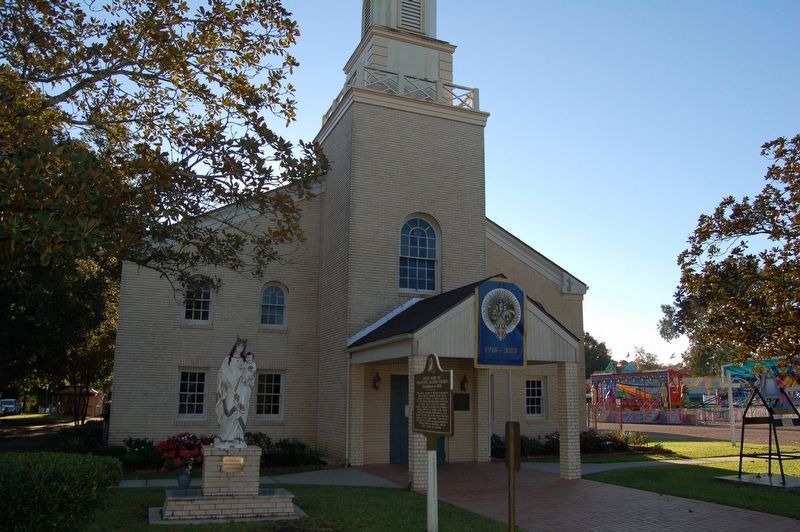 This parish was one of the sites proposed by Bishop Jules B. Jeanmard, Bishop of the Diocese of Lafayette, to afford a place of work for African-American priests ordained in the United States in 1934. Rev. Maurice Rousseve, . . .
  Atrio de los olivos La fisonomía del atrio ha variado a través de los siglos, la parroquia de San Pedro fue remozada por los jesuitas en 1618 y muy probablemente también el atrio. Su traza actual de estilo barroco, se . . .
  Built in 1948 Miller Stadium served as the home of the Crowley Millers who played in South Louisiana's semi-pro Teche League and the professional Gulf coast and Evangeline Leagues from 1948 to 1957. Popular with baseball . . .
  Julia Davis Park was donated to the City of Bosie by the area's first homesteader, Thomas Jefferson Davis. He arrived in Boise in the spring of 1863, and his claim was the first to be filed in Idaho Territory. The claim was . . .
  Few things in Boise compare with the quiet charm of Julia Davis Park. Edging the north bank of the Boise River downstream from Broadway Ave. to just beyond Capitol Blvd., this emerald jewel is the setting for the city's . . .
  Soon after the discovery of Gold in Northern Idaho (1862) the City of Boise was founded (1863). Its first people were the U.S. Cavalry, Merchants, Mining and Stockmen. Although a few Mormons from Utah had previously lived in . . .
  Un premier hôtel de ville à Fraserville Le chantier pour la construction de l'hôtel de ville débute au printemps 1902 et l'ouverture officielle a lieu un an plus tard, à Pâques, le dimanche 12 avril 1903. La première séance . . .
  At 7pm on 14th December 1914 Winston Churchill, First Lord of the Admiralty, was told that "a battle cruiser attack on the East Coast was probably imminent", although what the precise objectives were it was impossible to . . .
  It was thought that a buoy which the German fleet used as a guide had been moved further inland and the nearness of the German ships to the coast was the salvation of the batteries. A longer range would have given a . . .
  A Trophy From Sebastopol This Cannon Was Captured From the Russian Army At the Battle of Sebastopol During the Crimean War (1854-56). In October, 1857 The then Secretary of State, Lord Panmure, Offered the Cannon to . . .
  The Bombardment of the Hartlepools This memorial commemorates all those across the Hartlepools who were killed or wounded due to the naval bombardment of the 16th December 1914. At least 114 civilians, 9 soldiers and 7 . . .
  Welcome to the Headland Ancient Borough of Hartlepool This Gateway Marker was erected 2001 AD to celebrate the 800th Anniversary of the grant of a Charter by King John to the citizens of Herterpool, The historic Borough of . . .
  These centurion live oak trees shaded Ile Copal, the plantation home of Alexandre Mouton. Mouton was governor of Louisiana from 1843-46 and son of the founder of Vermilionville. Here marks the beginning of a shady lane of . . .
  Portada del Siglo XVII Esta sencilla portada lateral, corresponde a la primera etapa constructiva del templo de San Francisco Javier (1670-1682). Sobre el entablamento, se destaca un nicho que alberga la imagen de San . . .
  "... we found a gap in the bluffs of Boise valley, where we turned down and succeeded in reaching the valley in safety, although our road was very steep and stony, and long..." -- P.V. Crawford, 1851 P.V. Crawford may have . . .
  Along this historic trail, from 1841 to 1861, traveled the greatest land migration in history. Nearly half a million pioneers came to settle America's Northwest. One out of every eight would perish along the way.
 "When we first came in sight of Boise City and valley we were upon a hill seven miles distant." -- Julius Caesar Merrill, 1864 Creaking, groaning wheels, the dust so thick that the hunch-back oxen ahead looked more like . . .
  Fachada Principal de la Iglesia de San Francisco Javier La fachada y la torre, ejemplos sobresalientes del barroco estípite del siglo XVIII (churrigueresco mexicano), fueron construidas de 1760 a 1762. La actual fachada se . . .


