Arkansas, Carroll County, Eureka Springs![]()
"It is sometimes called The Basin Springs, and is invariably the first resort for visitors. If there is any one in the city you desire to find, if no other way, go to the Basin Springs, seat yourself comfortable, and await his coming."
Prof. L.J. Kalklosch, The Healing Fountain, 1881.
[Inset photo captions read]
The earliest visitors to this place in the wilderness that would become Eureka Springs were here in desperate need of better health. Long known as a healing spring by Native Americans, the water was thought to cure all kinds of illness. Health-seekers flocked here in 1879, arriving on foot, horseback and in wagons. These were mostly poor people who had exhausted all other remedies. They lived in covered wagons, tents and rough shacks. Days were spent sociably walking from spring to spring with tin cups and water bottles to drink from each.
————————
By the 1890s Eureka Springs was becoming a fine spa resort. Basin Park had fine hotels on either side. The Southern Hotel on the south and The Perry House on the north. After The Perry House burned it was replaced with the Basin Park Hotel in 1905, the last of the big hotels.
————————
Since the 1880s, one of the landmarks of Spring Street has been the Flatiron Building. This is the fourth one to stand in this spot. Note the fine new brick buildings in this 1890s photograph. The original wooden structures were destroyed in a series of Great Fires.
In The Neighborhood
Rock House Cave: South of the park is a wooden stairway which is actually Rock House Avenue, a city street. Up the stairs, behind the building is Rock House Cave, viewed only from the stairway.
Bluff Shelter: The Bluff Shelter and the outlet for Basin Springs are on the hillside above the park.
The 1905 Basin Park Hotel: The hotel was noted by Ripley's Believe It or Not as a seven story hotel with a ground floor entrance on each level. Several of these entrances can be seen from the gazebo.
Balm of Life Sign: The arch sign is a replica of an early sign placed over the spring near the current site of the Bandshell. It was a gift to Eureka Springs from the local Rotary Club on the 125th anniversary of the city in 2004.
(Environment • Industry & Commerce • Man-Made Features • Science & Medicine) Includes location, directions, 5 photos, GPS coordinates, map.
 Dedicated to all men and women who served in WWII from 1941-1946
 Honoring with Pride Costilla County Veterans


 The main trail of the Chickasaws from their towns in Pontotoc, Miss., here reached the Bayou Gayoso after following roughly the line of Highway 78, Lamar Boulevard, and Marshall Street.
 The Blues Foundation, the world’s premier organization dedicated to honoring, preserving, and promoting the blues, was founded in Memphis in 1980. Mississippi-born performers and business professionals in the Foundation’s Blues Hall of Fame outnumber those from any other state, and Mississippians have also won many annual Blues Music Awards, Keeping the Blues Alive Awards, and international Blues Challenge talent competitions sponsored by the Foundation.
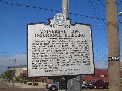 Universal Life Insurance Building
 In 1952, Roberta Church became the first black woman in Memphis to be elected to public office and to the Tennessee Republican State Executive Committee. She served as an official in the administrations of Presidents Eisenhower and Nixon. In 1987, Church was the first woman and the first Black named Senior Citizen of the Year by the Kiwanis Club of Memphis. The daughter of Republican leader Robert R. Church, Jr., and the granddaughter of Robert R. Church, Sr., her death ended three generations of Churches who were economically, politically and socially active in Memphis.

 Life in Aiken
 Dedicated
 Dedicated to
 1918
1918

 In Loving Appreciation
 Toccoa Falls College presents


