December 18, 2017, 6:04 am
St. Augustine, Florida.![]()
Coquina stone was quarried on Anastasia Island for use as a construction material, and after the Castillo was completed the material became widely used for private homes as a superior alternative to wood frame construction. . . .
(Architecture • Colonial Era) Includes complete text, location, directions, 2 photos, GPS coordinates, map.
↧
↧
December 18, 2017, 6:05 am
St. Augustine, Florida.![]()
These two buildings, at 42 and 46 Bridge Street, are among the few Territorial Period buildings left in the city which represent the time period between 1821 and 1845. Antonio Canova purchased the property and built these . . .
(Architecture • Settlements & Settlers) Includes complete text, location, directions, 2 photos, GPS coordinates, map.
↧
December 18, 2017, 6:07 am
St. Augustine, Florida.![]()
Xavier Lopez, descendant from a pioneer Minorcan family, succeeded as a merchant and public servant. He owned the house, passing it to his daughter upon his death. The house is significant as one of St. Augustine's best . . .
(Architecture) Includes complete text, location, directions, 2 photos, GPS coordinates, map.
↧
December 18, 2017, 6:10 am
near Lead, South Dakota.![]()
Camp F-18 Savoy: located 2 mi W on FH222 at Rod & Gun Camp Companies: 756 -- 5/2/34 -10/15/34; 792 -- 5/15/35 - 10/17/35; 792 -- October 1940 - July 1941; summer 1941? The Civilian Conservation Corps was a federal relief . . .
(Charity & Public Work) Includes complete text, location, directions, 3 photos, GPS coordinates, map.
↧
December 18, 2017, 6:10 am
St. Augustine, Florida.![]()
This building housed the local newspaper for one hundred years and is important for its association with Florida's first independent female editor Nina Hawkins. Architecturally, it is significant for the Italian Renaissance . . .
(Communications • Industry & Commerce) Includes complete text, location, directions, 2 photos, GPS coordinates, map.
↧
↧
December 18, 2017, 6:12 am
Lafayette, Louisiana.![]()
Following its establishment in 1898, Dr. Edwin Lewis Stephens became the University's first president in 1900 at the age of 27. He transformed an empty sugar cane field into a respected institution of higher learning. On . . .
(Education) Includes complete text, location, directions, 2 photos, GPS coordinates, map.
↧
December 18, 2017, 6:13 am
Silver Spring, Maryland.![]()
Top section of marker: Old Glory I am the Star Spangled Banner..... conceived in 1777 out of love America bore for Liberty and Honor. I am the memorial of countless heroes who shed their blood to preserve this . . .
(War, Korean • War, US Revolutionary • War, Vietnam • War, World II) Includes complete text, location, directions, 4 photos, GPS coordinates, map.
↧
December 18, 2017, 6:20 am
Farmington, Connecticut.![]()
The Farmington Canal crossed various topographic features- rivers, hills, roads and woodlands. Boats traveling the length of the canal passed through 28 locks that compensated for changes in elevation. Perhaps the most . . .
(Bridges & Viaducts • Man-Made Features • Waterways & Vessels) Includes complete text, location, directions, 3 photos, GPS coordinates, map.
↧
December 18, 2017, 6:24 am
North Truro, Massachusetts.![]()
This marks the center of the site where the tower of the Cape Cod Highland Lighthouse stood from 1857 until 1996
(Landmarks) Includes location, directions, 4 photos, GPS coordinates, map.
↧
↧
December 18, 2017, 6:27 am
Eastham, Massachusetts.![]()
For thousands of years before the Europeans landed, the Nauset Indians lived beside the marshes of Cape Cod. Among the evidence of their occupation is this community grinding rock, one of four such boulders found in the . . .
(Man-Made Features • Native Americans) Includes complete text, location, directions, 3 photos, GPS coordinates, map.
↧
December 18, 2017, 6:29 am
Eastham, Massachusetts.![]()
Fifteen years before the Pilgrims landed on Cape Cod, French explorer Samuel de Champlain sailed down the Atlantic coast from Canada in search of new lands. On July 20, 1605, he entered here what was then a shallow bay. He . . .
(Exploration • Native Americans) Includes complete text, location, directions, 2 photos, GPS coordinates, map.
↧
December 18, 2017, 6:34 am
Rock Creek Park, District of Columbia.![]()
A Garden Protecting Rock Creek In 2011, the Friends of Pierce Mill partnered with the National Park Service to revive the plantings and install water sustainability features at this garden. These features include two rain . . .
(Charity & Public Work • Environment • Roads & Vehicles) Includes complete text, location, directions, 2 photos, GPS coordinates, map.
↧
December 18, 2017, 6:36 am
Forest Hills, District of Columbia.![]()
Forest Hills Neighborhood Art on Call Soapstone Valley Here the Nacotchtank Indians quarried soapstone and carved vessels. Archaeologist William Henry Holmes studied prehistoric workshops in this valley and other parts of . . .
(Environment • Industry & Commerce • Native Americans) Includes complete text, location, directions, 3 photos, GPS coordinates, map.
↧
↧
December 18, 2017, 6:40 am
Forest Hills, District of Columbia.![]()
IEEE Milestone First Atomic Clock, 1948 The first atomic clock, developed near this site by Harold Lyons at the National Bureau of Standards, revolutionized timekeeping by using transitions of the ammonia molecule as its . . .
(Science & Medicine) Includes complete text, location, directions, 2 photos, GPS coordinates, map.
↧
December 18, 2017, 6:43 am
Cleveland Park, District of Columbia.![]()
Text on image: M. Belcher 2937 Macomb Street 11. Bungalow In the early 20th century, small apartment buildings and houses were constructed on Macomb, Ordway, Porter, Quebec, and Rodman Streets. Another popular style on . . .
(Architecture) Includes complete text, location, directions, 2 photos, GPS coordinates, map.
↧
December 18, 2017, 6:47 am
Eastham, Massachusetts.![]()
In the days before electronic navigational aids, the waters off Cape Cod with their hidden shoals held many dangers for passing ships, especially at night or during thick weather. In 1872 the U.S. Life-Saving Service . . .
(Disasters • Waterways & Vessels) Includes complete text, location, directions, 3 photos, GPS coordinates, map.
↧
December 18, 2017, 10:40 am
Oak Ridge, New Jersey.![]()
K-0010 is a column from the parking substructure area of the World Trade Center. These columns came from under WTC bldg. 6. K-0010 has remnants of red and blue paint, signifying the levels within the parking structure for . . .
(Notable Events) Includes complete text, location, directions, 6 photos, GPS coordinates, map.
↧
↧
December 18, 2017, 10:51 am
, Mexico.![]()
Plaza C del Complejo Calle de los Muertos Esta es la plaza más grande del Complejo Calle de los Muertos, con una superficie de 7,595.22 m2 se localiza en el extremo sur del complejo. En su zona central cuenta con un . . .
(Architecture • Man-Made Features • Native Americans) Includes complete text, location, directions, 2 photos, GPS coordinates, map.
↧
December 18, 2017, 10:54 am
Oak Ridge, New Jersey.![]()
1914 World War 1918 This Tablet Dedicated In Honor Of Our Brethren who Served Our Country During The Late War Roll Of Honor Oscar A. Beam · Charles W. Beardsley · Horace Chamberlain · George C. Coates · John N. . . .
(War, World I) Includes complete text, location, directions, 4 photos, GPS coordinates, map.
↧
December 18, 2017, 11:03 am
, Mexico.![]()
Plaza B del Complejo Calle de los Muertos Es la plaza central del Complejo Calle de los Muertos y la más pequeña, con una superficie de 3,723 m2: a diferencia de la A (Norte) y la C (Sur) ésta no cuenta con altar central. . . .
(Architecture • Man-Made Features • Native Americans) Includes complete text, location, directions, 2 photos, GPS coordinates, map.
↧
 Coquina stone was quarried on Anastasia Island for use as a construction material, and after the Castillo was completed the material became widely used for private homes as a superior alternative to wood frame construction. . . .
  These two buildings, at 42 and 46 Bridge Street, are among the few Territorial Period buildings left in the city which represent the time period between 1821 and 1845. Antonio Canova purchased the property and built these . . .
 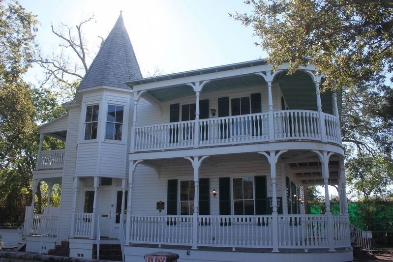 Xavier Lopez, descendant from a pioneer Minorcan family, succeeded as a merchant and public servant. He owned the house, passing it to his daughter upon his death. The house is significant as one of St. Augustine's best . . .
  Camp F-18 Savoy: located 2 mi W on FH222 at Rod & Gun Camp Companies: 756 -- 5/2/34 -10/15/34; 792 -- 5/15/35 - 10/17/35; 792 -- October 1940 - July 1941; summer 1941? The Civilian Conservation Corps was a federal relief . . .
  This building housed the local newspaper for one hundred years and is important for its association with Florida's first independent female editor Nina Hawkins. Architecturally, it is significant for the Italian Renaissance . . .
  Following its establishment in 1898, Dr. Edwin Lewis Stephens became the University's first president in 1900 at the age of 27. He transformed an empty sugar cane field into a respected institution of higher learning. On . . .
  Top section of marker: Old Glory I am the Star Spangled Banner..... conceived in 1777 out of love America bore for Liberty and Honor. I am the memorial of countless heroes who shed their blood to preserve this . . .
  The Farmington Canal crossed various topographic features- rivers, hills, roads and woodlands. Boats traveling the length of the canal passed through 28 locks that compensated for changes in elevation. Perhaps the most . . .
  This marks the center of the site where the tower of the Cape Cod Highland Lighthouse stood from 1857 until 1996
  For thousands of years before the Europeans landed, the Nauset Indians lived beside the marshes of Cape Cod. Among the evidence of their occupation is this community grinding rock, one of four such boulders found in the . . .
  Fifteen years before the Pilgrims landed on Cape Cod, French explorer Samuel de Champlain sailed down the Atlantic coast from Canada in search of new lands. On July 20, 1605, he entered here what was then a shallow bay. He . . .
  A Garden Protecting Rock Creek In 2011, the Friends of Pierce Mill partnered with the National Park Service to revive the plantings and install water sustainability features at this garden. These features include two rain . . .
  Forest Hills Neighborhood Art on Call Soapstone Valley Here the Nacotchtank Indians quarried soapstone and carved vessels. Archaeologist William Henry Holmes studied prehistoric workshops in this valley and other parts of . . .
  IEEE Milestone First Atomic Clock, 1948 The first atomic clock, developed near this site by Harold Lyons at the National Bureau of Standards, revolutionized timekeeping by using transitions of the ammonia molecule as its . . .
  Text on image: M. Belcher 2937 Macomb Street 11. Bungalow In the early 20th century, small apartment buildings and houses were constructed on Macomb, Ordway, Porter, Quebec, and Rodman Streets. Another popular style on . . .
  In the days before electronic navigational aids, the waters off Cape Cod with their hidden shoals held many dangers for passing ships, especially at night or during thick weather. In 1872 the U.S. Life-Saving Service . . .
  K-0010 is a column from the parking substructure area of the World Trade Center. These columns came from under WTC bldg. 6. K-0010 has remnants of red and blue paint, signifying the levels within the parking structure for . . .
  Plaza C del Complejo Calle de los Muertos Esta es la plaza más grande del Complejo Calle de los Muertos, con una superficie de 7,595.22 m2 se localiza en el extremo sur del complejo. En su zona central cuenta con un . . .
  1914 World War 1918 This Tablet Dedicated In Honor Of Our Brethren who Served Our Country During The Late War Roll Of Honor Oscar A. Beam · Charles W. Beardsley · Horace Chamberlain · George C. Coates · John N. . . .
  Plaza B del Complejo Calle de los Muertos Es la plaza central del Complejo Calle de los Muertos y la más pequeña, con una superficie de 3,723 m2: a diferencia de la A (Norte) y la C (Sur) ésta no cuenta con altar central. . . .


