Chesterfield Township, Michigan.
![]() Elisha Weller owned the land on which the school was situated for many years. In May, 1831, Elisha purchased three 80 acre parcels of farm land in Chesterfield from the United States Government. To date, the earliest records . . .
Elisha Weller owned the land on which the school was situated for many years. In May, 1831, Elisha purchased three 80 acre parcels of farm land in Chesterfield from the United States Government. To date, the earliest records . . .
(Education) Includes complete text, location, directions, 2 photos, GPS coordinates, map.
 Elisha Weller owned the land on which the school was situated for many years. In May, 1831, Elisha purchased three 80 acre parcels of farm land in Chesterfield from the United States Government. To date, the earliest records . . .
 (Education) Includes complete text, location, directions, 2 photos, GPS coordinates, map.
 In Commemoration of Sacajawea who guided Lewis and Clark through this the land of her childhood and capture On August 17th, 1805 she rejoined her tribe near this site. The services she rendered the expedition were . . .
 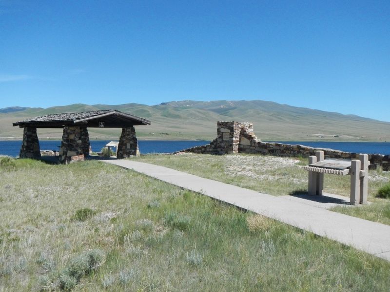 Few points along the route of the Lewis and Clark Expedition have the significance of this site, now beneath the waters of Clark Canyon Reservoir. Noted on their maps as "Fortunate Camp", the Lewis and Clark Expedition . . .
  This site was the pivotal point in the success of the Lewis and Clark Expedition. The party camped here in August 1805. They cached their boats and aided by the influence of Sacajawea obtained horses from her people the . . .
  Dette anker er rejst til minde om de mere end 2300 Danske søfolk som mistede livet under Anden Verdenskrig - 1939-1945. This anchor is placed in honour of more than 2300 Danish sailors who lost their lives during World War . . .
  In 1804-06, Captains Meriwether Lewis and William Clark led about 40 soldiers and boatmen on an epic journey. President Thomas Jefferson commissioned this “Corps of Discovery” to find a route to the Pacific Ocean through the . . .
  . . .
. . .  Victory Savings Bank, founded in 1921, was the first, and for many years the only, black-owned bank in S.C. It was chartered by I.S. Joseph as president and I.S. Leevy and C.E. Stephenson as vice presidents, and opened at . . .
  The Motte and Bailey Oxford Castle was built in 1071 by Robert d'Oilly who had accompanied William the Conqueror from Normandy to England in 1066. The Castie was surrounded by a moat from which material came to form both a . . .
  In 1905 disagreements over religious practices divided members of Columbia’s Tree of Life Synagogue. Jews embracing Orthodoxy formed a new synagogue, which they named Beth Shalom (House of Peace). Meetings were held in a . . .
  This home’s first owner was John R. Cornwell, an African American business man and civic leader who owned a successful barber shop on Main St. After his death, Cornwell’s wife Hattie and daughters Geneva Scott and Harriett . . .
  (side 1) The changing of global sea levels over millions of years was a major factor in determining the ancient geography of Minnehaha County. Through much of geologic time, salty warm-water seas covered the interior of the . . .
  Left Panel: This was once the site of Throop Hall, named after the founder of Throop University, Amos G. Throop. Throop University was founded in 1891 and became the California Institute of Technology in 1920. Built in 1910, . . .
  Oxford Castle dates from 1071 and stamped the authority of England's new Norman rulers on the town. It changed the layout of this area but incorporated an earlier watch-tower (c.1020) which became the tower of St George's . . .
  In 1883 members of Columbia’s Jewish community founded the Hebrew Cemetery Society of Columbia as an alternative to the Hebrew Benevolent Society’s cemetery, which had been established in 1822. The organization purchased a . . .
  Parroquia de San Mateo Apóstol Esta iglesia, cuya obra se inició en 1758 y se terminó en 1763 bajo la dirección del maestro de obras don Antonio Simón, se construyó a petición del Benefactor Don Manuel González Ponce de . . .
  In addition to its historic importance Blennerhassett Island also contains important prehistoric sites. Several Indian villages exist on the Island, and large collections of Indian artifacts have been found here. Largest of . . .
  New Road was new in 1770, built by a turnpike trust as a western exit from the city centre. It sliced through the former Oxford Castle bailey (the open space within the castle walls), providing an ideal site for what became . . .
  Near this place the Baptists of Oxford worshipped from 1661 to 1715 in the house of Richard Tidmarsh (minister 1661 – 1691). Baptisms took place in the stream below. The meeting-house was destroyed by rioters in 1715. . . .
  You are standing on Pacey's Bridge which crosses two branches of the Castle Mill Stream, itself a branch of the River Thames. The original bridge was constructed in 1770 when Park End Street and New Road were built as a . . .


