Bloomsburg, Pennsylvania.
![]() This property contributes to the Bloomsburg Historic District Placed on the National Register of Historic Places 1983
This property contributes to the Bloomsburg Historic District Placed on the National Register of Historic Places 1983
(Notable Buildings) Includes location, directions, 2 photos, GPS coordinates, map.
 This property contributes to the Bloomsburg Historic District Placed on the National Register of Historic Places 1983
(Notable Buildings) Includes location, directions, 2 photos, GPS coordinates, map.
 This property contributes to the Bloomsburg Historic District Placed on the National Register of Historic Places 1983
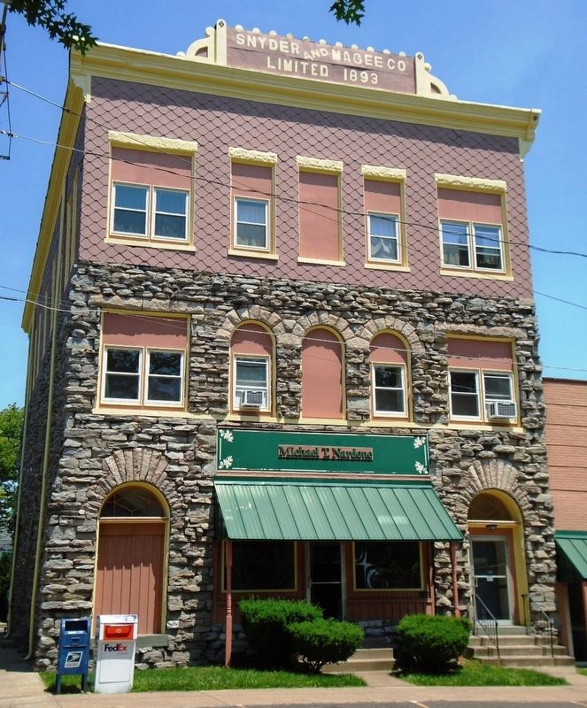
 Property of Special Merit Awarded by The Bloomsburg Historic Preservation Society
 This property contributes to the Bloomsburg Historic District Placed on the National Register of Historic Places 1983
 This property contributes to the Bloomsburg Historic District Placed on the National Register of Historic Places 1983
 This property contributes to the Bloomsburg Historic District Placed on the National Register of Historic Places 1983
 This structure was built as a bank in 1903. It replaced an earlier three-story brick building that was destroyed by fire in December 1902. The present building was designed by architect Clare Allen of Jackson and built by . . .
  . . .
. . .  Operated along with a mill by E. B. Smith during the Republic of Texas. Bought by John Spearman in 1850. At this site in 1870 the state authorized a toll bridge. Fees ranged from 2¢ for a sheep to $1 for an 8-horse team and . . .
  Comprised of various groups with distinct dialects and customs, the people known today as the Caddo once occupied a region that included parts of present Louisiana, Arkansas, Oklahoma and Texas as early as A.D. 800. By the . . .
  Ambrose Ripley and his wife Rachel (Wood) brought their family to Texas in 1837, settling near here in what was then Red River County. They established their home near the Nacogdoches Road (Cherokee Trace) and a stream now . . .
  Turkish Text: E6-8 no''lu çok odalardan olusan dükkânin sahipleri boya isleriyle ugrasmaktaydi. E6 ve E7 no''lu odalarda, tastan yapilma havanlar ile yeniden kullanilmis borular ve muhtemelern torbalar içine doldurulmus . . .
  Village of Ovid In 1836, inhabitants of Ovid, Seneca Falls County, New York, began to settle this fertile farm area. Among them were Samuel Barker, who built his log cabin in "Section 6;" Jabez Denison, noted for his prowess . . .
  Over eleven thousand years ago, groups of Native Americans started the long history of land use in this area. The Nez Perce Tribe carried on the rich tradition of hunting, fishing, and gathering food, herbs and wood. . . .
  The Riggins irrigation ditch was built in 1891 by early pioneers, Charlie Clay and brothers Isaac and Johnny Irwin, to supply water to their gold mining operation. By 1894, gold mining waned and the ditch was used for . . .
  If trees could talk, the big locust standing guard near the corner of Salmon Street might tell us all the details of the famous Gouge-Eye fight. It seems that Homer Levander and Big Markham got into a fight over comely Daisy . . .
  Early settler Charlie Clay, who operated a sheep ranch at Berg Creek, needed a better way to get his sheep across the river to the shearing plant located at the confluence of the Little Salmon and Salmon rivers. If the . . .
  Turkish Text: E5 no''lu dükkânin küçük olmasi ve içinde ilginç ev objelerinin bulunmasi, buranin bir mesken olarak kullanildigina isaret etmektedir. Fevkalade enteresan objeler arasinda, uzun adimlarla yürüyen aslan . . .
  Settled in Sutton County in early 1880's Walter E. married Mary Bell Martin to whom were born Emma Leanna-C. B. Wardlaw Charles Hadley (Tio)-Bachelor Walter Rowland (Lee)-Dora Davis Willie B. - Della Rose Halbert Francis . . .
  The Brundage House (photo top left) 301 South Main Street Built in 1918, the Scott Brundage home was one of the nicest of its time in Riggins. In 1927, the home was leased to the U.S. Forest Service and was eventually . . .


