Turkey, Nevşehir Province, Nevşehir (district), near Göreme![]() English:
English:
This is the oldest known rock-cut church in the region, and consists of four sections: the Old Church with one nave; the New Church; the Lower Church under the old church; and the Parecclesion to the north of the New Church.
The single-nave, barrel-vaulted Old Church, built in the 10th century, today acts as the entrance to the New Church. Its Apse collapsed when the New Church was added to the east wing. Frescoes are to be found on the vault and at the top of the walls. The life of Jesus is told on separate panels on the vault, running from left to right.
Scenes: Portraits of the saints are in the center of the vault. On the top panel of the right wing are Annunciation, Visitation, proof of the virgin, journey to Bethlehem, and nativity. On the top panel of the left wing are, adoration of the Magi, massacre of the innocents, flight into Egypt, presentation of Jesus in the temple and killing of Zacharias. On the middle panel of the right wing are, pursuit of Elizabeth, calling of St. John the Baptist, preaching of John, John meeting Jesus, baptism and marriage at Cana. On the middle panel of the left wing are, miracle of the wine, miracle of the loaves and fishes, calling of the Apostles, healing of the blind man and raising of Lazarus. On the lower panel of the right wing are entry into Jerusalem, Last Supper, betrayal and Jesus before Pilate. On the left lower panel of the left wing are Way of the Cross, crucifixion, descent from the cross, entombment, women at the tomb, anastasis and ascension. Beneath this panel are portraits of the saints, and transfiguration is painted over the entrance. The New Church is transversally rectangular with as simple barrel vault. On the east wall there are four columns joined by arches, behind which there is a raised corridor in front of the main apse and two side apses. On this barrel vaulted nave is the story of Jesus in chronological order in mainly bright red and blue colours. The dark blue color serves to distinguish the Tokalı Church from the other churches. On the transversal nave are scenes from the life of St. Basil. portraits of some saints and pictures of the miracles of Jesus. The church is dated back to last decade of the 10th century and the first decade of the 11th century.
Scenes: On the north wing of the vault are annunciation, visitation, proof of the virgin, nativity and adoration of the Magi. On the north wall of the vault are Joseph’s dream and journey to Bethlehem and below these in the niches are portraits of 8 saints. At the very bottom are calling of St. John the Baptist, John meeting Jesus, baptism, presentation of Jesus in the temple, calling of Matthew, calling of the Apostles and marriage at Cana; on the west wing flight into Egypt, temptation of Christ and Christ in the temple when twelve years old, on the south wing of the vault are the first diacons, pentecost and blessing and mission of the Apostles; on the south wall of the vault are some unidentified angels, below them, in the niches, are portraits of saints; at the very bottom are healing of the nobleman’s son, raising the daughter of Jairus, healing the paralytic, raising of Lazarus, entry into Jerusalem and Last Supper. On the west wing is washing of the disciples’ feet, on the main apse conch are crucifixion, descent from the cross, women at the tomb, anastasis, on the front wall of the apse are the first diacons and Jesus and the Samaritan woman; inside the niche is Mother Mary and baby Jesus; on the apse to the north is prophetic vision and angels.
Turkish:
Bölgenin bilinen en eski kaya kilisesi olup 4 mekandan oluşur. Tek nefli eski kilise, yeni kilise, yeni kilise, eski kilise’nin altındaki kilse, yeni kilise’nin kuzeyindeki yan şapel. 10. yüzyılın başlarına tarihelenen eski kilise, bugün yeni kilise’nin giriş mekanı şeklinde ise de orijinalde tek nefli, beşik tonozlu bir yapıdır. Doǧusuna yeni kilise’nin eklenmesi sırasında apsisi tamamen yıkınıştır. Sahneler tonoz yüzeyine ve duvarların üst bölümüne yerleştirilmiştir. İsa’nın hayatını kapsayan siklus tonozda panellere ayrılmış olup, sahneler saǧ kanatta başlayıp sol kanata doǧru birbirini takip etmektedir.
Sahneleri: Tonozun ortasında aziz tasvirleri, saǧ kanadında üst panelde; müjde ziyaret, bakireliǧin ispatı, beytüllahım’e yolculuk, doǧun, sol kanattaki üst panelde; üç müneccimin tapinmasi, masum çocukların katliamı, mısır’a kaçış, İsa’nın mabete takimi, zekeriya’nın öldürülmesı; saǧ kanattaki orta panelde; Elizabeth’nın takip edilmesi, vaftizci yahya’nın görevlendirilmesi, vaftizci yahya’nın kehaneti, İsa’nın vaftızcı yahya ile buluşması, vaftiz, hana düǧünü; sol kanattaki orta panelde şarap mucizesi, ekmeklerin ve balıkların çoǧalltılması, havarilerın görevlendirilmesi, kör adamın iyileştirilmesi, Lazarus’un diriltilmesi; saǧ kanattaki alt panelde; kudüs’e giriş , son akşam yemeǧi, ihanet, İsa platus önünde, sol kanattaki alt panelde; İsa golgota yolunda, İsa çarmıhta, İsa’nın çarmıhtan indirilmesi, İsa’nın gömülmesi, kadınlar boş mezar başında, İsa’nın cehenneme inişi, İsa’nın göǧe çıkışı, Bu panelin altında aziz tasvirleri; girişin üstünde ise başkalaşım sahnesi yer almaktadır.
Yeni tokalı enlemesine dikdörtgen planı, basit beşik tonozludur. Doǧu duvarında kemerlerle birbirine baǧlı dört sütun, sütunların arkasında yükseltilmiş bir koridor, koridordan sonra ana apsis ile iki yan apsis yer alır. Beşik tonozlu nefinde İsa’nın siklusu kronolojik sıraya göre daha çok kırmızı ve mavi renkler kullanılarak işlenmıştır. Lapis mavisi, tokalı kilise’yi diǧer kiliselerden ayıran en önemli özelliǧidir. enlemesine nefte, aziz Basil’ın hayatı, çeşitli azizlerin tasviri ve çoǧunluk İsa’nın mucizelerine ait sahneler yeralır. Kilise 10. yüzyılın sonuma ve 11. yüzyılın başına tarihlenmektedir.
Sahneleri: tonozun kuzey kanadına müjde, ziyaret, bakireliǧin ispatı, doǧum ve üç müneccimin tapınması, tonozun kuzey duvarında yusuf’un birinci rüyası, beytullahim’e yoculuk, altında nişler ićinde sekiz aziz tasviri, en altta ise vaftizci yahya’nın çaǧırılması, İsa’nın vaftizci yahya ile buluşması, vaftiz, İsa’nın mabete takdimi, matta’nın görevlendirilmesi, havarilerin görevlendirilmesi, kana düǧünü; batı kanadında mısır’a kaçış, İsa’nın denenmesi, İsa 12 yaşındayken mabette, tonozun merkezinde İsa’nın göǧe yükselişi ve havarilerin tanrı yolunda görevlendirilmesi; tonozun güney kanadında ilk diakonlar, ve havarilerin tanrı yolunda görevlendirilmesi; tonozun güney duvarında tanımlanamayan melekler, altında nişler içinde aziz tasviri, en altta ise zengin adamın oǧlunun iyileştirilmesi, jairus’un kızının iyileştirilmesi, felçlinin iyileştirilmesi, Lazarus’un diriltilmesi, kudüs’e giriş ve son yemek; batı kanadında ayakların yıkanmasi; ann apsiste İsa çarmıhta, İsa’nın çarmıhtan indirilmesi, kadınlar boş mezar başında, İsa’nin cehenneme inişi; ana apsisin ön cephesinde ilk diakonlar, İsa ve samarralı kadın, niş içinde meryem ve çocuk İsa; kuzey apsiste ise peygamberlerin görünümü ve melekler.
French: To read the French text, click on the marker image to enlarge it.
German: To read the German text, click on the marker image to enlarge it. (Churches, Etc.) Includes location, directions, 5 photos, GPS coordinates, map.
 English:
 The 1886 house and surroundings were an inspiration to this family. Brothers Frank and Eugene became prominent entomologists. Frank’s nationally known conservationist sons, John and Frank, Jr., saved Yellowstone’s grizzlies, popularized falconry, inspired the Wild and Scenic Rivers Act, and contributed to National Geographic. Newbery-winning daughter Jean Craighead George wrote nature books Julie of the Wolves and My Side of the Mountain
 English:
 The M109 series SP howitzer provided artillery support on the battlefield from Vietnam to the Global War on Terror. Introduced in 1963, the M109 retained the same chassis and turret as its predecessor, the M108 105mm SP howitzer, but boasted a 155mm cannon with muzzle break and fume extractor, and rear stabilization spades.
  Raised on a farm in Newville, Pennsylvania, Randall D. Shughart joined the Army after graduating from high school in 1976 and became a member of the elite Special Forces. During the Battle of Mogadishu, Somalia, SFC Shugart and his team leader Gary I. Gordon were providing sniper fire from the lead helicopter to support ground assault operations and covering two helicopter crash sites. When it became apparent that ground forces were not able to secure the area, both Soldiers volunteered to be inserted in to the second crash site, knowing that the crew lay wounded and that a large number of the enemy were approaching. The sniper team fought their way to the crash site, pulled the crew from the crashed helicopter and set up a security perimeter, putting themselves at the most vulnerable spots. Armed only with their sniper rifles and pistols they held off the enemy until their ammunition was depleted. Their action was directly responsible for saving the life of the pilot. For his selfless service that day SFC Shughart was posthumously awarded the Medal of Honor. Across the nation SFC Shughart’s service and sacrifice has been honored in different ways. His hometown named the Post Office after him and started a scholarship fund in his honor. The Army named a barracks and urban warfare training site after him and the Navy christened a ship the USNS Randall D. Shughart.
 In 1924 author, economist,
philosopher, Ralph Borsodi
and family designed and
began construction of this
homestead, utilizing native
field stone, their own
and semi-skilled labor.
By 1934 they completed
"Dogwoods" and an enclave
of five buildings. Here
they developed the "School
for Living" described in
"Flight from the City,"
Borsodi's acclaimed book
that inspired his Bayard
Lane, Van Houten Fields
developments in Rockland
and other back-to-the-land
communities nationally.
In 1924 author, economist,
philosopher, Ralph Borsodi
and family designed and
began construction of this
homestead, utilizing native
field stone, their own
and semi-skilled labor.
By 1934 they completed
"Dogwoods" and an enclave
of five buildings. Here
they developed the "School
for Living" described in
"Flight from the City,"
Borsodi's acclaimed book
that inspired his Bayard
Lane, Van Houten Fields
developments in Rockland
and other back-to-the-land
communities nationally.

 This place became the county seat when Craig County was formed in 1851. The courthouse was built in 1851 and remodeled in 1935. General Averell passed through New Castle in his raid of December, 1863, and General Hunter in June, 1864. The town was incorporated in 1890.
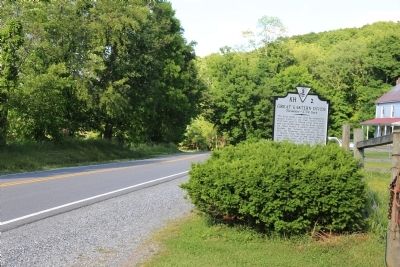 This point marks a spot along the geographical feature known as the Great Eastern Divide. From here water of Sinking Creek flows southwest into the New River. The New River, probably the oldest stream in eastern North America, becomes the Kanawha before joining the Ohio, the Mississippi, and eventually the Gulf of Mexico. From this spot water of Meadow Creek flows northeast to New Castle where it joins Craigs Creek, which in turn flows into the James River and ultimately into the Atlantic Ocean.

 Jacob A. Blauvelt and family,
the first of 7 generations of
Blauvelts to live on this farm,
occupied a log structure
nearby early in the 18th century. Jacob's son, Johannes J.
Blauvelt, built the sandstone
south unit of this home, circa
1755. The large central
section was added after the
Revolution, and the frame
north wing ca. 1862. This
396 acre farm extended west
to the Hackensack River.
Jacob A. Blauvelt and family,
the first of 7 generations of
Blauvelts to live on this farm,
occupied a log structure
nearby early in the 18th century. Jacob's son, Johannes J.
Blauvelt, built the sandstone
south unit of this home, circa
1755. The large central
section was added after the
Revolution, and the frame
north wing ca. 1862. This
396 acre farm extended west
to the Hackensack River. This Dutch farmhouse on
the northwest corner of
the Tappan Patent contains
late 18th and early 19th
century construction features.
Johannes (1743-1828) was
a charter member of the
Greenbush Church. His son
David (Dauvum) began the
county's first tobacco
business here. Abraham M.
(Gunsmith) Blauvelt repaired
watches and guns here
and rented boats on
Hackensack River in rear.
Blauvelts occupied premises
for 135 years.
This Dutch farmhouse on
the northwest corner of
the Tappan Patent contains
late 18th and early 19th
century construction features.
Johannes (1743-1828) was
a charter member of the
Greenbush Church. His son
David (Dauvum) began the
county's first tobacco
business here. Abraham M.
(Gunsmith) Blauvelt repaired
watches and guns here
and rented boats on
Hackensack River in rear.
Blauvelts occupied premises
for 135 years. This house stands on the
north half of lot No. 42
of the Kakiat Patent bought
from William Bayard by
Peter Perry c. 1773.
The earliest section of the
existing structure was
probably built by his son
Johannes c. 1774. It has been
enlarged and considerably
altered throughout the years.
In 1832 the farm was devised
to Johannes' daughter Mary,
wife of Abraham Horn[,] and
remained in the Horn family
until 1908.
This house stands on the
north half of lot No. 42
of the Kakiat Patent bought
from William Bayard by
Peter Perry c. 1773.
The earliest section of the
existing structure was
probably built by his son
Johannes c. 1774. It has been
enlarged and considerably
altered throughout the years.
In 1832 the farm was devised
to Johannes' daughter Mary,
wife of Abraham Horn[,] and
remained in the Horn family
until 1908. English:
 English:
 English:
 Miller’s place here was selected as the county seat of Botetourt in 1770. In 1772 the town of Fincastle was established on land donated by Israel Christian and named for Lord Fincastle, eldest son of Governor Lord Dunmore. It was incorporated in 1828. In 1845 it has a population of 700. Present courthouse was erected about 1850.


