Quebec, Montréal (region), Montréal![]() English:
English:
“Joe Beef’s may be low, it is certainly dirty on the cellar and ground floors; and the value of such a place to the city may be questioned, but let one thing be remembered - many a tired head has found rest; many a hungry mouth has been filled. Surely, this charity will cover a multitude of sins.” - Unknown - Montréal by Gaslight, 1889
A canteen keeper in the British army in the 1850’s, Charles “Joe Beef” McKiernan was assigned to the canteen on Île Sainte-Hélène in 1864 until he was discharged. He then opened Joe Beef’s Canteen, a tavern near Bonsecours Market that later moved to the corner of de la Commune et (and) de Callière streets in 1875. Bold, generous and flamboyant, the Irish immigrant quickly became the most famous tavern owner in Montréal.
The People’s Tavern
Hundreds of longshoremen, day labourers and seamen came to the canteen to drink and have lunch. For 10 cents, the wealthier clients had steak and onions, while the poorer patrons received a bowl of soup and some bread. The eccentric Joe Beef even kept a menagerie of wild animals in the cellar entertain guests!
The Friend of the Working Man
A man of the people, philanthropist Joe Beef generously offered food and lodging to sailors and vagrants. In 1877, he gave out 3,000 pieces of bread and some 2,000 liters of soup to striking Lachine Canal workers, whose cause he supported. When Joe Beef died in 1889, thousands of Montréalers attended his funeral. The Montréal Gazette dubbed him the “friend of the working man.”
Listen to our free self-guided tour,
5 Generations, One Port, via our wi-fi network!
French:
La cantine de Joe Beef est peut-être de bas étage, les planchers de sa cave et de sa salle sont certainement sales; la valeur d’un tel lieu pour la ville peut être mise en doute. Mais qu’on se souvenir d’une chose: plus d’une tête fatiguée a ici trouve le repos, bien des bouches affamées ont été ici remplies. Assurément, cette charité. Inconnu - Montréal by Gaslight, 1889
Cantinier dans l’armée britannique dans les années 1850, Charles Joe Beef McKiernan est affecté à la cantine militaire de l’île Sainte-Helene en 1864, jusqu’à sa décharge militaire. Il ouvre ensuite sa taverne, Joe Beef’s Canteen, Après du Marche Bonsecours, puis le déménage au coin des rues de la Commune et de Callière en 1875. Frondeur, généreux et flamboyant, cet immigrant irlandais devient rapidement le tavernier le plus connu de Montréal.
La Taverne du Peuple
Débardeurs, journaliers et matelots viennent à la «Canteen» par centaines pour y manger leur repas de midi et y boire. Pour 10 cents, les plus riches se paient un bifteck aux oignons, alors que les indigents sont gratifiés d’un bol de soupe avec du pain. L’excentrique Joe Beef garde même une ménagerie d’animaux sauvages dans sa cave pour divertir sa clientèle.
L’ami des ouvriers
Fils du peuple et philanthrope, Joe Beef offre généreusement nourriture hébergement aux sans-le-sou et aux marins. En 1877, il fournit 3 000 pains et quelque 2 000 litres de soupe aux ouvriers grévistes du canal de Lachine, et il soutient leur cause. À sa mort en 1889, des milliers de personnes assistent à ses funérailles et la Gazette de Montréal le surnomme «l’ami des ouvriers».
Consultez gratuitement notre autoguidé
5 générations, un port, sur notre réseau wi-fi!
(Charity & Public Work • Industry & Commerce • Labor Unions) Includes location, directions, 4 photos, GPS coordinates, map.
 the old Beechwold
Historic District
has been placed on the
National Register
of historic places
by the United States
Department of the Interior
1987
the old Beechwold
Historic District
has been placed on the
National Register
of historic places
by the United States
Department of the Interior
1987 Annie Oakley America's "Little Sure Shot" was born in northeastern Darke County, Ohio, and spent her childhood days in the house on this site. At that time the dense virgin forest surrounded her home and Annie shot and trapped wild game to help pay the debt on the property. By persistent priactice she became an expert shot and spent several years with Buffalo Bill's Wild West Show travelling extensively in America and Europe in whcih latter country she exhibited before crowned heads and she received a very enthusiastic reception. Eventually she became recognized as the champion lady rifle shot of the world and set a record for fancy and rapid shooting that may never be excelled by any woman. This tablete is placed by admiring friends. A.D. 1936
 in memory of
Abraham Brower
a pioneer
of
the Ohio Valley
1822- 1911
in memory of
Abraham Brower
a pioneer
of
the Ohio Valley
1822- 1911 At about 5:00 p.m. on July 9, 1864, the Confederates stormed the Union line on the Georgetown Pike. Union General Wallace ordered the withdrawal and chaos soon followed. With Confederates in hot pursuit, Union troops fled past Gambrill Mill, then through the field in front of you, and across Bush Creek behind you. After two miles the Confederates finally abandoned their chase.
 English:
 English:
 Segregated school located along the North Fork of the Blackwater that served Coketon, center of coal and coke empire of H. G. Davis. In 1892 teacher Carrie Williams, represented by J. R. Clifford, state’s first African Amerian lawyer, sued when county reduced school’s term. She won equal pay and terms for black students in WV. School closed in 1954.


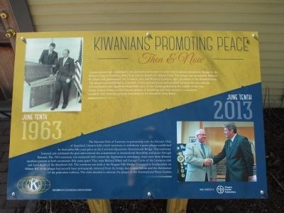 June tenth 1963. A peace plaque was established at the international boundary on the new Lewiston-Queenston Bridge by the Kiwanis Club of Lewiston, New York and the Stamford, Ontario Club. The plaque was unveiled by Richard H. Drake, left, president of the Lewiston club, and Robert J. Connon, right, president of the Stamford club. The plaque was established as a symbol of international peace and goodwill between the two nations. Kiwanis leaders and dignitaries from both sides of the border gathered in the middle of the bridge to bear witness to this historic gesture of friendship and were treated to a ceremony with speches, prayers, and music by the Salvation Army Band.
  This park is named after Father Louis Hennepin, a Beligian missionary who accompanied the French explorer Sieur de La Salle to this area in 1678. Hennepin, a Recollect priest, was not the first European to see Niagara Falls, but his colorful written accounts provided an opportunity for Europeans to read about Niagara Falls for the first time.
  In 1906. Carrie Nelson Black founded the Columbus Society for the Prevention and Control of Tuberculosis. now The Breathing Association. A woman ahead of her time, she volunteered as President and Chief Executive for thirty years, using her keen vision and marked executive ability. Mrs. Black also founded the instructive District Nurses Association (1898), Mother’s Day in Ohio (1911) and the Columbus Cancer Clinic (1921). the first free cancer clinic in the United States. She served as Director of the Ohio Society for the Prevention of Tuberculosis and initiated building of the first tuberculosis cottages, Open Air School, and Nightingale Cottage. Married to Probate Judge and Columbus Mayor Samuel L. Black, she was a pioneer and health crusader who spent her life in service to humanity. As a visionary and civic leader, Carrie Nelson Black had the ability to motivate others to share her passion to care for those less fortunate.
 Kimball (1844–1903) was Norfolk & Western’s second president and first chairman. Thanks to his leadership the railroad was headquartered in Roanoke and expended westward into West Virginia and Ohio.

 Come on, Georgians, follow me and we will show these (Confederate) cavalrymen how to fight.
 On the morning of July 9, 1864, John T. Worthington sent his family to safety in the cellar. From an upstairs window he watched Confederate General McCausland lead his cavalry brigade of 1,400 men into an ambush. Concealed behind a fence and waist high corn, 1,400 Union troops awaited the dismounted cavalrymen. As the cavalrymen drew closer, the Union line opened fire. They decimated the Confederates, who quickly fell back. Later in the afternoon McCausland launched a second attack and took the Thomas House. The outflanked Union line fell back to the Georgetown Pike, launched a counterattack, and drove the Confederates once more back to Worthington Farm.


