Ohio, Carroll County, Malvern
![]() Side A
Side A
The Great Trail
Gateway to the Ohio Country
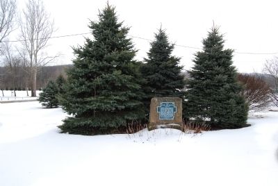
The ancient trail that passed near this spot was the major overland route entering the Ohio Country from the east through the 1700s. Also known as the Tuscarawas Path, the Great Trail was used by Native Americans, European explorers, fur traders, missionaries, military expeditions, land agents-and settlers after Ohio became a state. In January 1761, during the French and Indian War, Major Robert Rogers and thirty-eight rangers passed en route to Fort Pitt after taking Fort Detroit from the French. In 1764, during "Pontiac's Conspiracy," Colonel Henry Bouquet crossed here with an army of 1,500 men on his way to Goshachgunk (Coshocton), where he treated with the Delaware and freed captives. During the American Revolution, the Continental Army under General Lachlan McIntosh camped here for two days in November 1778.
Side B
The Ohio Country in the Revolution The western wilderness that later became the state of Ohio played a major role in American, British, and Native American strategy during the American Revolution. In 1778, General George Washington ordered General Lachlan McIntosh to establish a new fort in Ohio to provide a base for a spring campaign on Fort Detroit, held by the British and allied tribes. That fall McIntosh set out from Fort Pitt with over 1,200 troops. On the nights of November 13 and 14, 1778, McIntosh's expedition camped at this site. They subsequently joined forces with friendly Delawares and proceeded west to the Tuscarawas River, where they fulfilled their mission by establishing Fort Laurens. Located at present-day Bolivar, it was the only Continental Army fort built in Ohio during the Revolution.
(Forts, Castles • Native Americans • War, US Revolutionary) Includes location, directions, 4 photos, GPS coordinates, map.
 Side A
The Great Trail
Gateway to the Ohio Country
The ancient trail that passed near this spot was the major overland route entering the Ohio Country from the east through the 1700s. Also known as the Tuscarawas Path, the Great Trail was used by Native Americans, European explorers, fur traders, missionaries, military expeditions, land agents-and settlers after Ohio became a state. In January 1761, during the French and Indian War, Major Robert Rogers and thirty-eight rangers passed en route to Fort Pitt after taking Fort Detroit from the French. In 1764, during "Pontiac's Conspiracy," Colonel Henry Bouquet crossed here with an army of 1,500 men on his way to Goshachgunk (Coshocton), where he treated with the Delaware and freed captives. During the American Revolution, the Continental Army under General Lachlan McIntosh camped here for two days in November 1778.
Side B
The Ohio Country in the Revolution The western wilderness that later became the state of Ohio played a major role in American, British, and Native American strategy during the American Revolution. In 1778, General George Washington ordered General Lachlan McIntosh to establish a new fort in Ohio to provide a base for a spring campaign on Fort Detroit, held by the British and allied tribes. That fall McIntosh set out from Fort Pitt with over 1,200 troops. On the nights of November 13 and 14, 1778, McIntosh's expedition camped at this site. They subsequently joined forces with friendly Delawares and proceeded west to the Tuscarawas River, where they fulfilled their mission by establishing Fort Laurens. Located at present-day Bolivar, it was the only Continental Army fort built in Ohio during the Revolution.
(Forts, Castles • Native Americans • War, US Revolutionary) Includes location, directions, 4 photos, GPS coordinates, map.
 Planned in 1827 as an important trade route between Glasgow on the Ohio River, to the Ohio Canal at Bolivar, passed here. A basin and toll station were located nearby at Lodi, as well as Locks 19 and 20 and a canal dam. This segment of the Western Division was completed in 1845, and saw regular service between Hanover and Bolivar until 1853. The coming of the railroad and recurring floods caused its abandonment.
 Side A
 Side A
 Bertha Martin founded the Young People's Christian Association (YPCA) in 1916 and later served as secretary of the YWCA until 1937.
 Purchased in 1878, this bell was installed at the central engine house on the northeast corner of Charles Avenue and Park Row Southeast. In 1895, it was moved to the tower of the next city's central firehouse at the northeast corner of Charles and City Hall Street Southeast (photo. When the bell cracked, it was recast in Baltimore in 1930 and returned to the tower until 1952, when the tower was removed.
 Side A
 Organized in 1884, the Methodist congregation at Clyde met in private homes until their first church building was erected on this site in 1904. The white frame structure was replaced in 1936 by this sanctuary, built of stone donated by church members. Featuring elements of the English Gothic style, the one-story rough-rock sanctuary boasts a steeply-pitched roof, pointed-arch window at the gable end, and a round-arched entry.
 Settlers began moving to this area when the Texas and Pacific Railroad completed its line in December 1880. Many located near the commissary of railroad crew foreman Robert Clyde, for whom the town is named. A post office was established in 1881. The schoolhouse was used for church meetings and local court proceedings. A sign on the water town in 1920 proclaimed Clyde “The California of Texas” because of its fertile soil and shallow water table. On three separate occasions, in 1895, 1938 and 1950, destructive tornadoes have hit the community.
 Typically Victorian in style. Built in 1906 by Frank X. Prew, who emigrated from Wisconsin in 1889, desiring to live in a young country. He began a small farm and worked on railroad.
 On this location 11,000 years ago, at the end of the Ice Age, there existed a large encampment of early Paleoindian hunters. They were the first inhabitants of Ohio. The 25-acre Nobles Pond archaeological site is one of the largest Clovis Paleoindian sites in North America. It documents how these early people obtained raw materials, made and used tools, and lived their daily lives. The Nobles Pond site was excavated largely by local volunteers to preserve this important part of our common heritage.
 In honor of those who paid the price of freedom
 Beginning in the early 1500s and continuing for more than three centuries, about 12 million African were transported across the Atlantic Ocean into slavery, in what has come to be known as the Middle Passage—the largest forced migration in history. About 2 million died during the voyage and approximately 500,000 were delivered directly to the North American mainland.


