Quantcast
Channel: The Historical Marker Database - New Entries
Viewing all 103809 articles
Browse latest View live

Saint Vincent

$
0
0
Pennsylvania, Westmoreland County, near Latrobe
Founded in 1846 by Boniface Wimmer on the site of a Catholic parish built in 1789, Saint Vincent Archabbey, College, and Seminary was the first institution in the US established by monks of the Order of Saint Benedict. The college was incorporated by the Commonwealth of Pa. in 1780 to provide both undergraduate and graduate education in the liberal arts and sciences. Ten abbeys and colleges in eight states trace their roots to Saint Vincent.

(Churches, Etc. • Education) Includes location, directions, 3 photos, GPS coordinates, map.

Fire and Brick & Stone

$
0
0
Arkansas, Carroll County, Eureka Springs

The neighborhood above the current First Baptist Church burned in the Great Fire of 1883, the first of four Great Fires which destroyed most of the town's early wooden structures. New commercial buildings were built of more fire-resistant materials such as brick and limestone. This block, originally called Rice Avenue, is one of the most interesting downtown. Beautiful spring parks anchor both corners.

[Inset photo captions read]
[1.] The Wadsworth Building was the first structure to rise from the ashes after the second Great Fire in 1888. This multi-story building was a popular home furnishings and hardward store whose ghost signs still give hint to the wide variety of merchandise offered by various owners. This view also shows the foundations of the "new" U.S. Post Office, completed in 1918.

[2.] Originally the site of the Kentucky House, the Sharp's Continental Oil Filling Station was located here in 1928 to provide convenient service to the automobile tourist. It was enlarged and converted to law offices in 1964.

[3]. The Sweet Spring Hotel once stood here. It was built in 1887 and later became the Huntington Hospital. It burned in the 1940s and site was vacant until the current building was constructed to blend well into the corner in 1994.

The unique Palace Bath House sign is said to be the first neon sign west of the Mississippi River, designed by colorful local sign artist By Golly.

In the Neighborhood
Limestone
: Sweet Spring is a good place to see the many ways this rock forms the basic fabric of Eureka Springs; natural bluffs, cut stone stacked walls, sidewalks, benches and buildings!

The Sweet-Harding Spring Reservation: Public land set aside in the 1890s, it is above the entire block to protect the springs. A rustic trail leads to Harding Spring on the next corner.

Upper Spring Street: A lovely flat walk with beautiful spring parks and interesting buildings built into the mountainsides.

First Baptist Penn Memorial Church: Built 1916 and named in honor of Major William Penn, an evangelist and minister in Eureka Springs.

Landmarks [Map and Key]

This material is based upon work assisted by a grant from the U.S. Department of the Interior, National Park Service, a Preserve America grant. Any opinions, findings, and conclusions or recommendations expressed in this material are those of the author and do not necessarily reflect the views of the Department of the Interior. Photographs courtesy of the Cornerstone Bank of Eureka Springs, Eureka Springs Historical Museum and the Eureka Springs Carnegie Public Library.

(Disasters • Industry & Commerce • Man-Made Features • Settlements & Settlers) Includes location, directions, 6 photos, GPS coordinates, map.

Right Reverend Boniface Wimmer, O.S. B.

$
0
0
Pennsylvania, Westmoreland County, near Latrobe
PAX
Right Reverend Boniface Wimmer, O.S.B.
Founder of the Benedictine Order in the United States,
Archabbot of St. Vincent,
First President of the American Cassinese Congregation,
Born at Thalmassing, Bavaria, January 14, 1809,
Died at St. Vincent, December 8, 1887
I.O.G.D

(Notable Persons) Includes location, directions, 3 photos, GPS coordinates, map.

Site of Sportsman's Hall Log Cabin

$
0
0
Pennsylvania, Westmoreland County, near Latrobe
Which served as the first Catholic Parish Church of western Pennsylvania. The property was bought by the Reverend Theodore Brouwers, O.F.M. First pastor of the congregation, April 16, 1790.

(Notable Buildings) Includes location, directions, 2 photos, GPS coordinates, map.

Sweet Spring Hotel - Huntington Infirmary - Sweet Spring Home

$
0
0
Arkansas, Carroll County, Eureka Springs

Sweet Spring Hotel
The Sweet Spring Hotel was established about 1887 at the corner of Pine Street and Spring, then known as Rice Street, with A.S. Capps as proprietor. The spacious three-story frame structure was painted white with dark trim color accenting the simple decorative details of multiple large windows and verandahs. The glass-enclosed dining room and parlor conservatory for guests occupied a two-story wing.

The hotel was situated adjacent to the Sweet Spring and publicized its central location. A directory of 1900 date claimed "table service best of the market, electric cars at the door, rates $1 per day". T.J. Brumfield succeeded Capps as proprietor until 1913 when Robert H. Huntington, a medical specialist from Mississippi and son-in-law of Festus Orestes (F.O.) Butt, long-time Eureka Springs attorney (from 1897-1971), acquired the building. The doctor equipped the building with the latest innovations for treatment of patients, including an operating room, and established Huntington Infirmary, the city's first modern hospital.

Huntington Infirmary
The hospital was fitted with the latest modern equipment and the building provided a light and well-ventilated environment for convalescents. Several local doctors made use of the facility including Pace, Bolton, Albert and Pearl Tatman and J.F. John. Dr. Huntington closed the infirmary in 1929 as it was no long self-sustaining financially. That same year a community-wide effort resulted in the opening of the Don Sawyer Hospital, forerunner of the present facility.

The compassionate purpose of Huntington Infirmary was best symbolized by two carved stone figures which flanked the stair steps at the entry beside Spring Street: a lion and a lamb lying side by side, symbols of a peaceable kingdom where suffering and want could no longer be found.

Sweet Spring Home
New owner, Mrs. Arch Kimberling, reopened the structure as a residential hotel in 1930. The building fell victim to fire in the early 1940's and the site remained vacant for more than half a century, until the existing building was constructed in 1994 by Charles and Janet Epley to house Carroll County Abstract & Title Co.

(Industry & Commerce • Man-Made Features • Science & Medicine • Settlements & Settlers) Includes location, directions, 4 photos, GPS coordinates, map.

Sweet Spring

$
0
0
Arkansas, Carroll County, Eureka Springs

This spring derived its name from early townspeople who declared the water to have a pleasant, sweet taste. The spring was originally located in the deep ravine below the present site. A long wooden stairway led from the spring to the narrow wagon road then known as Rice Street, which is now called Spring Street. Sweet Spring was also referred to as Spout Spring.

Around 1885 workmen dug into the mountainside above the street to locate the stream of water in a more accessible location. A stone lined circular enclosure around the spring, and finely pointed limestone walls were constructed against the hillside. The Waldrip brothers, William, James and John, were the skilled stonemasons who performed this work.

When Spring Street was widened, a small public area adjacent to the spring was set aside. Wide boardwalks and wood benches were built. A long wooden stairway led to a pathway and a street above the spring.

In 1916 the Waldrip brothers built a stone stairway inset with benches to replace the old wood steps. The Eureka Springs Women's Club funded these improvements, along with many other community beautification projects. A.O. Clark, who later designed the auditorium in 1928, was the architect for this project.

Sweet Spring and the wooded area above and below it were established by Ordinance No. 77 dated February 15, 1886 as a spring reservation, preserved for public use in perpetuity.

(Charity & Public Work • Environment • Man-Made Features • Settlements & Settlers) Includes location, directions, 5 photos, GPS coordinates, map.

Prehistoric Indian Mound

$
0
0
California, Alameda County, Alameda
One thousand feet due west was a prehistoric mound, 400 feet long, 150 feet wide, and 14 feet high. The remains of 450 Indians with stone implements and shell ornaments were found when the mound was remove in 1908.

(Native Americans) Includes location, directions, 3 photos, GPS coordinates, map.

Meyers House

$
0
0
California, Alameda County, Alameda
The Meyers House was erected in 1897. This Colonial Revival style home was designed by and built for prominent East Bay architect Henry H. Meyers. It served as the family residence from 1897 to 1993.
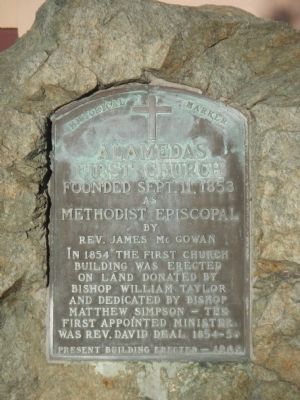
Meyers designed the Posey Tunnel Portals, Twin Towers Methodist and First Presbyterian Churches, Alameda Veterans Building, and numerous buildings throughout the Bay Area.

(Notable Buildings) Includes location, directions, 3 photos, GPS coordinates, map.

Alameda’s First Church

$
0
0
California, Alameda County, Alameda
as
Methodist Episcopal
by
Rev. James McGowan
In 1854 the first church building was erected on land donated Bishop William Taylor and dedicated by Bishop Matthew Simpson - the first appointed minister was Rev. David Deal, 1854-56.
Present building erected - 1909

(Churches, Etc.) Includes location, directions, 3 photos, GPS coordinates, map.

Alameda Lodge No. 1015

$
0
0
California, Alameda County, Alameda
Alameda Lodge No. 1015 of the Benevolent and Protective Order of Elks was formed by 25 Alameda residents who were members of Oakland Lodge No. 171. The Lodge was instituted on March 17, 1906 and it received its charter from the Grand Lodge on July 20, 1906. The original Lodge building which the members built on September 27, 1908, still stands behind the southeast corner of this building. This current Lodge building was designed by Lodge member Charles E.J. Rogers, Exaulted (sic) Ruler W.O. Smith laid the cornerstone on October 17, 1909.

Inside the cornerstone is a brass box containing Lodge artifacts from the period the building was dedicated on May 15, 1910. Thomas Lennon, later Justice of the California Supreme Court, delivered the dedicatory oration. The members held their first regular meeting in the Lodge room the next day.

One unique feature of the building is the Tiffany glass dome in the Lodge Room on the upper floor. The dome depicts an Elk superimposed on a clock set at 11 o’clock, the time at which Elks recall and toast to their absent members.

(Fraternal or Sororal Organizations) Includes location, directions, 3 photos, GPS coordinates, map.

Hoffman House

$
0
0
California, Orange County, Fountain Valley
The Hoffman family arrived here about 1910. A son Ed and his wife Elsa were very active during the City incorporation. Many meetings and City business were conducted in their home.

(Notable Places • Settlements & Settlers) Includes location, directions, 1 photo, GPS coordinates, map.

Duty~Honor~Country

$
0
0
California, Kern County, Tehachapi
The Sacrifices of few ensured the freedom of many. A grateful community remembers those who served in the Armed Forces of the United States during time of war and peace, whose courage and personal sacrifices defended and preserved our freedom.

(Military) Includes location, directions, 4 photos, GPS coordinates, map.

The Crescent Hotel & Spa

$
0
0
Arkansas, Carroll County, Eureka Springs

May 20, 1886...
America's newest and most luxurious hotel built at a cost of $294,000.

It was two years ago that Powell Clayton and his associates chose the site of the new Crescent Hotel... twenty seven acres at the north end of West Mountain, a majestic location overlooking the valley. The commissioning of Isaac S. Taylor as architect was announced and construction commenced. Special wagons were constructed to transport the huge pieces of limestone from the quarry site on White River near Beaver. Mr. O'Shawnessey, the spokesman of the imported group of Irish masons predicts, "The eighteen inch thick walls of the Crescent, fitted without the use of mortar, would withstand the destructive forces of time and retain its original beauty for many years to come." The property is lighted with Edison lamps, furnished with electric bells, heated with steam and open grates, has a hydraulic elevator, and is truly a showplace of today's conveniences.
- Eureka Springs Echo

The article above announced the opening of the wonderful resort. The Crescent Hotel today, recognized as one [of] the few historic hotels of America[,] has undergone several personalities, including the operation of a seasonal girls school, the Crescent College and Conservatory and that of a cancer hospital from 1937-1939. In 1997 however, Martin and Elise Roenick saved the hotel from a sad decline and initiated an aggressive restoration project to recapture the elegance, protecting the irreplaceable. Marty Roenick so perfectly described at the time of purchase his goal[,] "Elise and I have a vision to take the Crescent Hotel in five years to where it was nearly a century ago." In 2002, this feat has been accomplished as the Crescent Hotel has reopened to its full capacity for the first time in over 75 years.

(Entertainment • Industry & Commerce • Man-Made Features • Settlements & Settlers) Includes location, directions, 3 photos, GPS coordinates, map.

Avarana

$
0
0
Arkansas, Carroll County, Eureka Springs

Resort home built 1899 by William Henry Reid of Chicago. Architect Theodore C. Link of St. Louis. design reflects simplicity favored at end of Victorian era. Upper floors are wood with verandas on four sides. Lower floor is Beaver Limestone. In 1892, Reid donated a central school named in his honor.
———————————
This property
has been placed on the
National Register
of Historic Places

by the United States
Department of the Interior

Arkansas Historic Preservation Program

(Notable Buildings) Includes location, directions, 3 photos, GPS coordinates, map.

Swatting Mosquitoes

$
0
0
Florida, Escambia County, near Pensacola Beach
Isolation and boredom, snakes and biting flies—many of the soldiers stationed at Fort Pickens in the 1800s and 1900s felt they had been sent to the end of the Earth and forgotten. They spent hours on end in the sweltering sun standing watch, conducting artillery drills, maintaining equipment, and swatting mosquitoes. In their leisure time they played cards read letters and newspapers sent from home, swam in the gulf, fished, and played ball games. Some of them even hunted alligators despite official prohibitions.

(Forts, Castles • War, World I) Includes location, directions, 4 photos, GPS coordinates, map.

Site of the First Wood-Spaulding Saw Mill

$
0
0
Wisconsin, Jackson County, Black River Falls
Site of the First Wood-Spaulding
Saw Mill 1839-40
That Marks Founding of City
Jackson Co. Hist. Soc. 1939

(Industry & Commerce • Settlements & Settlers) Includes location, directions, 4 photos, GPS coordinates, map.

Grotto Spring

$
0
0
Arkansas, Carroll County, Eureka Springs

The words "esto perpetua" emblazoned upon a stone above the entrance to Grotto Spring declare the prevailing belief that these healing waters would flow forth forever. Early townspeople discovered the spring under an overhanging rock ledge, a short distance from the well-known Dairy Spring.

Extensive street construction on "The Boulevard", as Spring Street was then called, began in 1890. This necessitated construction of an enclosure of limestone and ornamental stonework hand-worked by very skilled stonemasons. Grotto Springs [sic - Spring] was located only a few steps from the electric streetcar line.

Some of the first ordinances enacted by city government were to protect the springs for public use in perpetuity. The wooded area on the hillside above and around the spring is delineated by ordinance that appears to be Oak or Sheffield Spring described in Ordinance No. 81, dated February 15, 1886. The Sheffield family resided nearby in 1880 and may have operated the original dairy for which the hollow below this site was named.

(Charity & Public Work • Environment • Man-Made Features • Settlements & Settlers) Includes location, directions, 6 photos, GPS coordinates, map.

Teddy Roosevelt's Bear Hunt

$
0
0
Mississippi, Sharkey County, Rolling Fork
Pres. Theodore Roosevelt came to Smedes, 2 mi. S, in 1902 to hunt. On Nov. 14, Roosevelt refused to shoot a captive bear. Cartoons of the event are though to have led to the creation of the "Teddy Bear."

(Animals • Environment • Notable Persons • Sports) Includes location, directions, 8 photos, GPS coordinates, map.

Muddy Waters

$
0
0
Mississippi, Sharkey County, Rolling Fork
~Front~ McKinley Morganfield, better known as Muddy Waters, was one of the foremost artists in blues history. In the late 1940s and 1950s he led the way in transforming traditional Delta blues into the electric Chicago blues style that paved the road to rock 'n' roll. Waters was born in the Jug's Corner community of rural Issaquena County but always claimed Rolling Fork as his birthplace. His birth date has been cited as April 4, 1913, 1914, or 1915.
~Back~ McKinley Morganfield's grandmother, Della Grant, nicknamed him “Muddy” because, as a baby on the Cottonwood Plantation near Mayersville, he loved to play in the mud. Childhood playmates tagged on “Water” or “Waters” a few years later. His father, Ollie Morganfield, was a sharecropper in the Rolling Fork area who also entertained at local blues affairs. But Waters was raised by his grandmother, who moved to the Stovall Plantation near Clarksdale when he was still a young child, and his influences were Delta musicians such as Son House, Robert Johnson, and Robert Nighthawk. Muddy first played harmonica with Stovall guitarist Scott Bohanner, but took up guitar under the older musician's tutelage, and later performed with another mentor, blues legend Big Joe Williams. He also played in a string band, the Son Sims Four, and drove a tractor on the Stovall Plantation, where he ran a juke joint out of his house.

Waters did his first recordings at Stovall in 1941-42 for a Library of Congress team led by Alan Lomax and John Work III. In 1943 he moved to Chicago, and by the end of the decade he was setting the pace on the competitive Chicago blues scene. The city was loaded with freshly arriving talent from Mississippi, Arkansas, and Louisiana as southern farm workers continued to migrate to the alleged “promised land” of the north. Many of the finest musicians, including harmonica player Little Walter Jacobs, pianist Otis Spann, and guitarist Jimmy Rogers, worked in the seminal Muddy Waters Blues Band, which virtually defined the Chicago blues genre. Both through his recordings on the Aristocrat and Chess labels and through his sensual and electrifying live performances, he not only became a blues icon but a godfather to generations of rock 'n' roll bands, as he expanded his audience from the African American clubs of Chicago's South and West sides to Europe and beyond. The Rolling Stones recorded several of his songs and took their name from one of his early records, “Rollin' Stone.” Jazz, R&B, country & western, and hip hop artists have used his material as well.

Other Muddy Waters classics, many written by Vicksburg native Willie Dixon, include “Got My Mojo Working,” “Manish Boy,” “I Just Want to Make Love to You,” “Hoochie Coochie Man,” and “I'm Ready.” Waters returned to visit or perform in Mississippi on occasion, and appeared at the Greenville V.F.W., the Ole Miss campus, and the 1981 Delta Blues Festival. A recipient of multiple Grammy awards, charter member of the Blues Foundation’s Blues Hall of Fame, and 1987 inductee into the Rock and Roll Hall of Fame, Muddy Waters died in his sleep on April 30, 1983, at his home in Westmont, Illinois.

(African Americans • Arts, Letters, Music • Entertainment) Includes location, directions, 9 photos, GPS coordinates, map.

Misery

$
0
0
Maryland, Prince Georges County, Capitol Heights
In the stifling heat on August 24, 1814, British soldiers struggled to keep up their march. They rested at Addison Chapel prior to that afternoon’s battle at Bladensburg.

Despite an altered roofline, chapel resembles the 1809 structure seen by the British. Benjamin Stoddert, first U.S. secretary of the navy, is buried there.

Surprise Switch
The British brought few horses and picked up others along the way. Tradition holds that a British sympathizer on a fine horse greeted British officers resting at Addison Chapel. To his surprise, they took his horse and sent him off on a worn-out hack.

“The sun…now beat upon us in full force; and the dust rising in thick masses from under our feet…flew directly into our faces…”
-British Lt. George Robert Gleig.

(Inscription beside the image in the center)
Weary from days of marching, the British troops rested when they had a chance.

(War of 1812) Includes location, directions, 2 photos, GPS coordinates, map.

Viewing all 103809 articles
Browse latest View live


Latest Images