Ohio, Mahoning County, Youngstown![]() Side A
Side A
Crandall Park is the heart of the historic district and includes Fifth Avenue, Redondo Road, Catalina Avenue, and Tod Lane. Most of the district’s historic structures were built between 1904 and 1930, Youngstown’s heyday as an urban and industrial center. The district encompasses 92 houses, 32 outbuildings, a pavilion and rustic stone shelter in Crandall Park, and the concrete arch bridge carrying Fifth Avenue over the park. The North Heights Land Company and the Realty Guarantee Trust Company developed much of the neighborhood. Homes in the district were built for the city’s prominent industrialists and businessmen. The houses feature the work of architects Morris Scheibel, Charles F. Owsley, Fred Medicus, Barton Brooke, and Cook and Canfield and are distinguished by their grand scale, high-style design, spacious lots, landscaping, and orientation to the park or boulevard roads.
(Continued on other side)
Side B
(Continued from other side) Houses in the district exhibit a variety of styles: English Revival, Colonial Revival, Arts and Crafts, Spanish Colonial Revival, American Four-Square, and Chateauesque. The house at 1411 Fifth Avenue, built in 1904, is the earliest house in the district and displays elements of both the English Revival and Craftsman-styles. Oak Manor, at 1508-1510 Fifth Avenue was built around 1905 and later inhabited by Thomas Bray, president of Republic Iron and Steel Co. Other prominent residents of the district included Frank Purnell, Youngstown Sheet and Tube’s president, Edward Clark, Newton Steel’s president, George Brainard, General Fireproofing’s president, state representative and attorney William R. Stewart, and Philip Wick, Myron Arms, Charles Schmutz, Almon Frankle, Joseph Schwebel, Bert Printz, and Joseph Lustig.
(Notable Places) Includes location, directions, 5 photos, GPS coordinates, map.
 Charloe
site of
Oquanoxa’s Indian
Reservation
before 1820
Charloe
site of
Oquanoxa’s Indian
Reservation
before 1820 African-Caribbean, born in St.Marc, Haiti
 Dedicated to the young men of
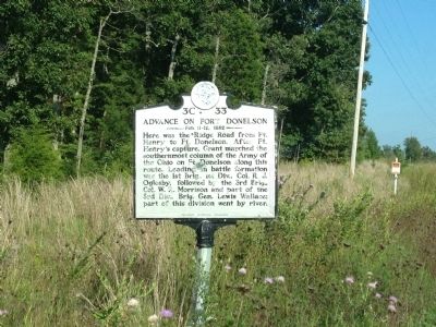 Here was the "Ridge Road" from Ft. Henry to Ft. Donelson. After Ft. Henry's capture, Grant marched the southernmost column of the Army of the Ohio on Ft. Donelson along this route. Leading in battle formation was the 1st Brig., 1st Div., Col. R.J. Oglesby, followed by the 3rd Brig., Col. W.R. Morrison, and part of the 3rd Div., Brig. Gen. Lewis Wallace; part of this division went by river.
 About 300 yds. upstream was a ford over which this road formerly crossed. Here, following a council of war in which he had refused to consent to the Confederate surrender, Col. Nathan Bedford Forrest led his regiment unopposed out of the position. The ford was then flooded. He was followed by numerous artillery and infantry stragglers from other units.

 Founded 1929 by Lucy Morgan (1889-1981) to promote traditional crafts including pottery, metal-working, and weaving. Campus 1 mile S.W.
 A hamlet settled in the late eighteenth century by free blacks and whites. The Hosanna School built in 1867, was Harford County's first public school for African Americans. Travelers, local farms, and industries such as milling, mining, quarrying, and canning were served by the Conowingo Toll Bridge (1818), The Susquehanna and Tidewater Canal (1839), and the Berkley Road. Part of the principal route between Baltimore and Philadelphia until the opening of the Conowingo Dam and relocation of US 1 in 1928
 In the late 1800’s the railroad pushed further west into Gadsden County. In 1897, the Humphrey Company established a settlement. The company, owned by W.P. Humphrey, dealt in land, timber, and general merchant services of the time. When Gretna was platted as a town in 1905 there was a desire to have a school in the town limits. In 1908, Mr. Humphrey along with his wife Sarah M. Humphrey and J.W. Mahaffey and his wife Addie Mahaffey, deeded the land for the school to the Board of Public Instruction for $100. R.A. Gray, who later became Florida’s longest serving Secretary of State, was a principal here from 1910-1911. The building served as a school until 1935 and stands today with only minor changes from its original design. It consists three rooms on the first floor and one great room upstairs with a stage on the south side. The school has since been used as a health clinic, town hall, community center, and for church-related activities. Many lives have been touched by this building and we the trustees of the W.P. Humphrey Club, A. Walter Watson, Jr., W.A. Johnson, and Sterling L. Watson are honored to preserve for future generations this monument of our past.
 Fort Braden was established in 1839 as a military outpost during the Second Seminole War (1835-1842). At the end of the war the fort was abandoned, but the small farming community that had developed nearby continued. A school in the Fort Braden area was first mentioned in an 1847 Tallahassee Floridian article reporting tax collections at the Fort Braden schoolhouse. Early education in rural Leon County was provided at small, one-room schools. The education these schools offered was inferior to that of urban areas. Yet over the next 80 years, many of these schools were built in Fort Braden and around the county. Consolidation of the schools was proposed at the turn of the 20th century, but did not start until the 1920s when motorized school buses and improved roadways made it possible to transport students to a centralized location. In 1926, the four-classroom Fort Braden School was constructed, featuring an inset entrance and double doors with molded accents. The school served as an education facility and community center for the next 66 years until 1993 when the new Fort Braden School replaced it. Today, the Old Fort Braden School continues to serve the citizens of Fort Braden as a community center.
 The Dezell House was built in 1912 by James A. and Margaret Leila Maggie Shepard Dezell. This house, with its Prairie Style architecture and Arts and Crafts features, was their family home for 46 years. James A. Dezell (1867-1937) was born in Chicago, moving from southwestern Missouri to Gadsden County in 1886. James and Maggie, a Gadsden County native, married on September 13, 1893. Between 1894 and 1903 they had three sons and two daughters. James and his father, Samuel A. Dezell, were builders. They constructed the Samuel Dezell family house in Mt. Pleasant in 1886. James A. Dezell was the first mayor of the Town of Greensboro, serving several terms following the first organizational meeting on August 13, 1908. The most distinctive aspects of this houses construction are its closeness to the ground rather than sitting on piers, fine craftsmanship, and windows set in dormers that crown the roofline on each main roof slope and provide light for a skylight in the entry hall. Dezell was evidently very confident in materials and techniques he chose for the house.
 Settlers in the new U.S. territory of Florida (created in 1821) who were members of the Masonic order soon established lodges in their new communities. Washington Lodge No. 2, Free and Accepted Masons, created in 1828 was among the first Florida lodges. A Masonic building constructed in 1832 served the lodge as well as the community as a meeting place until it was destroyed by a storm in 1851. Construction of a new brick building began the next year and was completed by 1854. It was erected by Charles Waller, a Gadsden County builder-designer who constructed several other brick buildings in the Quincy area. For over half a century, the Washington Lodge hall was the scene of community activities. Although the appearance of the building has been changed by alterations including the addition of an exterior coat of stucco, it retains much of its original character. In 1922, the Masons acquired new quarters and the old lodge building became the property of the Quincy Woman´s Club. Under its auspices, the Old Washington Lodge has continued to serve the cultural needs of Quincy. In 1975, the structure was added to the National Register of Historic Places.
 The earliest Episcopal Services were performed in Quincy in 1834 and Jackson Kemper was the first bishop to visit in 1838. St. Paul's Parish was organized and the first Vestry was elected in the same year. In 1839, the parish joined the Diocese of Florida and was incorporated by act of the Florida Territorial Legislature on February 28, 1839. The first church was erected on this site in 1839 and was consecrated on February 21, 1841, by James H. Otey, Bishop of Tennessee. The present structure is the second church building. It was erected in 1892, enlarged in 1914, remodeled in 1928, and enlarged again with a cloister and parish hall in 1951. The St. Paul's Episcopal Church is the oldest church in continuous use in the City of Quincy.
 Pioneer commercial banking house in Gadsden County, E.P. Dismukes, President, opened 20 August 1889, under State Charter No. 1, issued twelve days earlier under the Act creating a State Banking System; original capital, $60,000. Became strong institution under Mark W. ("Pat") Munroe, President 1892-1940. Deposits one million dollars, 1919; doors never closed during Bank Crisis 1933; resources fourteen millions, 1964. Present building constructed and occupied 1961, under James J. Love, Chairman of Board.
 The Quincy Academy was incorporated in 1832 and was probably established as early as 1830. Private educational institutions were common in newly settled frontier areas. Education was provided at reasonable rates by the"Male Academy" and the "Female Institute." The original school building (located northeast of this site) burned in 1849, and in 1850, plans were made for the construction of a new academy. The Classic Revival building was soon completed and, with a brief interruption during the Civil War, continued to serve the educational needs of the Quincy community until 1912. During the next several decades, the old Quincy Academy building was utilized as a temporary courthouse, library, church meetinghouse, child-care center, and kindergarten. In 1931, the Quincy Woman's Club Library began to serve the public from quarters in the Academy. During the 1950's, the building was restored and renovated. In 1974, this structure was placed on the National Register of Historic Places, a fitting tribute to its long service to cultural needs of the Quincy community.
 Gadsden County and the town of Quincy served the war effort of the Confederate States of America in many ways. Quincy served as a crossroads and a military center of activity through the four years of conflict. As a military center and commissary, everything from socks to beef were provided the units. In times of emergency hospitals were established in public buildings, churches and private homes. The needs of the sick, wounded and dying were tended by the Ladies Aid Society which in April 1868 became the Ladies Confederate Memorial Association. Soldiers Cemetery was established early in the war years for a final resting place for those who had no family here or were too far from home to be returned to their loved ones. The Ladies Memorial Association worked hard to preserve the memory of the Southern Soldier even though most of the markers and names of those buried here were lost. For years, in the springtime, the association held Confederate Memorial Day ceremonies at this site. Mrs. John Lawrence, President of the association from 1892-1900, raised $1,200 to erect the first iron fence around this Soldiers Cemetery.
 Side A
 Harry Burt and Good Humor


