 Tragedy at Devil's Hole
Pontiac's Rebellion
The British victory in the French and Indian War (1754-1763) resulted in an uprising under Pontiac, an Ottawa leader, against the British presence in the Upper Great Lakes region. The Niagara Portage was a vital transportation link for supplies and troops being sent to British forts to suppress Pontiac's raids.
Pontiac made an organized effort to get many tribes to rebel and attack the Anglo-American forts. He was successful in the spring of 1763 in capturing eight posts from Pennsylvania to Wisconsin.
The Devil's Hole Massacre
On September 14, 1763, more than 300 Seneca and other Native Americans attacked a British supply convoy en route from Fort Schlosser to Fort Niagara. The 80th Regiment of Light Foot that was camped nearby sent a rescue party, which was also ambushed. When reinforcements from Fort Niagara arrived and found only a handful of survivors, they withdrew. The death of about 100 men ended British plans for offensive operations around the region.
Many men, wagons, and oxen and horses were driven or jumped into the gorge. more than 20 men died in the initial attack. John Stedman, "Master of the Portage," escorting the supply convoy, survived the ambush and fled to Fort Schlosser. Image courtesy of the artist, Carol Breton, and the Niagara Falls (Ontario) Public Library.
Under the previous French rule, the Senecas had been employed carrying supplies and cargo up and down the Niagara escarpment. They joined Pontiac's uprising most likely because of their discontent over the British control of the Niagara portage. Image courtesy of the artist, Robert Griffing and Paramount Press, Inc.
To make amends for their attack, the Senecas ceded a four-mile-wide strip of land from Lake Ontario to Lake Erie.
Natural History of Devil's Hole
Devil's Hole is the remains of the waterfall created where an outlet drained from glacial lake Tonawanda into the Niagara River.
As Niagara Falls eroded south past this location, an outlet from Lake Tonawanda dropped over the the main gorge. This new, short-lived waterfall started to form a new side gorge until Lake Tonawanda ceased to exist as the land continued to rise and drain.
Approximately 11,000 years ago, glacial Lake Algonquin (future Upper Great Lakes) drained through the Trent River Passage until the land rebounded, or rose up, from the weight of the retreating ice sheet. Water from Lake Algonquin was then diverted through early Lake Erie and the Niagara River, carving out this section of the gorge.
During the summer, Boneparte's gulls have black heads. In winter, the color of their heads changes to white with a black ear spot. Photograph courtesy of the Cornell Lab of Ornithology. Photographer: J. Surman. Boneparte's Gull (Larus philadelphia).
Columbine (Aquilegia canadensis). Columbines are perennial and grow each year from underground rootstock. The eastern species is scarlet and yellow. Columbines in the Rockies are blue and red; in the Northwest, columbines are white.
Turkey Vulture (Cathartes aura). Turkey vultures hold their six-foot wingspread in a shallow v-shape. When viewed from below, their underwings are two-toned black and gray. Photograph courtesy of the Cornell Lab of Ornithology. Photographer: Lee Kuhn.
A Great Gorge Route trolley passes by Giant Rock, still visible today.
Bulblet Fern (Cystopteris bulbifera). This graceful fern is usually found in large masses hanging down over limestone cliffs and ledges.
Red-banded Millipede (Narceus americanus annualaris). The harmless red-banded millipede is the largest millipede in the Northeast, often reaching lengths of up to 4 inches (10 cm). You will most likely see it in the gorge in damp weather, feeding on rotting leaves and plant roots. Photograph courtesy of Frederick D. Atwood.
(Environment • Native Americans • War, French and Indian • Waterways & Vessels) Includes location, directions, 9 photos, GPS coordinates, map.
 Established in 1928, Whirlpool State Park's 109 acres support a variety of flora and fauna and provide opportunities for cycling, fishing, hiking bird watching, and picnicking. Approximately three miles of hiking trails include a rim trail with many scenic overlooks and spectacular views of the Niagara Gorge, Whirlpool, and Whirlpool Rapids. To reach the trails, descend the stone stairway located downriver from Whirlpool Point.
 Historic Building
A significant example of Neo-Classical architecture built in 1927. It was designed by Edward J. Hancock, an English architect practicing in Eau Claire from 1915 to 1930.
Historic Building
A significant example of Neo-Classical architecture built in 1927. It was designed by Edward J. Hancock, an English architect practicing in Eau Claire from 1915 to 1930.
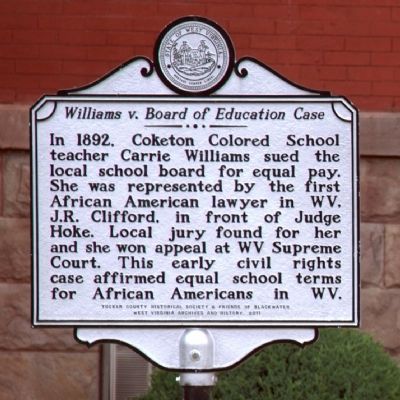 In 1892, Coketon Colored School teacher Carrie Williams sued the local school board for equal pay. She was represented by the first African American lawyer in WV, J.R. Clifford, in front of Judge Hoke. Local jury found for her and she won appeal at WV Supreme Court. This early civil rights case affirmed equal school terms for African Americans in WV.
 The violent waters of the Whirlpool Rapids flow into the Eddy Basin before entering the Whirlpool.
 The 35th mayor of Memphis, 1906-1910. Author of "The Chickasaw Nation". He shared a legal office on the 11th floor of the exchange building, overlooking Court Square, with his younger brother Walter Malone. Judge of the second circuit court of Shelby County. Walter was a writer and author of the famous poem "Opportunity".
 This property has been placed on the National Register of Historic Places by the United States Department of the Interior.
 Hasten Poe, a veteran of the War of 1812, moved from Virginia and built a log structure on this site in 1818. The area became known as Poe’s Cross Roads, later Daisy and in 1969 Soddy Daisy. The structure was used as a tavern and inn. On October 25, 1819, Hamilton County was formed from the southern section of Rhea County. The tavern served as Hamilton County’s first courthouse and county seat.
 At Bentonville, General William T. Sherman's Union Army, advancing from Fayetteville towards Goldsboro, met and battled the Confederate Army of Generla Joseph E. Johnston. General Robert E. Lee had directed the Confederates to make a stand in North Carolina to prevent Sherman from joining General U.S. Grant in front of Lee's Army at Petersburg, Virginia.
 This point was established in 1857 by an 800 member expedition starting at the southwest corner of Missouri and working north. The party included soldiers, teamsters, cooks, astronomers and surveyors. The expedition took nearly six months, being hampered by rough terrain, heavy timber and high water.
 In 1861, Germantown was divided between secessionists and unionists until the news of Fort Sumter and President Abraham Lincoln’s call for volunteers tilted the balance in favor of secession. Germantown women announced on April 26, “We…offer to the (Confederate) soldiers of Germantown all the assistance in our power with our needles, and promise also to aid in the care and sustenance of their families during their absence. And should the war approach our own homes, we will watch over the sick and wounded (through strangers) as our own brothers or fathers.” Local men and other county residents formed the 4th Tennessee Infantry, C.S.A., which trained briefly at Germantown and later fought in such important battles as Shiloh, Chickamauga, and Nashville.
 The City began in 1833 as the hamlet of Pea Ridge, was renamed Germantown in 1836 and incorporated in 1841. The City of Germantown now includes the site of historic Nashoba Plantation. Union troops occupied the town during the Civil War. Yellow Fever decimated the population in the 1870's. The City's name temporarily changed to Neshoba during World War I.
 This was the site of a Civil War earthwork redoubt built by the Union Army as part of a series of forts guarding the Memphis & Charleston Railroad. The fort is thought to have been built in June 1863 by the 49th Illinois Infantry Regiment and used by them until they were replaced by the 52nd Illinois in August 1863. The fort was abandoned and burned by the end of October 1863.
 This church, built by slaves in 1854, played a significant role in Madison County’s Civil War experiences. In April 1861, days after the firing on Fort Sumter, South Carolina, 104 local men formed a company called The Danes, later part of the 6th Tennessee Infantry (CSA). The community gathered here at the church to watch the new soldiers muster before they left for Camp Beauregard in nearby Jackson. At the ceremony, Emma Cobb presented a silk flag with the company’s name to Capt. John Ingram.
 On 15 May 1861, one hundred and forty six men swore allegiance to the South. This unit became known as Co. K, 6th Tenn. Inf. Reg., C.S.A. "The Denmark Danes".
 August 31, 1862
The 20th and 30th Illinois Infantry camped in the mulberry trees behind the Denmark Presbyterian Church. Denmark was the fairly large town and was a major shopping point for the armies.
August 31, 1862
The 20th and 30th Illinois Infantry camped in the mulberry trees behind the Denmark Presbyterian Church. Denmark was the fairly large town and was a major shopping point for the armies. April 6, 1862
Billy Caldwell, a redheaded fellow, was killed at Shiloh. He was the flag bearer for Denmark Danes. He died with the flag in his hand. The flag was shot to shreds and the staff that held it was hit twenty six times. The flag fell to the ground six times, but each time was secured by a member of the guard, and again waved on high. When the last of the guard fell, the tattered banner, red with the blood of the brave guard that lay dead and dying around it, was seized by Private Posey of Company A. Billy had made a short speech at the Denmark Church in which he said he would carry the flag to Washington and shake it in the face of Abe Lincoln, or something of that kind.
April 6, 1862
Billy Caldwell, a redheaded fellow, was killed at Shiloh. He was the flag bearer for Denmark Danes. He died with the flag in his hand. The flag was shot to shreds and the staff that held it was hit twenty six times. The flag fell to the ground six times, but each time was secured by a member of the guard, and again waved on high. When the last of the guard fell, the tattered banner, red with the blood of the brave guard that lay dead and dying around it, was seized by Private Posey of Company A. Billy had made a short speech at the Denmark Church in which he said he would carry the flag to Washington and shake it in the face of Abe Lincoln, or something of that kind. In August 1862, Confederate Gen. Sterling Price ordered Gen. Frank C. Armstrong to conduct a raid with 2,000-man cavalry brigade to determine the strength and location of Union forces in West Tennessee. The raiders left Guntown, Mississippi, on August 22 and arrived in Holly Springs four days later, where Col. William H. Jackson’s mounted regiments joined them. The combined force of 3,000 men crossed into Tennessee on August 29. Riding northeast, they encountered Union Col .Mortimer Leggett’s brigade near Bolivar and engaged it in a fight that lasted most of the day. Both commanders claimed victory, but the Federals held the field. Bypassing the fortifications at Bolivar, Armstrong’s troopers destroyed railroad and telegraph facilities between Toone and Medon. Several Federal detachments gathered at Medon Station, constructed a cotton-bale barricade, and held off a Confederate attack.


