Maryland, Cecil County, Perryville
![]() After burning much of Havre de Grace May 3, 1813, British raiders crossed the Susquehanna to Cecil County. At Principio Iron Works they captured a five-gun battery and destroyed the foundry complex and the bridge across Principio Creek. More than 40 finished cannon were also lost to the American war effort that day.
After burning much of Havre de Grace May 3, 1813, British raiders crossed the Susquehanna to Cecil County. At Principio Iron Works they captured a five-gun battery and destroyed the foundry complex and the bridge across Principio Creek. More than 40 finished cannon were also lost to the American war effort that day.
Strategic Target
Principio began operation in 1725 and by 1727 had Maryland's first blast furnace and refinery forge. By 1796 it supplied cannon for the U.S. Navy and privateers. A newspaper reported: "It is not improbable that this Furnace is the object of the enemy's approach to (the) neighborhood."
"The Cecil or Principio Foundery...was one of the most valuable Works of the Kind in America, the Destruction of it...will I trust prove of much national Importance."
British Rear Adm. George Cockburn to Adm. John B. Warren, May 3, 1813
(Industry & Commerce • War of 1812) Includes location, directions, 3 photos, GPS coordinates, map.
 After burning much of Havre de Grace May 3, 1813, British raiders crossed the Susquehanna to Cecil County. At Principio Iron Works they captured a five-gun battery and destroyed the foundry complex and the bridge across Principio Creek. More than 40 finished cannon were also lost to the American war effort that day.
 Strategic Target
Principio began operation in 1725 and by 1727 had Maryland's first blast furnace and refinery forge. By 1796 it supplied cannon for the U.S. Navy and privateers. A newspaper reported: "It is not improbable that this Furnace is the object of the enemy's approach to (the) neighborhood."
"The Cecil or Principio Foundery...was one of the most valuable Works of the Kind in America, the Destruction of it...will I trust prove of much national Importance."
British Rear Adm. George Cockburn to Adm. John B. Warren, May 3, 1813
(Industry & Commerce • War of 1812) Includes location, directions, 3 photos, GPS coordinates, map.
 This Kentucky Poet Laureate was born and lived most of his life in W-Hollow, near Greenup. An educator and prolific writer, Stuart authored books, short stories, and poems which portray Appalachian Ky. He received Guggenheim fellowship, 1937; nominated for Pulitzer Prize in Poetry, 1977. Works include The Thread That Runs So True and Man with a Bull-Tongue Plow.
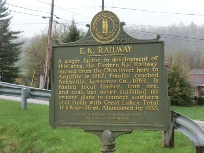 A major factor in development of this area, the Eastern Ky. Railway opened from the Ohio River here to Argillite in 1867; finally reached Webbville, Lawrence Co., 1889. It hauled local timber, iron ore, and coal, but never fulfilled its owners' plans to connect southern coal fields with Great Lakes. Total trackage; 36 mi. Abandoned by 1933. Presented by Eastern Ky. Railway Historical Society and Greenup County Fiscal Court.
 Nearby a monument marks the site of the second church at Kecoughtan (later Hampton), built in 1624 for Elizabeth City Parish, established 1610 and now the oldest Protestant parish in continuous existence in America. This building was replaced before 1667 by a third parish church west of the town and was pulled down in 1698.
 Hampton Institute began the Hampton Indian Program to “christianize and civilize” American Indians. The first students arrived at the Institute near midnight on 13 April 1878. They had been incarcerated at Fort Marion in St. Augustine, Florida, in an attempt by the U.S. government to control their kinsmen. Later, government officials recruited males and females from 65 tribal groups from the Midwest and Southwest. Approximately 1,388 students participated before the program ended in 1923. Thirty-eight students from the program are interred in the integrated campus cemetery. The Hampton Indian Program became the model for the Carlisle Indian Industrial School in Pennsylvania.
 The East Wetzel Trail is built on the bed of the Baltimore & Ohio Railroad. The line connecting Cumberland, MD to Wheeling, VA (later WV) was completed on Christmas Eve 1852. This route, over the Alleghenies, was the most challenging mountain terrain ever attempted and required construction of eleven tunnels, five of which were located in this area (Glover Gap, Sole, Martin, Marshall and Board Tree). Board Tree was the most notable and significant in B&O history. Burton was an important passenger and freight stop and the largest Civil War marshaling yard in the western section of the B&O. Hundred, settled by Henry and Hannah Church, was a flagstop and became a railroad tourist attraction as the home of the "oldest couple in the states". Littleton, along with its oil and gas industry, gained national importance during the Civil War when Union forces opened an iron ore mine and shipped the ore east to make ammunition. Undoubtedly, the construction of the B&O enabled these towns to thrive during the heyday of the railroad.
 Site of Baldwin blockhouse, 1770-1775. Brice and Nathan Worley settled here in 1766. Nathan was killed by Indians in 1777. Laid out as a town in 1829 and lots sold through a lottery. Town is named for David Black, early settler.
 Warrior Branch of the Great Catawba Indian War Path. Here are located the three crossings of Dunkard Creek by Mason and Dixon. Here the Chief of the Six Nations Indians declared that he "would not proceed one step further." Here hostile Shawnees and Delaware Indians ordered them to stop. The Mason-Dixon survey ended on the next high ridge on Brown's Hill.
 Made famous as line between free and slave states before War Between the States. The survey establishing Maryland-Pennsylvania boundary began, 1763; halted by Indian wars, 1767; continued to southwest corner, 1782; marked, 1784.
 John Statler built a fort here in 1770. In its vicinity a number of settlers were Indian victims in 1777 and 18 white men lost their lives the next year. Later Statler himself and companions were massacred.
 The Battle of Brandywine was the largest and longest battle of the American Revolution
 To the west, on the grounds of Hampton University, stands the Emancipation Oak. Under its sheltering limbs, protected and encouraged by the occupying Union army and prominent local church leaders, Mary Smith Kelsey Peake (1823- 22 Feb. 1862) taught her fellow African Americans to read and write as the Civil War began. She founded the first black school in Hampton at Brown Cottage in September 1861; it was a forerunner of Hampton University. In 1863, following the issuance of the Emancipation Proclamation by President Abraham Lincoln, Hampton residents gathered beneath the oak to hear the text read aloud.
 The Battle of Brandywine involved 28,000 soldiers in combat and was the largest and longest battle of the American Revolution
 On July 6, 1864, Confederate cavalryman cross the Potomac River into Maryland as part of a 12,000 man force under Gen. Jubal A. Early, who planned to attack lightly defended Washington, DC., and draw off part of the Union army menacing Richmond and Petersburg. union Gen. Lew Wallace's force, however, delayed Early at the Monocacy River on July 9. Early Ordered Gen. Bradley T. Johnson's cavalry brigade to cut off Baltimore and Washington from the north, then to free 14,000 Confederate prisoners at Point Lookout, Maryland.
  Near here Captain John Ratcliffe built Fort Algernourne, 1609. In 1614, it was a stockade containing fifty people and seven cannon. In 1632, the fort was rebuilt. It was discontinued after 1667. In 1727, a new fort, Fort George, was ordered built here. This fort was destroyed by a hurricane in 1749.
 In 1873, Bennet Cooper (1797-1886) gave one-quarter of an acre of land for a family burying ground. His first wife, Lydia, was buried there along with several other family members. The cemetery is located on a ridge behind the Cooper Homeplace which was built by Hair Conrad, a Cherokee Indian, who lead the Trail of Tears. In 1930, Pearson Blythe Mayfield purchased the property. Mrs. David H. Neil obtained the land known as Blythewood Farms from her father and preserved Cooper Cemetery.
 The viral disease of smallpox - widespread in 19th century Ontario - flared up in a severe epidemic in Hungerford Township in 1884. The outbreak claimed at least 45 lives in 202 reported cases and disrupted economic activity and family life for many more. Local efforts by municipal authorities and private physicians were initially unable to halt the disease, and its wider spread throughout the province seemed likely. The newly established Provincial Board of Health and its hired officers swiftly undertook fumigation, enforced isolation and mass vaccination. The disease was contained, proving the value of public health measures applied consistently under coordinated direction. The Hungerford experience demonstrated the importance of quality vaccine, reliable supplies and skilled vaccinators. The Board's actions in 1884 transformed Ontario's approach to disease control when over 400 local boards of health were formed to assist in the delivery of essential medical services. As a result, Ontario earned an international reputation as an aggressive and innovative public health advocate during the mid-1880s.
 The defeated Indian League of the Iroquois received a large reservation across Erie County, at the end of the American Revolution. William Street forms part of the north boundary of this Buffalo Creek Indian Reservation. The final sale treaty, signed in 1842, ended the 65 year Indian occupation of the reservation in southern Cheektowaga. Erected by Town Board, Town of Cheektowaga, 1964.


