Texas, Tom Green County, San Angelo
![]()
A dedicated member of the Methodist Church and a gifted teacher, Mrs. Massie was a humanitarian who worked to further education throughout her life.
The former Mary Lee Payne, Mrs. Massie was born in Weimar [Texas], one of four children. She grew up under the stress of pioneer life and worked, in various towns, as a teacher, postmaster and saleslady. Although her education was interrupted when her wardrobe was lost in fording a river, she later attended Buffalo Gap College. In 1899 she married Robert Massie.
Massie, born in Scotland, came to this country as a youth. From a sheep herder's job, he advanced to a leading place in the sheep and wool industry, making a fortune in this and other varied businesses.
Mary and Robert Massie reared an adopted daughter, 3 of their young nephews, and a niece. Mrs. Massie resumed public and Sunday school teaching, taking a special interest in the Junior Department of the Methodist Church in this city.
Following their deaths in 1931, Mrs. Massie's will gave a large portion of the estate to the benefit of youth. The Massie Memorial Foundation has, since 1932, provided over 2,000 student scholarships.
Until 1960 the Massie Home stood at this site.
————————————
Massie Club House
dedicated to the memory of Robert and Mary Massie and presented by the Massie Educational Foundation to the City Federation of Women's Clubs of San Angelo to be used for the spiritual, intellectual, physical, and social development of San Angelo and surrounding territory.
(Charity & Public Work • Education • Industry & Commerce • Man-Made Features) Includes location, directions, 3 photos, GPS coordinates, map.


 Opened in April, 1855, the five-story, 240 room De Soto House was “the largest and most luxurious hotel in the West.” Abraham Lincoln spoke from its balcony in 1856 and Stephen A. Douglas in 1858. Ulysses S. Grant maintained his 1868 presidential campaign headquarters here. By 1880 Galena's prosperity had faded and the hotel's two upper stories were removed.
 Home and ranch of Don Manuel Gonzalez was one-half mile east. Consisted of 1600 arpents conceded by Spanish Governor, Jose Mascot, Dec. 22, 1817.
 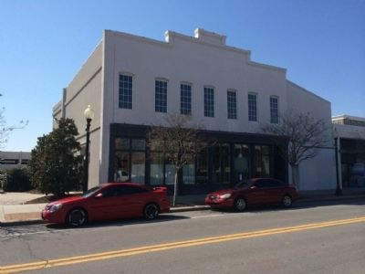 This building was erected in 1896 and rented to numerous businesses until the 1950s. One of the most significant tenants in the early 1900s was Samuel Charles, one of Pensacola's most prominent black businessmen, whose shoe repair shop became Pensacola's largest shoe repair and sales store at that time. In the 1920s the building was occupied by Birgar Testman's ship chandlery. Since the early 1950s the building has been owned and occupied by Trader Jon's, a favorite haunt of U.S. Navy and other military personnel. The tavern has gained international fame for its unusual and extensive display of military memorabilia which surrounds the clientele.
 This is the site of John the Baptist Church, one of the oldest Baptist Churches in Pensacola. In 1846 the First Baptist Colored Church of Pensacola, known today as Historic John the Baptist Church, was organized in the Seville Square community. The church served black and white Baptists until the Civil War (1861-1865). Retreating and invading armies threatened to burn Pensacola, causing all residents except 72 white and 10 black people to relocate to Alabama. During the war, African-American Baptists kept this, the only Protestant church in Pensacola open. After the war, a dispute arose between black and white Baptists regarding the church property. In 1866, black Baptists wrote a letter to the Freedmen’s Bureau explaining that the black Baptists purchased the property and “upon it erected a place of worship.” The letter also explained that the property had always been in use of the congregation and that since the war others claimed control of it. In 1870, the black congregations relocated, under the leadership of Rev. Robert Ahrens (c. 1833-1925), to this site in the Hawkshaw community. The Seville Square church housed a Freedmen’s Bureau school and the church at Hawkshaw housed a school for children and adults.
 The Sisters of Mercy began the Catholic Church's work for blacks in Pensacola when they opened St. Joseph Colored and Creole School on September 8, 1879. St. Joseph Catholic Church, built in 1891, was the 1st African-American parish in the Diocese of Mobile. The first Church was a two-story frame building. The present Gothic revival style church, built in 1894, cared for the needs of African-Americans, Creoles, Germans, Italians, and Irish immigrants. In the 1920's, Fr. Charles Hartkoff, the church's second pastor, built and opened St. Joseph orphanage which took in homeless African-American boys. In 1939, Fr. Joseph J. Raleigh closed and reopened one school operated by the Sisters of Charity of Convent Station, New Jersey. Two years later, St. Joseph High School opened, the only Catholic African-American high school in the state of Florida at the time. At its height, St. Joseph's operated "Maryall Negro Missions" which included four chapels: Mary Immaculate, Our Lady of Victory, Our Lady of Fatima and Our Lady of Africa. Other ministries included Our Lady of Fatima Mission School and Our Lady of Angels Maternity Hospital for African-American women located beside the Church's grammar and high school.
 On this site, Pensacola Junior College (PJC) opened its doors on September 13, 1948. It was the first public junior college created by the Florida Legislature under the Minimum Foundation Program Act of 1947, signed into law by Governor Millard F. Caldwell. The Escambia County School Board received authority to establish the college. District staff Jesse Barfield and Margaret Andrus helped James L. McCord, principal of Pensacola High School, prepare the initial proposal and continued as faculty. McCord became the first director of PJC. The Aiken Boarding House provided classrooms for the first 136 students. James H. Allen, president of Florida Pulp and Paper Company, contributed the first two year’s rent for the facility. In June 1953, the College moved one block south to the old Pensacola High School. On May 13, 1955, Governor LeRoy Collins signed a bill appropriating $1,243,000 to the college, which resulted in the 1956 purchase of property on 9th Avenue, now the college’s main campus. Pensacola’s Booker T. Washington Junior College was established as Florida’s first black junior college in 1949, and at the height of the Civil Rights Movement, merged with PJC in 1965.
 On March 9, 1781, Spanish General Bernardo de Galvez, with a fleet of some 30 ships, arrived opposite Pensacola Bay and within a day took Santa Rosa Island. On March 18, Galvez, in his ship Galveztown, sailed under the cannon of the Royal Navy Redoubt into the harbor, thereby inspiring the rest of the fleet to follow him. The British Army abandoned the town of Pensacola to take position on the fortified hills north of the town. After more than a month of siege and skirmishing, a shell from a Spanish howitzer destroyed most of the Queen's Redoubt and resulted in General John Campbell's capitulation and surrender of British West Florida. Although Spain was not a formal ally of the United States, her victory at Pensacola made a significant contribution to the success of the American Revolution.
 Asa Randall 1788- 1858, Mary W. Randall 1787-1847, Asa Randall Jr. 1823-1847, Tim Bachelder 1788-1834, George T. Parker 1824-1904, Erminda Parker 1825-1906, Marion W. Parker 1850-1850, Miron W. Morton 1832-1835.
 Founded 1830 First known as Halstead Cemetery for Charles Halstead. Cemetery Association formed 1874 Chairman Thomas Simmons and Secretary Levi Brookins
 So~named because under British, each purchaser of lots in the Old City (South of here) was given a plot with the corresponding number (North of here) on Conway Street for garden purposes. Lots were 80' x 278'. Section included present Garden Street between Spring Street (Washerwoman's Bayou) and Seventh Avenue (Cadet Bayou).
 Site of Fort San Bernardo. Built by Don Bernardo de Galvez, Governor of Spanish Louisiana. From this Fort the Spanish bombarded the English-held Fort George; April 27, 1781 and Fort George surrendered May 9, 1781. 15,000 soldiers occupied Fort San Bernardo; 1,500-2,000 soldiers were stationed at Fort George. As a result of this battle all of Florida from the Apalachicola River to the Mississippi River passed from Britain to Spain.


