Alabama, Henry County, near Shorterville
![]()
Side 1
“The Mansion” was built in the 1830's on this site by Colonel James Bennett and his wife, Harriet M. Grace. Tradition maintains that it was the only three story antebellum home in the Chattahoochee Valley. The top floor was a ballroom. Six columns spanned the façade which included a winding staircase. “The Mansion” could be seen from the Chattahoochee River and was know by riverboat travelers as "The Showplace of the South."
James Bennett came to Alabama in 1817 with his father, Luke Bennett. They first settled on a ridge between what is now Clayton and Louisville along with James Arthur, Pious Chambers, and others. (Continued on other side) Side 2
(Continued from other side) “The Mansion” later burned to the ground leaving only the kitchen standing. Its construction of 10"x10" beams set on concrete blocks made of sand and pebbles from the property. Cut nails and large steel spikes were used throughout the building.
The cemetery here holds the graves of Colonel James Bennett; Bartlett Smith Bennett, infant son; James W. Bennett, CSA; John B. Bennett, CSA; the Bennett slaves; and the construction overseer from New York, Mr. Williams, who died of pneumonia before "The Mansion" was completed. Harriet Grace Bennett rests in an unmarked grave in the Shorterville Baptist Church cemetery near her son Thomas.
(Notable Buildings) Includes location, directions, 4 photos, GPS coordinates, map.
 Site of the 1831 Irwin homeplace where over 50,000 acres of land was owned by Major General William Irwin (1794-1850). He was an Indian fighter, farmer, politician, statesman and considered one of the nation’s richest and most influential men. A portion of his land was awarded for services rendered during the Indian wars. Irwinton (Eufaula) was his namesake. He was a major force in the disposition of the last Indian lands. He drowned in the Chattahoochee River and was buried near his homesite.
 This early settlers' church was constituted as a member of the Choctawhatchee Association District here on the Eufaula-Ozark Wagon Train Road, April 23, 1860. First Presbytery was M.W. Helms and J.J. Dickerson, Deacon William Hasten and Clerk D.R. Clanton. About 50 members composed the first membership. Other elders were: Aaron Helms, S.S. Pellum, L.H. Stuckey, P.L. Thomas, Henry Pellum, Albert Lee Ray, W.I. Kelley, Alto Walker, Tom McGowin, R.K. Blaskshear, and S.J.B. Dallas.
 Liberty United Methodist Church
 Old Center Methodist Church
 The Treaty of Fort Jackson on August 9, 1814 by Major General Andrew Jackson on behalf of the President of the United States of America and the Chiefs, Deputies and Warriors of the Creek Indian Nation, established a boundary line between the Mississippi Territory and the Creek Nation. The line ran across present-day Henry County from the mouth of Hardridge Creek to south of Chester Chapel Church. The Creek Treaty of 1832 ceded this reservation line allowing Henry County's northeast boundary to be extended from this line north to White Oak Creek. This is the only instance when Henry County gained land.
 The Treaty of Fort Jackson on August 9, 1814 by Major General Andrew Jackson on behalf of the President of the United States of America and the Chiefs, Deputies and Warriors of the Creek Indian Nation, established a boundary line between the Mississippi Territory and the Creek Nation. The line ran across present-day Henry County from the mouth of Hardridge Creek to south of Chester Chapel Church. The Creek Treaty of 1832 ceded this reservation line allowing Henry County's northeast boundary to be extended from this line north to White Oak Creek. This is the only instance when Henry County gained land.
 To the glory of God
 First settler crossings were made here prior to 1817 on a log ferry operated by Robert Irwin. First bridge built by Prescott and Bemis and destroyed by flood of 1855. Second wooden covered bridge was completed in 1869 by ex-slave Horace King. Third was the Henry-Clay cantilever bridge opened in 1925. Fourth is the present McKemie Bridge opened in 1973. This river was the number one highway for local prehistorical man long before Christ.
 The frontier village of Franklin was established here by Colonel Robert Irwin in 1814 on the site of the Indian town of Cheeska Talofa. It was the first colonial village in east Alabama. Fort Gaines, Georgia, was constructed in 1816 to protect the early settlers in this former Creek Indian Nation, West. Twenty-one blocks were laid off for this promising river port of Abbeville. This prospective early city never recovered from the destructive flood of 1888.
 A barrage of arms fire was leveled against the Cheyenne and Arapaho. Amid the wild confusion, soldiers noticed people at the village “... going slowly away in a sort of listless, and dazed, or confused manner ...” Throughout the morning and into the afternoon, Volunteers pursued the Indians up Sand Creek and across adjacent plains and bluffs. The scene became chaotic as troops advanced up both sides of the creek. A member of the 3rd Colorado remembered, “After a short dash we halted and dismounted ... events succeeded each other so rapidly now, that no one could look about much to see what the other companies did.”
 Majestic Mount Blanca that stands bgefore you is surrounded by history and legend from the first people who inhabited this valley. Many Native American groups believe that this valley is the source of life where humans and spirit enter and leave this world.
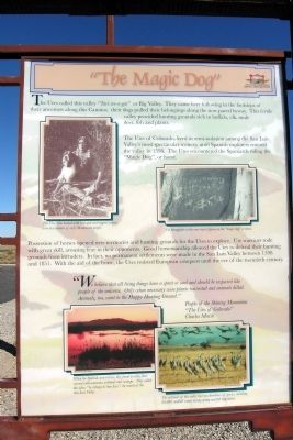 The Utes called this valley “Tavi-we-a-gat” or Big Valley. They came here following in the footsteps of their ancestors along this Camino; their dogs pulled their belongings along the now paved byway. This fertile valley provided hunting grounds rich in buffalo, elk, mule deer, fish and plants.
 ¡Bienvenidos! Caminantes!
 You have entered the land of the Rio Bravo del Norte, the northernmost outpost of sixteenth century Spain. To the Spanish people, the San Luis Valley was a wild and unexploited place known only to the Native people. Amidst the beauty and towering peaks of the valley, the area became the center of conflict and wars born of a clash of cultures.
 In February 1874 a large Chinese work force entered this woodland setting to begin construction of San Leandro Reservoir. Later renamed Lake Chabot after its French-Canadian originator Anthony Chabot, the dam was built using techniques Chabot learned and invented in the gold-fields of California.
 The giant drums in front of you were designed and built in 1888 as part of the filtration plant that processed water from Lake Chabot. Water was forced through these sand filters to remove impurities. Named after the engineer who designed them, the Hyatt Filters are preserved here as part of a Historic Engineering Landmark.


