Idaho, Butte County, near Arco
![]() Big Southern Butte -- A Waypoint for Thousands of Years
“Just passing through, ma’ma”
The harsh conditions on the plain discouraged most long-term settlement, but Big Southern Butte was a clear waypoint. In the 1800s, travelers headed toward Fort Boise would often take the Goodale Cutoff, an Oregon Trail shortcut. They would leave Fort Hall on the Snake River (about 40 mi [64 km] southeast), and head toward the Butte’s sharp silhouette, passing to its north. An 1878 stage line from Blackfoot to the copper mines near Mackay and Challis followed a similar path. Later, the Oregon Short Line Railroad followed the same route.
Big Southern Butte -- A Waypoint for Thousands of Years
“Just passing through, ma’ma”
The harsh conditions on the plain discouraged most long-term settlement, but Big Southern Butte was a clear waypoint. In the 1800s, travelers headed toward Fort Boise would often take the Goodale Cutoff, an Oregon Trail shortcut. They would leave Fort Hall on the Snake River (about 40 mi [64 km] southeast), and head toward the Butte’s sharp silhouette, passing to its north. An 1878 stage line from Blackfoot to the copper mines near Mackay and Challis followed a similar path. Later, the Oregon Short Line Railroad followed the same route.
Travelers on the Oregon Trail, and later stagecoach lines and the Oregon Short Line Railroad, relied on fresh water from springs at the base of Big Southern Butte.
“. . . travelers on the Challis Stage Road find the Big Butte Station a pleasant place to stop . . .”
Idaho News (Blackfoot, Idaho), June 25, 1887
A Source of Obsidian
Big Southern Butte was frequently visited by Native American groups. It was a source for obsidian, a volcanic glass used for arrow and spear tips. Archaeologists have found the Butte’s unique obsidian at sites throughout Idaho, Montana, Utah and as far away as California’s Joshua Tree National Monument. Today, the Butte and surrounding landscape remain spiritually impartant to the descendants of these groups, the Shoshone-Bannack Tribes.
Earliest People
People have lived on these lands for more than 10,000 years. Native American hunting and gathering parties valued the plain’s resources as shown by archaeological evidence -- stone tools, ancient campsites and pictographs.
Native Americans, specifically Shoshone-Bannock Tribes, contine to value the natural and cultural resources of these lands. The Idaho National Laboratory Site lies within the aboriginal lands of the Shoshone and Bannock people. Tribal members work with the U.S. Department of Energy to protect the significant resources found here.
Ancient Lake Terreton
Throughout most of the Pleistocene epoch---about 1.8 million to 10,000 years before present—a large shallow inland lake and surrounding streams and wetlands provided abundant resources for the plain’s nomadic people. Mammoths, camels and other ice Age fauna were abundant.
The lake and Ice Age mammals disappeared when the climate changed about 10,000 years ago. Mud Lake is the modern remnant of the ancient lake.
(Inscription under the photos in the lower left)
The pictograph panel (above) shows figure drawings that are unique to this area. Also is a photo of 1900s Shoshone, courtesy of the Shoshone-Bannock Tribes.
(Inscription under the photo in the lower center)
Historic artifacts reflect the broken dreams of those who attempted to settle here.
(Inscription under the photo in the upper right)
The Oregon Short Line freight train at the Arco depot in 1912, 11 years after the line was completed.
(Settlements & Settlers) Includes location, directions, 1 photo, GPS coordinates, map.
 Big Southern Butte -- A Waypoint for Thousands of Years
“Just passing through, ma’ma”
The harsh conditions on the plain discouraged most long-term settlement, but Big Southern Butte was a clear waypoint. In the 1800s, travelers headed toward Fort Boise would often take the Goodale Cutoff, an Oregon Trail shortcut. They would leave Fort Hall on the Snake River (about 40 mi [64 km] southeast), and head toward the Butte’s sharp silhouette, passing to its north. An 1878 stage line from Blackfoot to the copper mines near Mackay and Challis followed a similar path. Later, the Oregon Short Line Railroad followed the same route.
Big Southern Butte -- A Waypoint for Thousands of Years
“Just passing through, ma’ma”
The harsh conditions on the plain discouraged most long-term settlement, but Big Southern Butte was a clear waypoint. In the 1800s, travelers headed toward Fort Boise would often take the Goodale Cutoff, an Oregon Trail shortcut. They would leave Fort Hall on the Snake River (about 40 mi [64 km] southeast), and head toward the Butte’s sharp silhouette, passing to its north. An 1878 stage line from Blackfoot to the copper mines near Mackay and Challis followed a similar path. Later, the Oregon Short Line Railroad followed the same route.Travelers on the Oregon Trail, and later stagecoach lines and the Oregon Short Line Railroad, relied on fresh water from springs at the base of Big Southern Butte.
“. . . travelers on the Challis Stage Road find the Big Butte Station a pleasant place to stop . . .”
Idaho News (Blackfoot, Idaho), June 25, 1887
A Source of Obsidian
Big Southern Butte was frequently visited by Native American groups. It was a source for obsidian, a volcanic glass used for arrow and spear tips. Archaeologists have found the Butte’s unique obsidian at sites throughout Idaho, Montana, Utah and as far away as California’s Joshua Tree National Monument. Today, the Butte and surrounding landscape remain spiritually impartant to the descendants of these groups, the Shoshone-Bannack Tribes.
Earliest People
People have lived on these lands for more than 10,000 years. Native American hunting and gathering parties valued the plain’s resources as shown by archaeological evidence -- stone tools, ancient campsites and pictographs.
Native Americans, specifically Shoshone-Bannock Tribes, contine to value the natural and cultural resources of these lands. The Idaho National Laboratory Site lies within the aboriginal lands of the Shoshone and Bannock people. Tribal members work with the U.S. Department of Energy to protect the significant resources found here.
Ancient Lake Terreton
Throughout most of the Pleistocene epoch---about 1.8 million to 10,000 years before present—a large shallow inland lake and surrounding streams and wetlands provided abundant resources for the plain’s nomadic people. Mammoths, camels and other ice Age fauna were abundant.
The lake and Ice Age mammals disappeared when the climate changed about 10,000 years ago. Mud Lake is the modern remnant of the ancient lake.
(Inscription under the photos in the lower left)
The pictograph panel (above) shows figure drawings that are unique to this area. Also is a photo of 1900s Shoshone, courtesy of the Shoshone-Bannock Tribes.
(Inscription under the photo in the lower center)
Historic artifacts reflect the broken dreams of those who attempted to settle here.
(Inscription under the photo in the upper right)
The Oregon Short Line freight train at the Arco depot in 1912, 11 years after the line was completed.
(Settlements & Settlers) Includes location, directions, 1 photo, GPS coordinates, map.
 A Traditional American Barn
 This barn was built in the late 1850’s by Thomas and Mary Coyle. It originally stood in the old Trinity Center and, for a time, was used to shelter guest’s horses at the Holland House Hotel on the road to Oregon. In 1859, when flooding of old Trinity Center was imminent with the building of Trinity Dam, the owner of the barn, William Foster Jr., donated it to the state.
 The Southside Ruins marker consists of 9 plaques which depict the history of these former Shasta business buildings and the history of the town of Shasta itself. The 9 plaques are in groups of three, four and two and are presented below from east to west. Click on the photograph of each plaque to enlarge the captioned images.
 Idaho’s earliest toll bridge spanned Snake River at this rocky site in 1865, replacing Eagle Rock Ferry, 9 miles upstream.
 On June 20, 1863, Bill Hickman started a ferry 9 miles up Snake River for thousands of gold hunters headed for mines that now are in Montana.
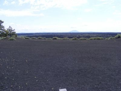 From this vantage point, you gaze across 25 miles of lava to Big Southern Butte. Early pioneers, following Goodale’s Cutoff from the Oregon Trail, used this land mark to navigate around the rugged lavas of the Snake River Plain. As a traveler today, you may have trouble seeing Big Southern Butte clearly due to the presence of air pollution.
 The Strangest 75 square miles on the North American continent


 In 1713 Charles Calvert, third Lord Baltimore gave to his wife, Margaret 10,000 acres known as My Lady;s Manor. In 1731, Thomas Brerewood was engaged to manage the land. During the Revolution the property was confiscated by Maryland and in 1782 sold at auction to veterans and tenants. Descendants of original owners continue to live on the manor to this day.


 DEC. 19th, 1813. Site of log cabin arsenal used by settlers, who with the aid of the Tuscaroras halted the British from burning areas eastward.
 In 1858, nearly 800 free Blacks left the oppressive racial conditions of San Francisco for a new life on Vancouver Island. Governor James Douglas had invited them here as promising settlers. Though still faced with intense discrimination, these pioneers enriched the political, religious and economic life of the colony. For example, Mifflin Gibbs became a prominent politician; Charles and Nancy Alexander initiated the Shady Creek Methodist Church; John Deas established a salmon cannery; and the group formed one of the earliest colonial militia units, the Victoria Pioneer Rifle Corps.
 Constructed of river rocks hauled by horse and cart from the nearby Little Patuxent River, the stone building on Baltimore Street has been a landmark in the town of Savage since 1922. Its distinguishing features include large windows with stone arches, a massive chimney and a state roof. The style is a blend of Romanesque Revival architecture with Queen Anne and Beaux Arts elements.
 Watering trough marks location of first Grimes Golden Apple tree, discovered by owner of land, Thomas Grimes, in 1802. Memorial Trough sponsored by the Franklin Country Women's Club in 1922.


