Quantcast
Channel: The Historical Marker Database - New Entries
Viewing all 103834 articles
Browse latest View live

Have honor for Nathaniel Rochester

$
0
0
New York, Monroe County, Rochester

Have honor for Nathaniel Rochester
after whom our city was named.
Born in Virginia 21 February 1752
Colonel in the American Revolution
Patriot Pioneer Founder
He typified in his honorable public service and private enterprise the best pioneer traditions of the Genesee Country.
He shaped our young village, he was the earliest promoter of our prosperity, parting with his possessions to procure a virile population. In the wilderness he had a vision of a city.
As a man, his life was of constant integrity and primitive simplicity, winning the affection of a grateful community. He had courage, energy and faith. He gave our city more than a name - the heritage of his inspiring personality.
On this site stood his home built in 1824 where he died 17 May 1831.

(Colonial Era • Settlements & Settlers • War, US Revolutionary) Includes location, directions, 3 photos, GPS coordinates, map.

Trophy Cannon presented to Monroe County by Hon. O.F. Williams.

$
0
0
New York, Monroe County, Rochester
.
Taken from the Spanish flag-ship Reina Christina at Manila Bay, May 1, 1898.

Dedicated November 28, 1902 by L. Bordman Smith Command No. 53, Spanish War Veterans, Memorial to Monroe County Comrades who sacrificed their lives on the altar of their country.

On Fames eternal camping ground
their silent tents are spread,
And Glory guards with solemn round
the bivouac of the dead.

(War, Spanish-American) Includes location, directions, 4 photos, GPS coordinates, map.

Site of First House

$
0
0
New York, Niagara County, Niagara Falls
Built by Judge Porter in 1808. Many notable visitors and friendly Indians were received within its walls.

(Settlements & Settlers • War of 1812) Includes location, directions, 3 photos, GPS coordinates, map.

Dunseverick Castle

$
0
0
United Kingdom, Northern Ireland, County Antrim, Dunseverick


Dunseverick Castle and its rocky peninsula were given to the National Trust in 1962 by farmer Jack McCurdy.

The term Dun (fort) indicates a royal site. This was the fort of Sobhairce. It may have been a royal stronghold in the Iron Age (around 500 B.C.) and traditionally was one of the great duns of Ireland.

St. Patrick reputedly visited Dunseverick in the 5th Century. The extensive earthworks on the headland may be the remains of the royal fort from which the Antrim kingdom of Dalriada was ruled in the Early Christian period. It was attacked and captured by Vikings in 871 and later destroyed by them in 926.

The ruined 16th century stone tower remains from the period of struggles for supremacy between the main families - the MacDonnells, O'Neills, O'Cahans and MacQuillans.

———————

The Eider, a large sea duck, inhabits the bays along this coast all the year round. The male is black and white, the female brown. In summer, the male moults to a similar colour to the female. The female rears her young alone on nearby islands and below isolated headlands. She lines her nest warmly with feathers plucked from her own breast. This is the well known Eider-down.

From spring through to autumn, the coarse grasslands of the cliff tops and slopes may be sprinkled with mainly cream canopies of a range of flower species belonging to the family Umbelliferae. The umbel is the name for the clustered arrangement of the flowers Alexanders in April (favouring road verges), Pignut in May, Hogweed in June, Wild Carrot in July, Angelica in August and Yarrow throughout summer to autumn, some remaining in bloom into winter. These flowers are popular with insects, from small flies to orange soldier beetles.

———————

The Causeway Coast Path is managed by the National Trust in partnership with Moyle District Council, Coleraine Borough Council and through the co-operation of local landowners and the Department of Agriculture for Northern Ireland. The Giant's Causeway is owned and managed by the National Trust. The Visitor Centre and car parks are owned and managed by Moyle District Council. THIS PROJECT IS PART FINANCED BY THE EUROPEAN COMMUNITY European Regional Development Fund and the Department of the Environment for Northern Ireland.

(Environment • Forts, Castles • Man-Made Features • Settlements & Settlers) Includes location, directions, 5 photos, GPS coordinates, map.

Solid Friendships

$
0
0
Minnesota, Renville County, Morton

Made of solid granite, the “Friendly Indian Monument” was dedicated in 1899 in honor of six Dakota Indians who befriended and protected government employees, immigrant settlers, missionaries, or aided soldiers during the United States – Dakota Conflict of 1862, most often at the risk of their own lives.

Ana'wang ma'ni
Galloping Walks
Simon Ana'wang ma' ni
Ana'wang ma'ni assisted a woman and child to safety during the Conflict. He also served as one of General Henry Sibley's scouts during the years after the United States - Dakota Conflict of 1862.

Maqhkahto Heiya win
She is a Strong Determined Woman
Mary Crooks
Mahkahto Heiya win assisted in the protection of many captives.

Paul Ma'zakute'ma'ni
Shoots as He Walks
Little Paul
Ma'zakute'ma'ni spoke against the Conflict at Dakota councils and advocated the release of the captives held by Chief Little Crow. After the Conflict he served as an army scout for Sibley. Before the Conflict he rescued Miss Gardner from White Spider's camp along the James River after the Spirit Lake Massacre of 1857.

Snasna’win
Tinkling
Maggie Brass
Snasna’win purchased 14 year old Mary Schwandt for the price of a pony from a Dakota warrior and adopted her as her own during the United States - Dakota Conflict of 1862 to protect her from harm.

Tonwanetaton
Faces the Village
Lorenzo Lawrence
Tonwanetaton led a number of settlers to the safety of Fort Ridgely during the United States-Dakota Conflict of 1862. During the Battle of Wood Lake and after the Conflict, he served as a scout for Sibley.

Anpe'tuto'keca
Good Sounding Voice
John Other Day
Anpe'tuto'keca led 62 Yellow Medicine (Upper Sioux) Agency employees and their families to the safety of Shakopee at the beginning of the United States - Dakota Conflict of 1862. He then enlisted in the military as a scout for Sibley where he fought alongside Sibley's troops.

There are only 6 names on the "Friendly Indian Monument," but many more aided those of white descent who are not listed here.

The two Morton monuments dedicated in the 1890’s portray the negative sentiments of many Minnesota citizens towards Dakota Indians after the United States – Dakota Conflict of 1862. This is evidenced by the fact that the monuments were dedicated to the soldiers who fought at Birch Coulee and to those Dakota who aided the settlers, agency employees, or missionaries. There are no monuments here that commemorate those Dakota who strived to protect their families and homeland by participating in the Conflict.


Struggles for a Home
The Minnesota River Valley has a story to tell about indigenous people struggling to make a home amid a changing environment. The Minnesota River Valley also has a story to tell about the struggles of the pioneering immigrant families who eventually created one of the most productive agricultural areas in the world.

The Minnesota River Valley Scenic Byway
Funded in part by Federal Highway Administration
logos of: America's Byways; Renville County; Scenic Byway Minnesota River Valley
www.mnrivervalley.com

(Native Americans • Patriots & Patriotism • Peace • Wars, US Indian) Includes location, directions, 3 photos, GPS coordinates, map.

Historic Arnott Bakehouse

$
0
0
Australia, New South Wales, Northumberland, Morpeth
This historic Bakehouse was built by Richard Chapman during 1851. Chapman was a property owner, butcher and businessman of Morpeth whose residency extended from at least 1850 to his death in 1867. The building has technical value as a rare, authentic trade industrial building providing evidence of early bakehouse design and technology. It also provides intact evidence of an early colonial workplace and represents an aspect of trade and occupation in a regional area that has direct links with Sydney and with navigation. Bakery products made in this bakehouse would have been consumed locally as well as being shipped to other parts of NSW and beyond.

During the 1860’s the bakehouse was operated by the Arnott family of Arnott’s biscuits fame and is the only known industrial building associated with the establishment of the Arnott’s baking business in Australia. The Arnott family made a great contribution to Australia’s development and provided an example of hard work and entrepreneurial business activity for others to follow. The owners are directly related to William Arnott and his brother David, who operated the Bakehouse originally, and are committed to the conservation of this historic Bakehouse.

As the bakehouse is in imminent danger of collapse, emergency structural works are proposed in order to prevent the permanent loss of the building. The first stage of this conservation project will therefore encompass stabilisation of the bakehouse.

Project is being carried out by Allison and Stephen Arnott with major funding support from:
The NSW Government
Private gift giving

(Industry & Commerce) Includes location, directions, 3 photos, GPS coordinates, map.

Metchosin Schoolhouse

$
0
0
British Columbia, Capital Regional District, Metchosin
In spring 1872, classes began in Metchosin schoolhouse with Mrs. Elizabeth Fisher teaching 7 girls and 3 boys. On land donated by John Witty and with its $300 cost shared equally by local settlers and the colonial government, it was the first new school building opened in British Columbia after confederation. In regular use to 1914 and reopened in 1942, it finally closed its doors in 1949.

(Education) Includes location, directions, 2 photos, GPS coordinates, map.

Marine Parade

$
0
0
Australia, New South Wales, Manly
From this lookout, formally attired spectors (sic) watch a surf carnival against a sweeping panorama of thriving pines. Today high-rise buildings dwarf the trees, which were damaged by airborne pollution from North Head sewage works. Since the construction of the deepwater ocean outfall Manly Council has undertaken an extensive replanting and rehabilitation scheme to restore the beauty of the heritage listed beach.

In 1898 the promenade to Fairy Bower was constructed above the sewer line to Cabbage Tree Bay. Originally, Manly Beach was known as Cabbage Tree Beach because of the many cabbage tree palms growing in the area.

The surf lifesaving movement holds huge significance in Manly’s history. After daylight bathing became legal, crowds flocked to Manly’s beaches but not everybody understood the dangers of the surf. Two fisherman (sic), Eddy and Joe Sly, based at Fairy Bower, were the first lifesavers to patrol the beaches in their boat. In 1903 they staged a lifesaving demonstration to raise money for this essential service. Early surf carnivals like this one attracted thousands of visitors.

Further information on Manly’s heritage, including Heritage Walk brochures, is available from Manly Council Chambers, Manly Art Gallery & Museum, Library, Visitors Information Centre and Environment Centre.

celebrating Manly’s unique heitage

(Horticulture & Forestry • Sports) Includes location, directions, 4 photos, GPS coordinates, map.

KOGA AM & FM

$
0
0
Nebraska, Keith County, Ogallala
A small office in the basement of this building was the birthplace of digital audio in the broadcasting industry.

Kevin Lockhart was Operations Manager for KOGA AM & FM; radio stations owned and operated by his father, Ray Lockhart. On December 1, 1989, the Lockharts founded Prophet Systems, and Kevin began work on “Audio Prophet”. The digital audio storage and playback system debuted on-air the following summer on the stations located in this building. With the combined knowledge of broadcasting and emerging computer technology the new company demonstrated, other radio stations soon realized that the future of radio had indeed been launched in Ogallala, Nebraska. Prophet Systems Innovations products went on to become the industry “standard” for the world’s largest broadcasting companies.

(Communications) Includes location, directions, 2 photos, GPS coordinates, map.

Standard Oil Gas Station

$
0
0
Nebraska, Keith County, Ogallala
This friendly hometown mechanic embodies the spirit of the Lincoln Highway in Keith County. He commemorates a simpler, gentler time, when the attendant would pump your gas, check your oil, and wave you on your way with a smile.

Built in 1922, Ogallala’s Spruce Street Station is considered one of the best preserved of the fewer than 20 former Standard Oil stations still standing in the state. Through the efforts of the Ogallala’s Main Street Program, the Spruce Street Station was renovated in 2002-2003, and is listed on the National Register of Historic Places.

(Industry & Commerce • Roads & Vehicles) Includes location, directions, 5 photos, GPS coordinates, map.

Lost Airmen of World War II

$
0
0
Nebraska, Boyd, Naper
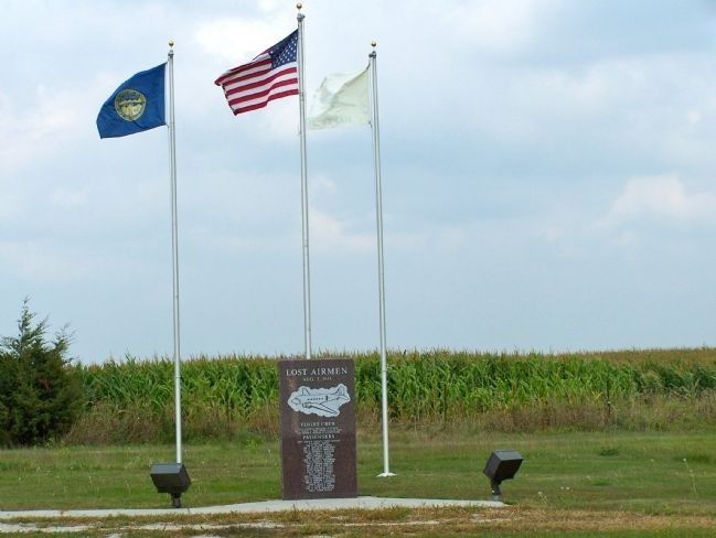
On August 3, 1944, a C-47 transport carrying twenty-eight men of the U.S. Army Air Forces crashed in a ravine six miles southwest of Naper during a severe storm. There were no survivors. It was the largest single military air disaster in Nebraska history. The plane was in flight from the Bruning, Nebraska, Army Air Field to Pierre, South Dakota, where the men would complete gunnery training before going overseas. A monument in nearby Knollcrest Cemetery honors their sacrifice.

(Disasters • War, World II) Includes location, directions, 2 photos, GPS coordinates, map.

Bryan Bridge

$
0
0
Nebraska, Cherry County, near Valentine
This arched cantilever truss bridge, connected in the center with a single pin, is the only one of its kind in the United States. It was built in 1932 by the Department of Public Works and named by the local citizenry in honor of Governor Charles Wayland Bryan. The bridge is 289 feet long, has a 24-foot roadway, and cost $55,564. It was designed by Josef Sorkin, who immigrated from Russia in 1923 and graduated from the University of Nebraska College of Engineering in 1929.

This particular design was chosen because it was aesthetically compatible with the surrounding environment of the Niobrara River Valley. The Bryan Bridge was selected as the “Most Beautiful Steel Bridge of 1932 in Class C” by the American Institute of Steel Construction, and was the first bridge between Wisconsin and the Pacific Coast to receive such an award.

In 1988 the bridge was listed in the National Register of Historic Places, and in 1995 it was designated as a State Historic Civil Engineering Landmark by the Nebraska Section of the American Society of Civil Engineers.

(Bridges & Viaducts) Includes location, directions, 4 photos, GPS coordinates, map.

Hamill Terrace

$
0
0
United Kingdom, Northern Ireland, County Antrim, Bushmills


Side A
Welcome to Hamill Terrace

Renowned as the gateway to the Giant's Causeway and for the oldest licensed whiskey distillery in the world, Bushmills has a unique heritage of historic buildings and mills.

Images (clockwise from top):
Bushmills Mills, Bushmills Distillery sign, The Causeway Tram c.1890

[Map and Causeway Coastal Route Journey linear locator]

Side B
Among many prizes, Bushmills whiskey was awarded a gold medal at the Paris Exhibition of 1889.

Award-winning village

Though people have lived in this area for centuries, it was in the 1600s that the first mills appeared here along the River Bush.

Under the influence of the Macnaghten family, who built several of the fine buildings you see today, like the Courthouse and Old School, Bushmills began to develop in the early 1800s. Seven water mills generated energy for the production of flax, paper and corn and the village also boasted an award-winning spade factory. The village grew as a tourist resort as part of the railway from Portrush to the Giant's Causeway and the increasing fame of the whiskey produced at the Old Bushmills Distillery.

Old Bushmills Distillery
On 20 April 1608 King James I granted Sir Thomas Phillips a license to distill 'uisce beatha' (the Irish for 'water of life', later anglicised as 'whiskey') here. In 1784 the Old Bushmills Distillery was officially recognised as a company, taking the pot still, the traditional method of distilling Irish whiskey, as its trademark. The world's oldest licensed distillery welcomes visitors for daily tours.

Giant's Causeway
Just two miles from here is one of the great wonders of the world, the Giant's Causeway, a UNESCO World Heritage Site. Its spectacular 40,000 interlocking basalt columns were created by volcanic activity millions of years ago (or the legendary Irish giant Fionn McCool!). This most famous of Northern Irish attractions can be reached from here on the Giant's Causeway and Bushmills Railway. The Giant's Causeway can also be reached by Park and Ride from the village.

Causeway School Museum
Among Bushmills many beautifully preserved old buildings is the Causeway School near the Giant's Causeway. It was designed by the architect Clough Williams-Ellis who also designed the famous Portmeirion village in Wales and several buildings in Cushendun in the Glens of Antrim.

Gold Medal
Among many prizes, Bushmills whiskey was awarded a gold medal at the Paris Exhibition of 1889, sharing the headlines with a temporary exhibit called the Eiffel Tower, which was unveiled at the same time.

St. Columba
The small tributary of the River Bush that provided the pure, peat-incensed water integral to the making of Bushmills whiskey is named St. Columb's Rill, after the early Christian missionary who preached in this area.

Dundarave House
The Macnaghten family home, was designed by the great architect Charles Lanyon, responsible for many of Belfast's most important Victorian buildings. It still stands above the village.

Images clockwise from top left:
Walkmill Falls, Map by Christopher Coles, Palmers Mill, Bushmills village


(Environment • Industry & Commerce • Man-Made Features • Settlements & Settlers) Includes location, directions, 3 photos, GPS coordinates, map.

Saint Mary’s Road

$
0
0
Arizona, Pima County, Tucson
Named in 1880 in reference to Arizona’s first hospital, Saint Mary’s Hospital. Established by the Sisters of Saint Joseph of Carondelet, the hospital housed 11 patients, four sister-nurses, and one doctor.

(Roads & Vehicles) Includes location, directions, 3 photos, GPS coordinates, map.

1964 Earthquake

$
0
0
Alaska, Anchorage Borough, Girdwood
This cabin was part of the original Portage town site. The small coastal towns of Girdwood and Portage located on Turnagain Arm were destroyed in the 1964 earthquake. Girdwood was later relocated a few miles inland, while Portage, which subsided below the high-water level, was abandoned entirely.

(Disasters) Includes location, directions, 4 photos, GPS coordinates, map.

Chief Kyan Totem Pole

$
0
0
Alaska, Ketchikan Gateway Borough, Ketchikan
Totem poles are carved to honor deceased ancestors record history, social events, and oral tradition. They were never worshipped as religious objects.

This totem is the second replication of the Chief Kyan Totem Pole. The original pole was carved in Ketchikan in the early part of the century and stood n Barney Way until the late 1920’s, when it was moved to the Pioneer Hall. In 1964, the aged pole was removed and replicated for the first time. This second replication was commissioned by the City of Ketchikan, to Tlingit master carver Israel Shotridge, who is a member of the Tongass Tribe. The pole was carved during the summer of 1992, with the assistance of apprentice Edwin DeWitt. Rededication and poleraising was July 3, 1993.

The figures on the pole represent the Crane, the Thunderbird and the Brown Bear. The original pole belonged to Tongass Tlingit Chief George Kyan whose Brown Bear crest can be seen on the pole. Chief Kyan’s Tlingit name was Yaansein. He was of the Wolf clan and was a member of the Tantakwaan tribe. Text approved by Tongass Tribe.

Visit Ketchikan’s other totem poles, and the only National Landmark collection of old, original totem poles at Totem Heritage Center, 601 Deermount Street

(Arts, Letters, Music • Native Americans) Includes location, directions, 5 photos, GPS coordinates, map.

Pillar of Stone

$
0
0
Australia, Victoria, Melbourne
This pillar of stone quarried from Stawell was placed here on the insistence of
The Hon. John Woods, M.P.
(born Liverpool England November 5th 1822, died Brighton Victoria April 2nd 1892; engineer, politician and inventor, commissioner International Exhibition 1880 and exhibition trustee 1881-1892) to express his indignation of the choice of New South Wales stone for Parliament House and to show the enduring qualities of local stone.

(Natural Resources) Includes location, directions, 3 photos, GPS coordinates, map.

Bridging the Mississippi

$
0
0
Minnesota, Anoka County, Anoka

The Mississippi River was an obstacle to overland travelers attempting to cross to the other side. From1855 to 1884 a flat bottomed cable ferry was maintained between Anoka and Champlin. For a time two ferry companies operated at this crossing and the competition was so fierce that sometimes passengers were offered free passage.

In 1884 a steel bridge was constructed with a swinging center section to permit steamboat travel on the river. Mr. Charles G. Jackson of Anoka was the first person to cross the bridge with a wagon and team of horses. At both ends of the bridge was a sign with bold letters which read, "Five dollar fine for driving or riding across this bridge faster than a walk."

With increasing automobile traffic, this structure was removed in 1929 and replaced by the existing concrete bridge measuring 995 feet in length. This bridge is on the national Register of Historic Places due to its innovative concrete architectural design with long arching spans.

(Bridges & Viaducts • Waterways & Vessels) Includes location, directions, 3 photos, GPS coordinates, map.

Fisgard Lighthouse

$
0
0
British Columbia, Capital Regional District, Colwood
The first permanent lighthouse on the Pacific coast of Canada, Fisgard was erected in 1859-60 by the British and Colonial Governments to guide mariners into Esquimalt Harbour. Brought from England with the first lightkeeper, the lantern became operational on November 16, 1860, and in 1928 it was made automatic. Captain G. H. Richards, R. N., recommended this site on the island names for H.M.S. FISGARD, on station in the Pacific from 1844 to 1847.

Ce phare fut le premier permanent sur la côte ouest du Canada. Il fut importé d'Angleterre et installé en 1859-1860 par les autorités britanniques et coloniales pour guider les marins dans le port d'Esquimalt. Il fut mis en service le 16 novembre 1860 et automatisé en 1928. Le capitaine G. H. Richards recommanda de le placer sur l'île Fisgard, nommé d'après le navire qui a été en station dans le Pacifique de 1844 à 1847.

(Waterways & Vessels) Includes location, directions, 2 photos, GPS coordinates, map.

Edwin Maw

$
0
0
Australia, Tasmania, Latrobe
The Lucas Platypus Experience is housed in a classified building on the register of the National Trust Estate. In 1858 George Atkinson built a licensed hotel “The Royal Charter Inn” on the present site. At the time he imported from Liverpool UK a prefabricated iron store as a warehouse.

Constructed of cast-iron columns, trusses, girts, window frames, it was clad with corrugated iron sheeting the walls and roof, the building stands on stone a foundation.

The columns have capitals and bases which are in echo classical mouldings all manufactured in the 1850’s by Edwin Maw and in a prefabricated format shipped out to Latrobe when the town and its working port were in their infancy.

It was one of three imported to the Australian colonies in 1858.

The building as part of the Lucas Hotel Complex are all classified and the warehouse has been preserved and rejuvenated externally to its original format, whilst internally it has been extensively remodeled to house the LUCAS Platypus Experience.

Specifications

12.350 metres long x 8.000 metres wide
5 Bays x 3 Bays of corrugated iron
devided (sic) by cast iron pilasters
3.035 metres high.

(Industry & Commerce) Includes location, directions, 4 photos, GPS coordinates, map.
Viewing all 103834 articles
Browse latest View live


Latest Images