October 31, 2017, 6:06 pm
Tendoy, Idaho.![]()
When Lewis learned that Clark had found the Salmon River un-navigable, buying more horses became a top priority. He'd already bought fifteen, but he needed twice that many to carry the Expedition's baggage. But enemy raiders . . .
(Animals • Exploration • Native Americans) Includes complete text, location, directions, 2 photos, GPS coordinates, map.
↧
↧
October 31, 2017, 6:07 pm
Tendoy, Idaho.![]()
This community is named for a great man: Tendoy, chief of the Lemhi Shoshone from 1863 to 1907. During the Nez Perce , Bannock and Sheepeater troubles of the 1870s, Tendoy preserved the peace in Lemhi County. In gratitude, . . .
(Native Americans) Includes complete text, location, directions, 4 photos, GPS coordinates, map.
↧
October 31, 2017, 6:39 pm
Shelburne, Vermont.![]()
The distinctive diamond-shaped interior framing of this structure gives Diamond Barn its name. The building has housed a variety of exhibits, from brass foundry patterns to folk art. Today, the lower level of the building . . .
(Arts, Letters, Music • Man-Made Features) Includes complete text, location, directions, 2 photos, GPS coordinates, map.
↧
October 31, 2017, 7:18 pm
near Tendoy, Idaho.![]()
Lewis and Clark gave Sacajawea a miracle: a return home for the first since her kidnapping several years earlier. She gave them as much: a Lemhi Shoshone interpreter and an advocate for the Expedition in buying Lemhi horses. . . .
(Exploration • Native Americans) Includes complete text, location, directions, 2 photos, GPS coordinates, map.
↧
October 31, 2017, 7:28 pm
Shelburne, Vermont.![]()
The Lighthouse was located a mile off Colchester Point in Lake Champlain, marking the location of three reefs: Colchester Reef, Colchester Shoals, and Hogback Reef. The building was designed in 1869 by Albert Dow, a . . .
(Communications • Man-Made Features • Waterways & Vessels) Includes complete text, location, directions, 3 photos, GPS coordinates, map.
↧
↧
October 31, 2017, 7:30 pm
near Tendoy, Idaho.![]()
About 50 million years ago, this was one of the most violent landscapes on Earth. A sub-surface mass of molten rock rose and subsided in cycles, spewing gas, mineral fragments and ash in explosions hundreds of times more . . .
(Natural Features) Includes complete text, location, directions, 2 photos, GPS coordinates, map.
↧
October 31, 2017, 7:53 pm
Vicksburg National Military Park, Mississippi.![]()
On December 12, 1862, the ironclad boat Cairo was sunk in the Yazoo River while mine-clearing. The vessel was found in 1956. It was raised, restored and relocated here. The Cairo is the only remaining ironclad of its type in . . .
(War, US Civil • Waterways & Vessels) Includes complete text, location, directions, 3 photos, GPS coordinates, map.
↧
October 31, 2017, 7:53 pm
Vicksburg National Military Park, Mississippi.![]()
Meet the deadline or pay $200 a day. James Eads had agreed to these terms for the construction of seven new ironclads. To speed production, a partner shipyard built three of the boats, including the one in front of you. . . .
(War, US Civil • Waterways & Vessels) Includes complete text, location, directions, 4 photos, GPS coordinates, map.
↧
October 31, 2017, 7:53 pm
Vicksburg National Military Park, Mississippi.![]()
On December 12, 1862, Cairo was part of a mine-clearing expedition on the Yazoo River. Her commander, hearing small arms fire coming from up ahead, steamed around the rest of the boats and into unexplored waters. Suddenly, . . .
(War, US Civil • Waterways & Vessels) Includes complete text, location, directions, 3 photos, GPS coordinates, map.
↧
↧
October 31, 2017, 9:16 pm
Vicksburg, Mississippi.![]()
Capt. T. N. Johnston. ?A detachment of the company served two? 10-inch Columbiads in a position, not in the park? about 150 yards northwest of this tablet, from ?May 18 to the end of the defense, July 4, 1863.? They were . . .
(War, US Civil • Waterways & Vessels) Includes complete text, location, directions, 4 photos, GPS coordinates, map.
↧
October 31, 2017, 9:16 pm
Vicksburg National Military Park, Mississippi.![]()
The first section of the company, under Lieuts. T.H. Cunningham and B.T. Mathews, served two 12-pounder howitzers in this position from about June 15 to the end of the defense, July 4, 1863.
(War, US Civil) Includes location, directions, 3 photos, GPS coordinates, map.
↧
October 31, 2017, 9:48 pm
Vicksburg National Military Park, Mississippi.![]()
In mid-19th century America, rivers were highways. And the Mississippi was the greatest of them all—the nation's main artery for commerce leading all the way to the Gulf of Mexico. By early 1863, two Confederate strongholds . . .
(Railroads & Streetcars • War, US Civil • Waterways & Vessels) Includes complete text, location, directions, 3 photos, GPS coordinates, map.
↧
October 31, 2017, 10:07 pm
Vicksburg National Military Park, Mississippi.![]()
Capt. T. N. Johnston. A detachment of the company served one 3-inch rifle in this position, Fort Hill, from May 19 to the end of defense, July 4, 1863.
(War, US Civil) Includes location, directions, 3 photos, GPS coordinates, map.
↧
↧
October 31, 2017, 10:30 pm
Vicksburg National Military Park, Mississippi.![]()
On May 19, 1863, the 55th Ilinois Infantry was pinned down by enemy fire and running out of ammunition. Orion P. Howe, a 14-year-old musician, volunteered to run back and get more. On the way, he was wounded. He found . . .
(Heroes • War, US Civil) Includes complete text, location, directions, 3 photos, GPS coordinates, map.
↧
November 1, 2017, 8:55 am
Leesville, Louisiana.![]()
(center panel) A Back Door of the United States Throughout its history, Burr Ferry has stood as an important location in western Louisiana. Many Texas cattlemen relied on Burr Ferry to cross the Sabine river in order to . . .
(Industry & Commerce • Settlements & Settlers • War, US Civil • Waterways & Vessels) Includes complete text, location, directions, 3 photos, GPS coordinates, map.
↧
November 1, 2017, 9:07 am
Lebanon, Tennessee.![]()
Livesay Mill was built in 1879 on the Clinch River at Kyles Ford near the Tennessee Virginia State Line in Hancock County. The Grist Mill was water powered using a pair of grinding stones to grind corn for meal and wheat for . . .
(Industry & Commerce • Settlements & Settlers) Includes complete text, location, directions, 2 photos, GPS coordinates, map.
↧
November 1, 2017, 9:12 am
Natchitoches, Louisiana.![]()
About 2 miles NW occupied 1844-45 by the 4th Infantry Regiment part of the "Army of Observation" to be near the Texas border should hostilities occur with Mexico. The camp located on the old Texas Road. Lt. Ulysses S. Grant . . .
(Forts, Castles • War, Mexican-American) Includes complete text, location, directions, 3 photos, GPS coordinates, map.
↧
↧
November 1, 2017, 9:16 am
Natchitoches, Louisiana.![]()
Beneath this building, former site of the Church of Saint Francis, the first Catholic Church in Natchitoches, lie the remains of The Chevalier Louis Juchereau De Saint Denis. Born at Quebec September 17, 1676, died at . . .
(Churches, Etc. • Colonial Era • Exploration • Settlements & Settlers) Includes complete text, location, directions, 3 photos, GPS coordinates, map.
↧
November 1, 2017, 9:22 am
Leesville, Louisiana.![]()
At the 24th annual session of the Sabine Association, Oct. 16, 1871, delegates from the First District petitioned for Letters of Dismission for the purpose of forming the Vernon Baptist Association. Signing for the churches . . .
(Churches, Etc.) Includes complete text, location, directions, 2 photos, GPS coordinates, map.
↧
November 1, 2017, 9:28 am
Rosepine, Louisiana.![]()
Incorporated December 24, 1902 by proclamation of Governor William Wright Heard. town established on Sections 3 and 4 of Township 25, Range 9W. During the Vernon Parish lumber boom, Rosepine consisted of a school, drugstore, . . .
(Political Subdivisions) Includes complete text, location, directions, 2 photos, GPS coordinates, map.
↧
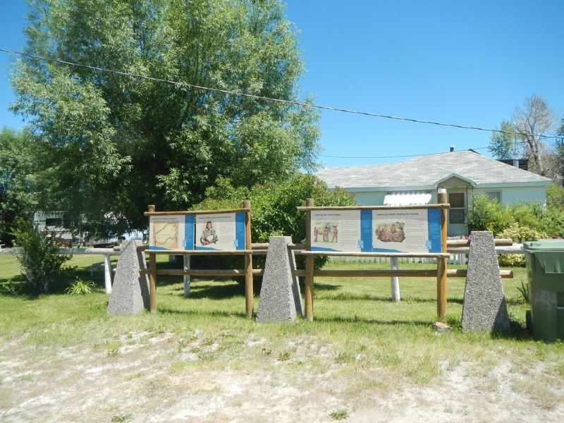 When Lewis learned that Clark had found the Salmon River un-navigable, buying more horses became a top priority. He'd already bought fifteen, but he needed twice that many to carry the Expedition's baggage. But enemy raiders . . .
  This community is named for a great man: Tendoy, chief of the Lemhi Shoshone from 1863 to 1907. During the Nez Perce , Bannock and Sheepeater troubles of the 1870s, Tendoy preserved the peace in Lemhi County. In gratitude, . . .
  The distinctive diamond-shaped interior framing of this structure gives Diamond Barn its name. The building has housed a variety of exhibits, from brass foundry patterns to folk art. Today, the lower level of the building . . .
  Lewis and Clark gave Sacajawea a miracle: a return home for the first since her kidnapping several years earlier. She gave them as much: a Lemhi Shoshone interpreter and an advocate for the Expedition in buying Lemhi horses. . . .
  The Lighthouse was located a mile off Colchester Point in Lake Champlain, marking the location of three reefs: Colchester Reef, Colchester Shoals, and Hogback Reef. The building was designed in 1869 by Albert Dow, a . . .
  About 50 million years ago, this was one of the most violent landscapes on Earth. A sub-surface mass of molten rock rose and subsided in cycles, spewing gas, mineral fragments and ash in explosions hundreds of times more . . .
  On December 12, 1862, the ironclad boat Cairo was sunk in the Yazoo River while mine-clearing. The vessel was found in 1956. It was raised, restored and relocated here. The Cairo is the only remaining ironclad of its type in . . .
  Meet the deadline or pay $200 a day. James Eads had agreed to these terms for the construction of seven new ironclads. To speed production, a partner shipyard built three of the boats, including the one in front of you. . . .
  On December 12, 1862, Cairo was part of a mine-clearing expedition on the Yazoo River. Her commander, hearing small arms fire coming from up ahead, steamed around the rest of the boats and into unexplored waters. Suddenly, . . .
  Capt. T. N. Johnston. ?A detachment of the company served two? 10-inch Columbiads in a position, not in the park? about 150 yards northwest of this tablet, from ?May 18 to the end of the defense, July 4, 1863.? They were . . .
  The first section of the company, under Lieuts. T.H. Cunningham and B.T. Mathews, served two 12-pounder howitzers in this position from about June 15 to the end of the defense, July 4, 1863.
 In mid-19th century America, rivers were highways. And the Mississippi was the greatest of them all—the nation's main artery for commerce leading all the way to the Gulf of Mexico. By early 1863, two Confederate strongholds . . .
  Capt. T. N. Johnston. A detachment of the company served one 3-inch rifle in this position, Fort Hill, from May 19 to the end of defense, July 4, 1863.
 On May 19, 1863, the 55th Ilinois Infantry was pinned down by enemy fire and running out of ammunition. Orion P. Howe, a 14-year-old musician, volunteered to run back and get more. On the way, he was wounded. He found . . .
  (center panel) A Back Door of the United States Throughout its history, Burr Ferry has stood as an important location in western Louisiana. Many Texas cattlemen relied on Burr Ferry to cross the Sabine river in order to . . .
  Livesay Mill was built in 1879 on the Clinch River at Kyles Ford near the Tennessee Virginia State Line in Hancock County. The Grist Mill was water powered using a pair of grinding stones to grind corn for meal and wheat for . . .
  About 2 miles NW occupied 1844-45 by the 4th Infantry Regiment part of the "Army of Observation" to be near the Texas border should hostilities occur with Mexico. The camp located on the old Texas Road. Lt. Ulysses S. Grant . . .
  Beneath this building, former site of the Church of Saint Francis, the first Catholic Church in Natchitoches, lie the remains of The Chevalier Louis Juchereau De Saint Denis. Born at Quebec September 17, 1676, died at . . .
  At the 24th annual session of the Sabine Association, Oct. 16, 1871, delegates from the First District petitioned for Letters of Dismission for the purpose of forming the Vernon Baptist Association. Signing for the churches . . .
  Incorporated December 24, 1902 by proclamation of Governor William Wright Heard. town established on Sections 3 and 4 of Township 25, Range 9W. During the Vernon Parish lumber boom, Rosepine consisted of a school, drugstore, . . .


