Mississippi, Lee County, near Baldwyn![]()
Long before Civil War soldiers fought at this site in 1864, this land was part of the Chickasaw Nation. Tishomingo, whose name derived from the Chickasaw title
tishu minko meaning "speaker for the chief" or "assistant chief" in the Chickasaw language, lived near here and was a prominent leader of the Chickasaws in this district.
Tishomingo was born as early as the 1730s, probably at Chickasaw Old Town in what is now northwest Tupelo. Tishomingo was a warrior and a staunch defender of Chickasaw lands and sovereignty. Chickasaws fought alongside American troops in numerous conflicts after the American Revolution, notably in the Northwest Indian Confederacy War in the 1790s and in the War of 1812. Tishomingo fought with distinction against the Creeks in the Red Stick War portion of the latter conflict in 1813-1814. Despite this service, the Chickasaws were forced to sell their lands in Mississippi to the U.S. government because of the influx of white settlers.
In the 1830s, all of the Southeastern tribes were relocated to Indian Territory in present day Oklahoma. Despite the removal of the Chickasaw Indians from this area, their legacy lives on.
Chief Tishomingo's name is still attached to this creek, a town, and a Mississippi county which originally extended from the Tennessee River to within a few miles of here. The tribal capital in the west was also named for him and persists today as Tishomingo, Oklahoma. Chief Tishomingo died in present-day Arkansas about 1840 while assisting tribal members on the Trail of Tears. The location of his grave is unknown.
Bottom Quote: "Although but little is known beyond the limits of his nation, yet he was a man that had seen wars and fought battles - stood high among his own people as a brave and good man." -
Tishomingo's obituary, 1841
Upper Right Corner Map: The lands of the Chickasaw Nation encompassed much of northern Mississippi. - "Map of the States of Mississippi, Louisiana, and the Arkansas Territory," 1832,
An Atlas of the United States of North America, David Rumsey Map Collection.
Center Drawing: The only known portrait of Chief Tishomingo of the Chickasaw Indians.
Research Division of the Oklahoma Historical Society.Right Side Map: Chief Tishomingo's homesite is just a little south of here, near the bank of what is now Tishomingo Creek. A monument marks the location.
(Native Americans • War of 1812 • Wars, US Indian) Includes location, directions, 2 photos, GPS coordinates, map.
 This area’s climate includes dramatic fluctuations. As you imagine yourself ranching here, consider the effects of one winter during the heydays of the open ranch.
 The hills held ancient secrets for paleontologists. The two hills in the distance don’t look like anything special. Even up close the untrained eye will see nothing astounding. But a sandstone layer near the bases of the hills has yielded one of the richest concentrations of fossilized mammal remains ever discovered.
 The highest wind ever observed by man was recorded here. From 1932 to 1937 the Mt. Washington Conservatory was operated in the summit stage office then occupying this site in a great storm of April 12, 1934. The crew’s instruments measured a wind velocity of 231 miles per hour.
 Dedicated March 12, 1999. Mike Huckabee Governor, Jim Hill State Senator, Sandra Rodgers State Representative. Major Benefactors-Century Tube, Inc, Swepco, Entergy, Sanyo Manufacturing Corp, Future Tech Intel, Nina Wang, Ben & Martha Bryant, Nissan North America, Reliant Energy Arkla, International Paper Co., Dr Elias & Jody Ghanam Family, Selma & Walter Kaye, United Parcel Service.
 After Horseshoe Bend defeat, Creeks ceded millions of acres to United States. Cotton was in great demand. This area ideal for crop which is still planted on peninsular across river. In 1817, lands went on sale. Andrew Dexter, Massachusetts lawyer, founded village of New Philadelphia (Capitol Area). John Scott and Georgians established Alabama Town on bluff to west. Year later, this group acquired land adjacent to Dexter's, settled East Alabama Town. (Commerce Street). 1819, latter two joined to form Montgomery which developed as major market center. City became state capital. 1846: Confederate capital. Feb - May, 1861; birthplace of Civil Rights, 1955.
 Much of the Old Trace had been abandoned by the start of the civil war. However, the war did leave its mark on the Trace as it did upon the rest of the South, as soldiers marched, camped and fought along portions of this historic old road.
 In April 1950, Alabama’s last two living Confederate veterans met here to discuss shared experiences of the Civil War. Local resident Col. Pleasant ‘Riggs’ Crump was visited by Gen. James Moore of Selma, commander of the Alabama chapter of the United Confederate Veterans. Present at the surrender at Appomattox 85 years earlier,, Crump had returned to the Lincoln area after the Civil War. He was a member of the Refuge Baptist Church which he served as deacon for 71 years, and was buried in this cemetery after his death in 1951 at the age of 104.
 Buried just east of this site. “Sonny” Montgomery served in the Mississippi State Senate 1956-1966 and the U. S. House of Representatives 1967-1997. A retired Major General in the Mississippi National Guard. Montgomery championed military and veterans issues including the 1984 Montgomery G. I. Bill.
 1861-1865
Mounted by Camp Benning, U.C.V.
Aug. 1898
1861-1865
Mounted by Camp Benning, U.C.V.
Aug. 1898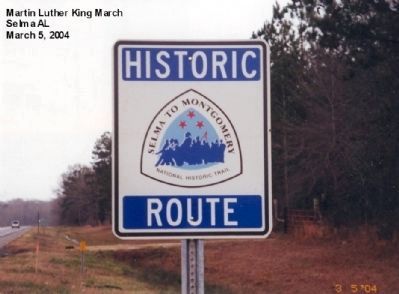 Hall Farm
March 21, 1965
Hall Farm
March 21, 1965 Robert Gardner Farm
March 23, 1965
Robert Gardner Farm
March 23, 1965 In 1672 Louis Joliet and Father Jacques Marquette were commissioned by King Louis XIV to discover the course of the Mississippi River. On June 17, 1673, the expedition entered the Mississippi from the Wisconsin River and began its descent by canoe.
 The Infantry Honors
 Born: 17 March 1925 Juneau, Alaska.
  This cemetery was the family burying ground on Good Hope Plantation granted in part by King George III to John Twiggs Brigadier General in the Revolutionary Army afterward Major General of Militia
 Founded in 1946 by Colonel Joseph Mackey, Mackey Airlines became (August 5, 1952) the first certificated carrier in Broward authorized to engage in scheduled foreign transportation. Operations began January 2, 1953 between Fort Lauderdale, West Palm Beach and Nassau, N.P. Bahamas. Increased certification later allowed service to all Bahama Islands from Fort Laudrdale-Hollywood, Miami, West Palm Beach, St. Petersburg, Tampa and Jacksonville. Mackey operated without mail pay or subsidy. Passengers increased from 15,000 to 150,000 annually. Mackey and Eastern Airlines merged January 1, 1967.
 Striking Ingersoll's brigade 5 miles east, Forrest overran the position to which they had retired on high ground to the south. Ingersoll and his artillery were captured. Returning 2 weeks later, Forrest rested briefly here, then crossed the river at Clifton, brushing aside the 6th Tennessee Cavalry(Federal).
 Long before Civil War soldiers fought at this site in 1864, this land was part of the Chickasaw Nation. Tishomingo, whose name derived from the Chickasaw title tishu minko meaning "speaker for the chief" or "assistant chief" in the Chickasaw language, lived near here and was a prominent leader of the Chickasaws in this district.


