Virginia, Alexandria
![]() The concrete foundations you see here were part of a craneway servicing two shipways and launch sites -- elements of an enormous World War I-era shipyard. To speed delivery of cargo ships needed for the war effort, the Virginia Shipbuilding Corporation hired thousands of workers and ordered tens of thousands of tons of steel. The yard's 7,000 workers and support staff used mass production techniques developed by the auto industry to move materials and speed assembly of simple, per-fabricated steel components. The first ship, the SS Gunston Hall, took just over a year to complete.
The concrete foundations you see here were part of a craneway servicing two shipways and launch sites -- elements of an enormous World War I-era shipyard. To speed delivery of cargo ships needed for the war effort, the Virginia Shipbuilding Corporation hired thousands of workers and ordered tens of thousands of tons of steel. The yard's 7,000 workers and support staff used mass production techniques developed by the auto industry to move materials and speed assembly of simple, per-fabricated steel components. The first ship, the SS Gunston Hall, took just over a year to complete.
Calling All Hands
Employees of the shipyard knew they were racing the clock to build the ships needed to win the war. To turn out ships as quickly as possible, the U.S. Emergency Fleet Corporation sought both experienced shipbuilders, and anyone who could use construction tools.
(Industry & Commerce • War, World I • Waterways & Vessels) Includes location, directions, 6 photos, GPS coordinates, map.
 The concrete foundations you see here were part of a craneway servicing two shipways and launch sites -- elements of an enormous World War I-era shipyard. To speed delivery of cargo ships needed for the war effort, the Virginia Shipbuilding Corporation hired thousands of workers and ordered tens of thousands of tons of steel. The yard's 7,000 workers and support staff used mass production techniques developed by the auto industry to move materials and speed assembly of simple, per-fabricated steel components. The first ship, the SS Gunston Hall, took just over a year to complete.
Calling All Hands
Employees of the shipyard knew they were racing the clock to build the ships needed to win the war. To turn out ships as quickly as possible, the U.S. Emergency Fleet Corporation sought both experienced shipbuilders, and anyone who could use construction tools.
(Industry & Commerce • War, World I • Waterways & Vessels) Includes location, directions, 6 photos, GPS coordinates, map.


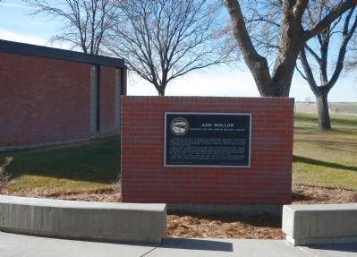 Although some wagon trains continued to follow the South Platte, most crossed at one of several fords in this area and took a northwesterly route toward the North Platte River. The trail then followed the North Platte Valley through the remainder of Nebraska. Today’s traveler, by following U.S. Highway 26 northwest of Ogallala, will encounter several noted landmarks along this portion of the Platte River Road.
On of these is Ash Hollow, a picturesque canyon, near present-day Lewellen. Because of the steepness of the descent, this part of the trail presented one of the most serious obstacles yet faced by the emigrants. Offering spectacular scenery as well as wood and water, Ash Hollow is mentioned in many overland diaries. Several graves, including that of young Rachel Pattison who died of cholera in 1849, testify to the rigors of the overland journey.
Although some wagon trains continued to follow the South Platte, most crossed at one of several fords in this area and took a northwesterly route toward the North Platte River. The trail then followed the North Platte Valley through the remainder of Nebraska. Today’s traveler, by following U.S. Highway 26 northwest of Ogallala, will encounter several noted landmarks along this portion of the Platte River Road.
On of these is Ash Hollow, a picturesque canyon, near present-day Lewellen. Because of the steepness of the descent, this part of the trail presented one of the most serious obstacles yet faced by the emigrants. Offering spectacular scenery as well as wood and water, Ash Hollow is mentioned in many overland diaries. Several graves, including that of young Rachel Pattison who died of cholera in 1849, testify to the rigors of the overland journey. Traveling northwest from Ash Hollow, the emigrants encountered three natural features of the North Platte Valley which became well-known milestones. First was Court House Rock, rising abruptly from the plains as the vanguard of the bluffs farther on. Observers likened this gigantic formation to some great public building or medieval castle.
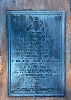 Minguannan Indian Town
 In this age of technological innovation, the act of crossing a river may be taken for granted. And yet, there is always a magic to bridges: How is the river parted to lay the foundation? What stops the bridge from washing downstream? How are so many cars and trucks supported?
 Lieu qui offre la plus belle vue sur le bas du village, la plaine agricole, la vallée du Calovon, les villages voisins, les monts de Vaucluse et le mont Ventoux.
Ce lieu est l’emplacement de la Chapelle Notre Dame de Sept Douleurs bâtie par la Confrérie des Pénitents Blancs. Elle fut aliénée pendant la revolution et revint à la famille de Rouvil, puis à la collectivité lors de l’achat de l’hôtel.
Le 11 juin 1909, un séisme provoqua deux importantes fissures sur la façade ouest de l’èglise haute et des lézardes sur les murs de la chapelle; celle-ci fut démolie en 1915 pour cause de «danger public» . Sous vos pieds, une belle voûte témoigne encore de son existence.
79 marches vous séparent encore parent de la Vieille Eglise, à l’ombre de cèdres centenaires.
Lieu qui offre la plus belle vue sur le bas du village, la plaine agricole, la vallée du Calovon, les villages voisins, les monts de Vaucluse et le mont Ventoux.
Ce lieu est l’emplacement de la Chapelle Notre Dame de Sept Douleurs bâtie par la Confrérie des Pénitents Blancs. Elle fut aliénée pendant la revolution et revint à la famille de Rouvil, puis à la collectivité lors de l’achat de l’hôtel.
Le 11 juin 1909, un séisme provoqua deux importantes fissures sur la façade ouest de l’èglise haute et des lézardes sur les murs de la chapelle; celle-ci fut démolie en 1915 pour cause de «danger public» . Sous vos pieds, une belle voûte témoigne encore de son existence.
79 marches vous séparent encore parent de la Vieille Eglise, à l’ombre de cèdres centenaires. L’hôtel de Rouvil appartenait à une vieille famille de Bonnieux. Cet hôtel particulier est devenu la nouvelle maison commue en 1859, maison commune initialement installée rue Droite «rue étroite et escarpée qui n’est plus convenable au service de la population et aux besoins des services . Pour des raisons similaires, la mairie sera transférée en bas du village en 2006.
Une tour devait être construite place de la justice pour y recevoir la nouvelle horloge. Ce projet est abandonné au profit de l’hôtel de Rouvil; la façade nord ouest porte l’horloge et un clocheton à campanile en fer forgé.
La salle des mariages est un ancien salon d’apparat. Une cave taillée dans la roche témoigne d’une utilisation plus ancienne. Après un large escalier, un portail, à l’entablement ornementé, encadré de deux pilastres et surmonté d’un fronton à corniche, s’ouvre sur une petite cour intérieure.
Face à l’hôtel, une belle demeure, vraisemblablement construite sur des assises médiévales, a été l’object de nombreux remaniements au cours des siècles (porte d’entrée en plein cintre, encadrement traité à la Floretine).
Côté nord, une autre entrée donne sur un jardin en une habitation qui à abrité au XIXeme siècle l’ecole de garcons, puis dans les années 50/60 l’école ménagère de jeudi pour filles.
Les escaliers en calade ont été restaurés en 2000; c’est la voie royale pour accéder à grand peine à l’eglise et au cimetière! A Bonnieux, disait-on: «les morts enterrent les vivants»!
L’hôtel de Rouvil appartenait à une vieille famille de Bonnieux. Cet hôtel particulier est devenu la nouvelle maison commue en 1859, maison commune initialement installée rue Droite «rue étroite et escarpée qui n’est plus convenable au service de la population et aux besoins des services . Pour des raisons similaires, la mairie sera transférée en bas du village en 2006.
Une tour devait être construite place de la justice pour y recevoir la nouvelle horloge. Ce projet est abandonné au profit de l’hôtel de Rouvil; la façade nord ouest porte l’horloge et un clocheton à campanile en fer forgé.
La salle des mariages est un ancien salon d’apparat. Une cave taillée dans la roche témoigne d’une utilisation plus ancienne. Après un large escalier, un portail, à l’entablement ornementé, encadré de deux pilastres et surmonté d’un fronton à corniche, s’ouvre sur une petite cour intérieure.
Face à l’hôtel, une belle demeure, vraisemblablement construite sur des assises médiévales, a été l’object de nombreux remaniements au cours des siècles (porte d’entrée en plein cintre, encadrement traité à la Floretine).
Côté nord, une autre entrée donne sur un jardin en une habitation qui à abrité au XIXeme siècle l’ecole de garcons, puis dans les années 50/60 l’école ménagère de jeudi pour filles.
Les escaliers en calade ont été restaurés en 2000; c’est la voie royale pour accéder à grand peine à l’eglise et au cimetière! A Bonnieux, disait-on: «les morts enterrent les vivants»! Anciennement rue des Marchands, c’était l’artère commerçante du village.
-Fontaine du cafe, encore un! Il paraît que l’eau (ou l’absinthe...) y était meilleure! La fontaine est adossée à une belle demeure bâtie sur voûte autour des XIVeme et XVeme siècles.
-Passage de la juiverie: restauration en 2009. Ce petit espace, dans lequel on confinait les Juifs au Moyen Age, était fermé le soir, ce qui montre qu’ils étaient soumis à une juridiction ecclésiastique spéciale, et seulement tolérés. En 1656, le Juifs de Bonnieux reçurent l’ordre de se retirer.
-Maison privée, rue Emile APPY: cette ancienne maison forte située prés de remparts, constituait une importante protection intérieure pour l’accès nord à la cité. Si vous empruntez la rue Emile APPY vous pourrez découvrir la Portalet, ancienne porte de la ville, et, au dessus, la salle de gardes. L’édifice a subi de nombreux remaniements au cours des siècles. A l’intérieur, on trouve caves, voûtes remarquables, citernes, silos, pressoir, meules et tout un ensemble d’aménagements rupestres.
Anciennement rue des Marchands, c’était l’artère commerçante du village.
-Fontaine du cafe, encore un! Il paraît que l’eau (ou l’absinthe...) y était meilleure! La fontaine est adossée à une belle demeure bâtie sur voûte autour des XIVeme et XVeme siècles.
-Passage de la juiverie: restauration en 2009. Ce petit espace, dans lequel on confinait les Juifs au Moyen Age, était fermé le soir, ce qui montre qu’ils étaient soumis à une juridiction ecclésiastique spéciale, et seulement tolérés. En 1656, le Juifs de Bonnieux reçurent l’ordre de se retirer.
-Maison privée, rue Emile APPY: cette ancienne maison forte située prés de remparts, constituait une importante protection intérieure pour l’accès nord à la cité. Si vous empruntez la rue Emile APPY vous pourrez découvrir la Portalet, ancienne porte de la ville, et, au dessus, la salle de gardes. L’édifice a subi de nombreux remaniements au cours des siècles. A l’intérieur, on trouve caves, voûtes remarquables, citernes, silos, pressoir, meules et tout un ensemble d’aménagements rupestres. In memory of Allan Pinkerton, born in Glascow, Scotland, August 25th 1819. Died in Chicago, Illinois July 1st 1884. Aged 65 years.
 In 1766, English and French Canadian traders wintered near this site. They must have puzzled over these strange earthen shapes-or others even nearer their cabin. The traders could not have known that the humble grave markers were vestiges of a prehistoric mound-building culture which spread across most of eastern North America 1,000 years before Christ.
Discovery of larger mounds in Ohio in the late 1700’s led some historians to claim the “Mound Builders” were remnants of Old World tribes. Others insisted the builders were survivors of the fabled lost continent of Atlantis.
In 1766, English and French Canadian traders wintered near this site. They must have puzzled over these strange earthen shapes-or others even nearer their cabin. The traders could not have known that the humble grave markers were vestiges of a prehistoric mound-building culture which spread across most of eastern North America 1,000 years before Christ.
Discovery of larger mounds in Ohio in the late 1700’s led some historians to claim the “Mound Builders” were remnants of Old World tribes. Others insisted the builders were survivors of the fabled lost continent of Atlantis.
 Le nom gallo-romain est Bitrona. On trouve ensuite Castrum Bonilis (Xeme S.) Bonils (XIIeme S.) de Bonilis (XIVeme S.).
La forme provençale est Bonieux
La préhistoire est ici présente en de nombreux lieux (habitants néolithiques, notamment sur les franges du plateau de Claparedes). L’agglomération gallo-romaine se situait aux abords de la plaine (villas romaines, déterminées en plusieurs lieux): la partie surélevée ayant été oppidum celto-ligure;
c’est autour de cette zone mieux protégée que s’édifie la ville du Moyen-Age. Au XIIIeme siècle, le château (Castellum, aujourd’hui Castellas), propriété de la puissante famille d’Agoult protège une communauté que les menaces permanentes venues de la plaine engagent à s’entourer de puissanrtes murailles en tours (Castrum). De la fin du XIIIeme siècle à la Révolution (1789) la ville appartient au domaine pontifical (Comtat Venaissin) ce qui lui donne du fait de cette position particulière d’enclave, une place à part dans l’histoire de notre région.
A Voir Ou A Visiter
L’eglise Haute, à laquelle an peut accéder par un escalier de 86 marches. De l’Eglise romane originelle (XIIeme S.) subsistent duex travées sur lesquelles vient s’appuyer une construction du XVem siècle assez élégante. Al’intérieur beau rétable en bois doré du XVeme siècle.
L’eglise Neuve, (1879) renferme quatre primitifs du XVIeme siècle provenant de l’Eglise haute en représentant des scènes de la Passion.
A l’interieur du village:
Vesitiges des tours et remparts du XIIIeme siecle.
Hotel de Rouville (Mairie, XVIIIeme S.).
Vieilles rues et demeures nobles, ancien hôspital (XVIIIeme S.).
Dans la plaine, en junction avec la R.N. 100 Le Pont julien, (an III avant J.C.) belle construction tourjours utilisée, à trois arches ancien franchissement de la Voie Domitoemme qui doit son nom à la proximité de la Colonia Apta-Julia.
Le Prieure de Saint-Symphorien
La Tour Philippe, construction d’un original à la fin du XIXeme siècle.
La Forêt de Cedres, sentier de découverte de la nature établi par les soins du Parc Naturel de Lubéron.
Le nom gallo-romain est Bitrona. On trouve ensuite Castrum Bonilis (Xeme S.) Bonils (XIIeme S.) de Bonilis (XIVeme S.).
La forme provençale est Bonieux
La préhistoire est ici présente en de nombreux lieux (habitants néolithiques, notamment sur les franges du plateau de Claparedes). L’agglomération gallo-romaine se situait aux abords de la plaine (villas romaines, déterminées en plusieurs lieux): la partie surélevée ayant été oppidum celto-ligure;
c’est autour de cette zone mieux protégée que s’édifie la ville du Moyen-Age. Au XIIIeme siècle, le château (Castellum, aujourd’hui Castellas), propriété de la puissante famille d’Agoult protège une communauté que les menaces permanentes venues de la plaine engagent à s’entourer de puissanrtes murailles en tours (Castrum). De la fin du XIIIeme siècle à la Révolution (1789) la ville appartient au domaine pontifical (Comtat Venaissin) ce qui lui donne du fait de cette position particulière d’enclave, une place à part dans l’histoire de notre région.
A Voir Ou A Visiter
L’eglise Haute, à laquelle an peut accéder par un escalier de 86 marches. De l’Eglise romane originelle (XIIeme S.) subsistent duex travées sur lesquelles vient s’appuyer une construction du XVem siècle assez élégante. Al’intérieur beau rétable en bois doré du XVeme siècle.
L’eglise Neuve, (1879) renferme quatre primitifs du XVIeme siècle provenant de l’Eglise haute en représentant des scènes de la Passion.
A l’interieur du village:
Vesitiges des tours et remparts du XIIIeme siecle.
Hotel de Rouville (Mairie, XVIIIeme S.).
Vieilles rues et demeures nobles, ancien hôspital (XVIIIeme S.).
Dans la plaine, en junction avec la R.N. 100 Le Pont julien, (an III avant J.C.) belle construction tourjours utilisée, à trois arches ancien franchissement de la Voie Domitoemme qui doit son nom à la proximité de la Colonia Apta-Julia.
Le Prieure de Saint-Symphorien
La Tour Philippe, construction d’un original à la fin du XIXeme siècle.
La Forêt de Cedres, sentier de découverte de la nature établi par les soins du Parc Naturel de Lubéron.
 Campbell Hill is named for Charles D. Campbell of Bellefontaine, who owned this land from 1896 to 1937. A marble stone marker atop the hill, set in 1900 by the U.S. Coast and Geodetic Survey, marks it as the highest point in Ohio at an elevation of 1549.09 feet. In 1951, the federal government established the 664th Aircraft Control and Warning (AC&W) Squadron here as part of the North American Air Defense Command (NORAD). Its military and civilian operators used sophisticated radar and computer equipment to located and identify aircraft as friendly or suspicious, and relayed information to a central site in Battle Creek, Michigan. This Cold War site operated until 1969. It was converted to civilian use as a vocational education center in 1974.
 This hill was not a pleasant place during the 1870’s. It was covered with buffalo grass, prickly pear and soapweed and was used as a burying ground for drifters, troublemakers, and unknowns from 1872 until 1879. As early as 1879 newspapers were reporting that some people in Dodge City were dying with their boots on and were being buried where you are now standing. There were no ceremonies for the dead, no markers on the graves and wolves often dug up the bodies soon after burial. By 1879 when the city council ordered that all bodies be removed from this site, about 34 persons had been interred on Boot Hill. In 1916 most of the hill was excavated to make room for a new city swimming pool. You are now at what was the northwest corner of the original graveyard.


