Missouri, Jackson County, Kansas City![]() (Side A)
(Side A)
In 1821, Francois and Berenice Chouteau arrived from St. Louis to establish Kansas City's first commercial emporium, the "Chouteau Trading Post", and in effect to found Kansas City. Francois was the grandson of Pierre Laclede, founder of St. Louis, and his wife Berenice was the daughter of Pierre Menard, a prominent man of French descent. French traders and soldiers had gone upriver as far as the Platte, starting as early as 1680. In its earliest years, the location of the Post was called "Chez les Canses" -- meaning "at the village of the Kansa" -- and later it was referred to simply as "Chouteau's." The first Chouteau personnel, including Francois' assistant, Louis (GrandLouis) Bertholet, who arrived in 1820, located on the North bank of the Missouri River. Some remained there after the Post was erected on the South bank.
Chouteau descendants say the first religious services here were held at the Post, and the first burials were made nearby. The first Chouteau Post was located near the South end of the Chouteau Bridge considerably down river. It was soon swept away by a flood, and after each ruinous flood the Post was relocated further up the river bank, and to the West. Berenice Chouteau, the "mother and Grand Dame of Kansas City," was a woman of great courage and compassion. When young Francois was killed by a stampeding horse in 1838, Berenice continued on at the Post. An 1841 map drawn by Fr. Point, priest of the French-speaking Church of St. Francis Regis, founded by Berenice, shows the home of "Madame Chouteau" at the eastern tip of the settlement (nearby, at Third and Grand). During a severe cholera epidemic, she nursed the severely ill and dying children - black, white, and Indian, and made shrouds for those who died, including two of her own children, from her linens and her silk wedding gown! She outlived her nine children, and died in 1888 at the age of eighty seven, having gained the love and respect of all Kansas Citians.
(Side B)
En 1821, François et Bérénice Chouteau arrivèrent de St. Louis, afin de créer le premier établissement commercial, "la Maison Chouteau" et par là même pour fonder Kansas City. François était le petit fils de Pierre Laclede, le fondateur, de St. Louis, et son èpouse Bérénice était le fille de Pierre Menard, un homme important de souche française. Dès 1680, commerçants, et soldats français avait déjà remonté la rivière jusqu'à ce qui est aujourd'hui la rivière Platte. Durant les premières années de sa création, l'établissement s'est appelé "Chez les Canses" ce qui signifíe "le village des Kansa" - plus tard on l'appela simplement "Chez Chouteau." Les premiers employés de la Maison Chouteau, y compris l'adjoint de François, Louis Bertholet (dit Grand Louis) qui arriva en 1820, s'installèrent sur la rive nord du Missouri. Quelques uns restèrent sur place même après que l'établissement commercial fut construit sur la rive Sud.
Les descendants des Chouteau ont rapporté que les premiers services religieux ont été célébrés dans l'établissement et que les premiers enterrements ont été faits non loin. Le premier établissement Chouteau fut construit près de l'extrémité Sud de l'actuel pont Chouteau, très en aval de la rivière. La première construction fut rapidement emportée par une inondation, et après chaque crue dévastatrice l'établissement fut reconstruit plus haut sur la rive et vers l'ouest. Bérénice Chouteau "la mère et la Grand Dame de Kansas City" fut une femme pleine de courage et de compassion. Lorsque son mari François, encore jeune, fut tué par la ruade d'un cheval en 1838, Bérénice continua à tenir l'établissement. Une carte de 1841, établie par le révérend Point, prêtre à la paroisse St. Francis Regis fondée par Bérénice (où l'on parlait français), montre la maison de "Madame Chouteau" à l'extrémité Est des installations (près du carrefour de la 3ème rue et da l'avenue Grand). Durant une grave épidémie de choléra, elle soigna les enfants mourants et les plus sévèrement atteints - noirs, blancs ou Indiens et confectionna des linceuls pour les morts y compris deux de ses enfants avec ses vêtements et même avec sa robe de mariée en soie! Elle survécut à ses neuf enfants et mourut en 1888 à l'âge de 87 ans, en ayant acquis l'estime et le respect de tour les habitants de Kansas City.
(Industry & Commerce • Settlements & Settlers) Includes location, directions, 3 photos, GPS coordinates, map.
 The Hilleary-Magruder House was likely one of many sites in town where more than 200 British and American soldiers wounded in the Battle of Bladensburg were taken for treatment and convalescence. Built in 1742 by William Hilleary, later the home of a Scottish tobacco merchant, the house was occupied by medical doctors from 1803 to 1863.
 A wooden bridge just upriver became the focal point on August 24, 1814, when American and British forces clashed in the Battle of Bladensburg. The British approached from the east, clarifying their intent -- to invade Washington. The Americans formed three defensive lines: the first here to protect the bridge, the second along present-day 40th Avenue, and the third at Fort Lincoln Cemetery at the District Line. At 1:00p.m. the British stormed the bridge.
 Born 1854 in North Manchester in this house on Main Street. Was Governor of Indiana 1909-13. Under his leadership, Indiana General Assembly enacted legislation, called the "Marshall Constitution," to improve government efficiency by amending the Constitution. Indiana Supreme Court declared the legislation unconstitutional July 5, 1912.
 Church of the Brethren founded 1708 in Europe. By 1778, Brethren met annually to determine church policy. First annual meeting in Indiana was in Elkhart County 1852. North Manchester Church of the Brethren hosted annual meetings 1878, 1888, 1900; last two meetings held here in Harter's Grove. Had enormous social and economic impact on area.
 Tennessee
 Tennessee
 [Text on North Side of Monument]:
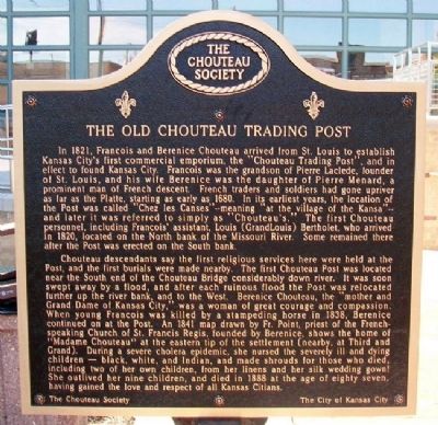
 A native of Georgia, Samuel W. Johnson established his first medical practice in Atlanta. After moving to Texas and settling in Corsicana, he became a respected community physician and was elected mayor in 1900. During his term in office the public library was established, thanks to the efforts of the city's women's clubs. Johnson was also instrumental in the early oil industry in Corsicana. His first wife, Kate Beaton, died in 1904. In 1910 he married Sarah Pace. Johnson moved to Dallas in 1910 and died there in 1922. He is buried in Corsicana's Oakwood Cemetery.
 The leader of the Mormon pioneers, Brigham Young, was born up the steep hill to the south on June 1, 1801. He eventually led his people from Illinois to Utah where he founded Salt Lake City in 1847 and 500 communities throughout the west. Young became the first territorial governor of Utah and the second president of the Church of Jesus Christ of Latter-Day Saints.
 Jean Baptiste Richardville (1761-1841) was principal chief of the Miami Tribe from 1812 to 1841. He signed six treaties with the United States ceding Miami land in Indiana. This house was built for him under one of the treaties.
 Even when blessed with good roads and good weather, crossing the Alleghenies on the Lincoln Highway was a challenge for the early motorist. Steep grades and winding roads resulted in overheated engines and severe cases of vertigo. Entrepreneurs along the Lincoln Highway’s many summits established business to respond to this dilemma. One of the most famous Lincoln Highway landmarks in Pennsylvania and in the country was the S.S. Grand View Point located ½ mile east of this point.
 This millstone is a remnant of the grist and saw mills built near here for Miami Indians by United States government as part of 1818 Treaty of St. Mary's. Treaty also established several Miami reservations in area. Possibly first industrial site in what became Wabash County.
 First lock west of summit level of Wabash and Erie Canal (connected Lake Erie with Ohio River in 1853). Known as Dickey Lock. Built as Lock 1, 1834-1835, of wood construction; renumbered Lock 4 as result of canal completion to Ohio line (1840). Remnants of arch culvert nearby. Canal important to founding of Roanoke.
 Born 1810 in what is now Huntington County. She was a granddaughter of Miami Chief Little Turtle. Her second husband was Antoine Revarre; her son Anthony Revarre, lived with her near Roanoke and acted as interpreter since she spoke only Miami. Most Miami were removed from Indiana 1846; 1850 act of Congress exempted her only son and other Miami people.
 Congregation founded 1836, serving Irish who immigrated to area to work on construction of Wabash and Erie Canal, 1834-1837. Many Irish bought land and stayed as permanent residents using their religious and cultural interests to build Lagro, originally platted 1834, into a thriving trade center. Church dedicated first building 1838; used for activities until razed in 1960s. This brick structure, built 1870-1873, designed in Victorian Gothic Style; original bell still in use. Brick made in Huntington and Lagro. Features include hand-carved altars and statues, stained glass windows, and oak and walnut curved stairway. Listed in National Register of Historic Places 1999.
 While A Slave She Nursed
 The Second of three defensive lines blocking the British advance on Washington stretched along here. It was located on the first set of hills overlooking the river. The American militia was unprepared to face seasoned war veterans. Holding firm against the initial assault at the bridge, the militia gave way as the British rushed again, pushing through the first two lines. Only the third remained.

 Francis Godfroy (1788-1840) was last war chief of the Miami Nation. Owner Mount Pleasant trading post and one of the wealthiest and most influential merchants in the West. Burials in cemetery are restricted to persons of Native American ancestry and their families.


