September 19, 2016, 6:13 pm
Williamsburg, Virginia.![]()
Capital-Frankfort Following possible visits to the area in the 17th century, particularly by Gabriel Arthur, actual exploration was not made until Thomas Walker went to the region in 1750. He was followed in 1751 by . . .
(Colonial Era • Settlements & Settlers • Exploration) Includes complete text, location, directions, 4 photos, GPS coordinates, map.
↧
↧
September 19, 2016, 6:27 pm
Rocky Mount, North Carolina.![]()
Operated the Douglas-Armstrong Drug Company in the Douglas Building that he developed circa 1916: prominently located, three blocks west, at the corner of NE Main St, and E Thomas St. It is the anchor building for the . . .
(Industry & Commerce • African Americans) Includes complete text, location, directions, 5 photos, GPS coordinates, map.
↧
September 19, 2016, 6:29 pm
Williamsburg, Virginia.![]()
Capital-Nashville King Charles II of England included this territory in the Carolina grants made in 1663 and 1665. Following French explorations, Englishmen James Needham and Gabriel Arthur explored the region in 1673 and . . .
(Colonial Era • Settlements & Settlers • Exploration) Includes complete text, location, directions, 4 photos, GPS coordinates, map.
↧
September 19, 2016, 6:30 pm
Williamsburg, Virginia.![]()
Capital-Columbus In the late 17th and early 18th centuries, French and English traders competed and clashed in the region. In 1763, at the end of the French and Indian War, the land was ceded to the English. The United . . .
(Colonial Era • Settlements & Settlers • Exploration) Includes complete text, location, directions, 4 photos, GPS coordinates, map.
↧
September 19, 2016, 6:32 pm
Williamsburg, Virginia.![]()
Capital-Baton Rouge Following Cabeza de Vaca, this area was further explored by Hernando de Soto in 1541, and claimed for France in 1682 by La Salle, whose attempt at establishing a colony five years later ended in his . . .
(Colonial Era • Settlements & Settlers • Exploration) Includes complete text, location, directions, 4 photos, GPS coordinates, map.
↧
↧
September 19, 2016, 6:34 pm
Williamsburg, Virginia.![]()
Capital-Indianapolis In the early 18th century, French occupation of the area began with the construction of three forts between 1715 and 1733: Miami, Quiatenon, and Vincennes, the latter becoming a permanent settlement. In . . .
(Colonial Era • Settlements & Settlers • Exploration) Includes complete text, location, directions, 4 photos, GPS coordinates, map.
↧
September 19, 2016, 6:36 pm
Williamsburg, Virginia.![]()
Capital-Jackson The first permanent settlement in this area was established near present day Biloxi. After the French and Indian War, the territory was ceded by the French to the English, who in turn surrendered it to Spain . . .
(Colonial Era • Settlements & Settlers • Exploration) Includes complete text, location, directions, 4 photos, GPS coordinates, map.
↧
September 19, 2016, 6:38 pm
Williamsburg, Virginia.![]()
Capital-Springfield The French established settlements at Cahokia in 1699 and at Kaskaskia in 1720, in what was then the province of Louisiana. After the French and Indian War, the region was ceded to the English. During . . .
(Colonial Era • Settlements & Settlers • Exploration) Includes complete text, location, directions, 4 photos, GPS coordinates, map.
↧
September 19, 2016, 6:39 pm
Parker, Colorado.![]()
In 1910, newlyweds James and Victoria Newcomb bought this property from George Parker for $150. In January of 1911 they built their first home, which is the central portion of the present house. Reputedly, it was built . . .
(Settlements & Settlers • Arts, Letters, Music • Landmarks) Includes complete text, location, directions, 2 photos, GPS coordinates, map.
↧
↧
September 19, 2016, 7:10 pm
Parker, Colorado.![]()
Responding to the growing religious needs of the community, G. W. Parker sold a piece of land on the north side of today's Mainstreet to build a chapel. Ten months later the foundation was laid for the Ave Maria Catholic . . .
(Churches, Etc.) Includes complete text, location, directions, 2 photos, GPS coordinates, map.
↧
September 19, 2016, 7:36 pm
Washington, District of Columbia.![]()
During the 19th century, the majority of the land now known as Rock Creek Park was owned by Isaac Peirce, one of Washington's most prominent land holders and mill owners. It was here that Isaac's son, Joshua Peirce, . . .
(Settlements & Settlers) Includes complete text, location, directions, 2 photos, GPS coordinates, map.
↧
September 19, 2016, 8:01 pm
Petoskey, Michigan.![]()
In 1913 a furniture business was established by Watson Snyder at this location. In 1927 Alfred Dau purchased this site from Snyder. About 1940, Dau decided to move the Petoskey Housefurnishing Company to Bay View Road. In . . .
(Notable Buildings) Includes complete text, location, directions, 3 photos, GPS coordinates, map.
↧
September 19, 2016, 8:28 pm
Petoskey, Michigan.![]()
This location served as the post office for Petoskey from 1918 until 1962 when it was decided that Petoskey needed a new facility due to the growth of the surrounding townships. The post office was razed and the location . . .
(Notable Places) Includes complete text, location, directions, 2 photos, GPS coordinates, map.
↧
↧
September 19, 2016, 8:49 pm
Petoskey, Michigan.![]()
This plaque is issued by the Historical Society of Michigan in recognition of Old Kent Bank of Petoskey Founded in 1891 For more than 100 years of continuous operation in service to the People of Michigan and for . . .
(Industry & Commerce) Includes complete text, location, directions, 2 photos, GPS coordinates, map.
↧
September 19, 2016, 9:07 pm
Petoskey, Michigan.![]()
The Coburn building, constructed in 1892, is home to both the 316 and 318 addresses. The 316 address was originally housed by hardware stores run by a variety of men who partnered with Sydney Bump. His partners were Henry . . .
(Notable Buildings) Includes complete text, location, directions, 2 photos, GPS coordinates, map.
↧
September 20, 2016, 5:14 pm
Petoskey, Michigan.![]()
The 325 address is no longer in existence. It was absorbed by the First National Bank expansion in 1964. In 1909 George Koulis operated the First Class Ice Cream Shop and Confectionary business on the 325 site. John Laggis . . .
(Notable Buildings) Includes complete text, location, directions, 2 photos, GPS coordinates, map.
↧
September 20, 2016, 6:02 pm
Putney, Vermont.![]()
The Town of Putney Remembers Our Men and Women Who Served To Protect Our Freedoms ? POW † KIA ? MIA ? DIS ? Wounded Dedicated November 9, 2003 (left panels) Revolutionary War Alexander, Aaron • Baldwin, Levi • Black, John • . . .
(Military) Includes complete text, location, directions, 4 photos, GPS coordinates, map.
↧
↧
September 20, 2016, 6:15 pm
Putney, Vermont.![]()
Putney Town Hall 1871 is part of the Putney Historic District placed on the National Register Of Historic Places
(Notable Buildings) Includes location, directions, 3 photos, GPS coordinates, map.
↧
September 20, 2016, 7:00 pm
Vernon, Texas.![]()
Napoleon 12 Pounder Bronze Field Gun Model 1857 Bore: 4.62 ". Tube Weight: 1225 lbs. Tube Length: 66" . Maximum Range: 1660 Yards Ordnance Inspector: T.J.R. 1863 (Thomas Jackson Rodman, Union Officer) U.S. Stamped (Tested . . .
(War, US Civil • Military) Includes complete text, location, directions, 3 photos, GPS coordinates, map.
↧
September 20, 2016, 7:16 pm
, Guatemala.![]()
Las acrópolis son construcciones masivas, formadas por una serie de edificios colocados uno sobre otro a través de muchos años. Estas eran utilizadas por los gobernantes como residencias y lugares administrativos, su acceso . . .
(Native Americans • Man-Made Features • Anthropology) Includes complete text, location, directions, 5 photos, GPS coordinates, map.
↧
 Capital-Frankfort Following possible visits to the area in the 17th century, particularly by Gabriel Arthur, actual exploration was not made until Thomas Walker went to the region in 1750. He was followed in 1751 by . . .
  Operated the Douglas-Armstrong Drug Company in the Douglas Building that he developed circa 1916: prominently located, three blocks west, at the corner of NE Main St, and E Thomas St. It is the anchor building for the . . .
  Capital-Nashville King Charles II of England included this territory in the Carolina grants made in 1663 and 1665. Following French explorations, Englishmen James Needham and Gabriel Arthur explored the region in 1673 and . . .
  Capital-Columbus In the late 17th and early 18th centuries, French and English traders competed and clashed in the region. In 1763, at the end of the French and Indian War, the land was ceded to the English. The United . . .
  Capital-Baton Rouge Following Cabeza de Vaca, this area was further explored by Hernando de Soto in 1541, and claimed for France in 1682 by La Salle, whose attempt at establishing a colony five years later ended in his . . .
  Capital-Indianapolis In the early 18th century, French occupation of the area began with the construction of three forts between 1715 and 1733: Miami, Quiatenon, and Vincennes, the latter becoming a permanent settlement. In . . .
  Capital-Jackson The first permanent settlement in this area was established near present day Biloxi. After the French and Indian War, the territory was ceded by the French to the English, who in turn surrendered it to Spain . . .
  Capital-Springfield The French established settlements at Cahokia in 1699 and at Kaskaskia in 1720, in what was then the province of Louisiana. After the French and Indian War, the region was ceded to the English. During . . .
  In 1910, newlyweds James and Victoria Newcomb bought this property from George Parker for $150. In January of 1911 they built their first home, which is the central portion of the present house. Reputedly, it was built . . .
  Responding to the growing religious needs of the community, G. W. Parker sold a piece of land on the north side of today's Mainstreet to build a chapel. Ten months later the foundation was laid for the Ave Maria Catholic . . .
  During the 19th century, the majority of the land now known as Rock Creek Park was owned by Isaac Peirce, one of Washington's most prominent land holders and mill owners. It was here that Isaac's son, Joshua Peirce, . . .
 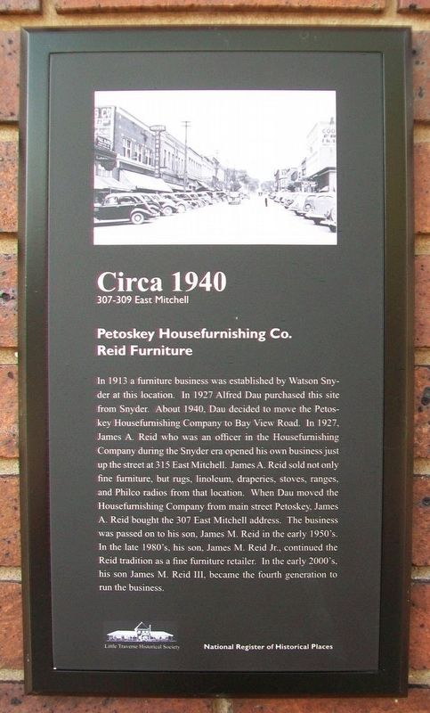 In 1913 a furniture business was established by Watson Snyder at this location. In 1927 Alfred Dau purchased this site from Snyder. About 1940, Dau decided to move the Petoskey Housefurnishing Company to Bay View Road. In . . .
  This location served as the post office for Petoskey from 1918 until 1962 when it was decided that Petoskey needed a new facility due to the growth of the surrounding townships. The post office was razed and the location . . .
  This plaque is issued by the Historical Society of Michigan in recognition of Old Kent Bank of Petoskey Founded in 1891 For more than 100 years of continuous operation in service to the People of Michigan and for . . .
  The Coburn building, constructed in 1892, is home to both the 316 and 318 addresses. The 316 address was originally housed by hardware stores run by a variety of men who partnered with Sydney Bump. His partners were Henry . . .
  The 325 address is no longer in existence. It was absorbed by the First National Bank expansion in 1964. In 1909 George Koulis operated the First Class Ice Cream Shop and Confectionary business on the 325 site. John Laggis . . .
  The Town of Putney Remembers Our Men and Women Who Served To Protect Our Freedoms ? POW † KIA ? MIA ? DIS ? Wounded Dedicated November 9, 2003 (left panels) Revolutionary War Alexander, Aaron • Baldwin, Levi • Black, John • . . .
  Putney Town Hall 1871 is part of the Putney Historic District placed on the National Register Of Historic Places
 Napoleon 12 Pounder Bronze Field Gun Model 1857 Bore: 4.62 ". Tube Weight: 1225 lbs. Tube Length: 66" . Maximum Range: 1660 Yards Ordnance Inspector: T.J.R. 1863 (Thomas Jackson Rodman, Union Officer) U.S. Stamped (Tested . . .
  Las acrópolis son construcciones masivas, formadas por una serie de edificios colocados uno sobre otro a través de muchos años. Estas eran utilizadas por los gobernantes como residencias y lugares administrativos, su acceso . . .


