Quantcast
Channel: The Historical Marker Database - New Entries
Viewing all 103809 articles
Browse latest View live

Germania Mill: Recovering from the Civil War

$
0
0
Fredericksburg, Virginia.
In front of you stood the Germania Mill, built in 1866 by Myer and Frederick Brulle. Both men were immigrant German confectioners who teamed up after the Civil War to became millers.

Fredericksburg’s upper canal powered this enterprise and Germania Mills Brand Flour was shipped as far as New York, Philadelphia, Baltimore, Richmond, and South America.

Business flourished well into the twentieth century and the concrete grain elevator was added in 1917. The days of water powered milling, however, were ending. More cost effective processing elsewhere relegated this once bust industrial building to use as a storage facility. A fire reduced it to a ruin in 1980 and it was fully demolished in 2010.

(sidebar)
Germania Mill, Inc
Manufacturers of High Class Brands of Flour and Meal From Choice Wheat and Corn
Choice Superlative and XXXXX
Extra Germania Flour, Family, Meal, All Water Ground.

—(Advertisement from The Daily Star, Fe, 28, 1917)

(captions)
This 1968 photo shows the old Germania Mill still intact on Caroline Street. In the foreground is the one story City Electric Light Works (inactive since 1919) and in front of that, the stone lined tailrace of the Washington Woolen Mills. (Image courtesy of the Virginia Department of Historic Resources)

This drawing by Gustavus Erickson depicts an 1876 fire that destroyed much of the original mill. Myer and Brulle quickly rebuilt and remained in operation for several more decades. (Image courtesy of the Fredericksburg Area Museum and Cultural Center)

(Industry & Commerce • War, US Civil • Man-Made Features • Waterways & Vessels) Includes location, directions, 2 photos, GPS coordinates, map.

Hydroelectricity Brings Changes to Fredericksburg

$
0
0
Fredericksburg, Virginia.
Desperate for economic growth, following the Civil War, Fredericksburg embraced the technological innovation of hydroelectricity. In 1887, a local firm converted an old grist mill near the Falmouth Bridge to an electric generating plant. In 1901, the local government built its own hydroelectric facility, calling it the City Electric Light Works.

The municipal power plant remained in operation until 1919. lts output, however, was direct current (DC), which has a limited range. The more substantial Embrey Power Station, constructed in 1910, generated alternating current (AC), which can be transmitted greater distances. It provided electric power well beyond the city limits.

Electrification had a profound impact on the area’s industrial development. Factories could be removed from places susceptible to river flooding and built closet to rail connections and roadways. The Embrey Plant closed in the 1960s, when a nuclear plant became operational on the North Anna River.

(captions)
Capt. McCracken, Chairman of the Light Committee, reported three bids for the erection and installation of an Electric Light Plant for lighting the streets of the city (City Council meeting of June 15, 1900).

The transition from hydromechanical power to hydroelectricity is evident in this 1909 photo of the concrete Embry Dam being constructed across the Rappahannock River. The Fredericksburg Water Power Company’s stone and timber dam, which can be seen just upstream, would be covered by the new reservoir.

The City Electric Light Works, whose wheel pit is visible in front of you, powered city lights for 18 years. The Embry Power Station, to your left front, remained operational for 50 years. (Image courtesy of Virginia Department of Historic Resources)

In 2004, the U.S. Army Corps of Engineers demolished the 1910 Embry Dam and the 1854 Fredericksburg Water Power Co. dam. Removal of this industrial infrastructure provides significant environmental benefits to Virginia fisheries.

(Industry & Commerce • Man-Made Features • Waterways & Vessels) Includes location, directions, 2 photos, GPS coordinates, map.

Rappahannock River Heritage Trail

$
0
0
Fredericksburg, Virginia.
(side 1)
Fredericksburg’s Lower Canal
The falls of the Rappahannock River powered local industries for more than two centuries. Francis Thornton established the first grist mill around 1720. By 1770, James Hunter operated an iron forge complex in Stafford. The Falmouth Canal (c.1800) fed additional Stafford industries and an extension of the raceway at Thornton's Mill also served newer industries. Water power helped Fredericksburg recover from the devastation of the Civil War and even attracted hydroelectric production as early as 1887. In time, electrification allowed plants to be built away from the river, which often flooded. After a new hydroelectric plant opened in 1910, fed by Fredericksburg's upper canal, this lower canal fell into disuse.

Map legend:
1. Hunter's lron Works, c. 1770-1862
2. Falmouth mills, c. 179O-c. 1880
3. Lawrence's Mill, 1806
4. Diversion dam to feed lower canal, 1887/1907
5. Stone bridge abutment
6. Concrete control gates, 1907
7. Thornton's Mill, c. 1720
8. Knox Mill, (became Rappahannock Electric Light & Power Co. in 1887)
9. Bridgewater Mill (Ficklen's Mill), 1822-1912
10. Fredericksburg Wood Working Plant (Knox), 1896-1904
11. Hollingsworth Mill (later Knox)

(captions)
This 1856 lithograph shows the lower canal as well as several mills. (Courtesy of James Monroe Museum and Memorial Library)

These concrete control gates (site #6 on the map) were constructed in 1907 to improve Fredericksburg’s lower canal. Though sometimes obscured by nature, the remnants of water-powered industries can still be found.

The Bridgewater Mill (once called Ficklen’s Mill) is site #9 on the map. The surviving stone foundations are extensive.

(side 2)
Fredericksburg's Upper Canal
Fredericksburg’s upper canal was initially part of the Rappahannock Navigation system. Construction began in 1829 and a navigable system of dams and canals that bypassed the river's rapids had reached 50 miles upstream by 1849. Canal boats carried agricultural goods and timber downstream and moved supplies and equipment upstream for a thriving gold mining industry. New railways, however, cut into the navigation company's markets and gold strikes in California drew mining activity to the West. In 1854-55, the Fredericksburg Water Power Company acquired this under-used canal and converted it to a raceway. As a power canal, it remained in use into the 1960s, feeding the turbines of the Embrey Power Station to produce hydroelectricity.

Map legend:
A. Site of Fredericksburg Water Power Co. Dam (1855/1889) and Embrey Dam (1910)
B. Stone bridge abutment
C. Stone bridge abutment
D. Holding pond (for municipal water treatment plant—demolished)
E. Paper mill site
F. Canal turning basin
G. Shepherd's Mill
H. Germania Mills (Myer & Brulle), 1866/concrete grain elevator, 1917
I. Municipal Electric Generating Plant, 1901-1919
J. Washington Woolen Mills, 1859-1910
K. Embrey Power Station, 1910-c. 1962
L. Klotz Throwing Co. (Virginia Silk Mills), 1889-1934

(captions)
This 1856 lithograph shows the lower canal as well as several mills. (Courtesy of James Monroe Museum and Memorial Library)

The once prominent Klotz Throwing Company (also known as the Virginia Silk Mills) is site “L” on the map. Though reduced to a single story structure, some of its architectural features remain evident.

(Industry & Commerce • Man-Made Features • Waterways & Vessels) Includes location, directions, 3 photos, GPS coordinates, map.

Confederate and Federal Defenses in May 1863

$
0
0
Fredericksburg, Virginia.
Heavy fighting erupted in this area on May 3rd and 4th, during the Chancellorsville campaign. On May 3rd, Brigadier General Cadmus M. Wilcox moved several Alabama regiments into the area (1) and confronted Federal forces at this canal (2). When the Union Sixth Corps broke through at Sunken Road (3), most of the Confederates retreated down the Telegraph Road, now called Lafayette Boulevard (4). Wilcox, however, chose to delay the Federals as they advanced out of Fredericksburg (5). The Sixth Corps pushed west as Wilcox fell back (6). Confederate reinforcements bolstered Wilcox at Salem Church, where they battled the Federal advance to a halt (7). The Northerners pulled back to a defensive position, which included these hills previously held by the Alabamians.

On the morning of May 4th, the Confederates moved back up Telegraph Road (Lafayette Boulevard) and regained the heights behind Fredericksburg (8). The Federals in town were effectively cut off from the Union force that had moved west (9). Reinforced Confederates attacked the Federals late in the afternoon, collapsing one line, but then running up against a brigade of Vermont regiments, which held at second line at Smith Run (10). Brigadier General John B. Gordon worked his Georgia brigade into this area and advanced up the ravine to your left front, which threatened the Federal flank (11). The Vermont men withdrew and established a new line along Fall Hill Road (12). During the night, the Sixth Corps withdrew across the river (13).

(captions)
Major General John Sedgwick commanded the Union Sixth Corps, which fought the second battle of Fredericksburg. He would be killed at Spotsylvania Court House in the spring of 1864.

Brigadier General John B. Gordon had been a Georgia Attorney before the Civil War. Despite a lack of military education, he had an aptitude for field command. He led a brigade at the second battle of Fredericksburg.

May 3, 1863.
These maps show modern the road network to help orient this battle action to the ground.

May 4, 1863.

(War, US Civil) Includes location, directions, 2 photos, GPS coordinates, map.

Virginia Central Railway Trail

$
0
0
Fredericksburg, Virginia.
Along the VCR
In 1853, a group of investors incorporated and began to grade a railway route from Fredericksburg to Orange Court House, 37 miles to the west. In Orange, this new railway would connect with a rail line to Gordonsville, Charlottesville, and Lynchburg. By the time of the Civil War, the Fredericksburg & Gordonsville Railroad Company had graded 18 miles of the right-of-way, but had not yet laid any tracks. During the Civil War, the cleared, level railbed proved tactically useful for rapidly moving troops across an otherwise rough landscape. The railway crosses three battlefields, at Fredericksburg, Chancellorsville, and the Wilderness.

Following the Civil War, the South struggled to rebuild its wrecked economy and work eventually resumed on the unfinished railway. By 1873, workers were laying tracks on the previously prepared route and the first train arrived at the Orange station in 1877. By then, new owners of the railway had renamed it the Potomac, Fredericksburg & Piedmont Railroad Company. The tracks were narrow gauge.

The narrow gauge tracks carried trains until 1926, when the Virginia Central Railway acquired and altered them to a standard gauge. This effort to remain competitive did not pay off, though. In 1931, the company abandoned its track to Orange, retaining only one mile of rails near Fredericksburg, which linked 15 industrial customers with the main line Richmond, Fredericksburg & Potomac Railroad. Even this one mile of railway proved difficult to maintain and it too shut down in 1984.

This bicycle/foot trail opened in 2014 and extends nearly three miles to the Idlewood neighborhood. The sounds of train whistles and struggling armies are gone, but historic bridge piers and remnants of Confederate encampments are still visible in the quiet woods.

Captions:
1. This 1884 photograph shows the rail yard in downtown Fredericksburg. The view is looking west.
2. The railway cut is visible on the left side of the photo. The houses on the right are still evident along Lafayette Boulevard. The embankment on the left has been replaced by a residential complex called Cobblestone Square.
3. Virginia Central Railway engine No. 1022.
4. The railway had to cross numerous streams and the original stone abutments were later encased in concrete.
5. The railway company pulled up and sold its tracks after it abandoned the link to Orange Court House. The depressions from the wooden ties are still visible in the foreground.

(Industry & Commerce • War, US Civil • Railroads & Streetcars) Includes location, directions, 3 photos, GPS coordinates, map.

Building a Railroad Through a Stream Valley

$
0
0
Fredericksburg, Virginia.
In the 1850s, work gangs leveled this railway bed by cutting through hills and filling in valleys. They established culverts where the mounded earth would have otherwise blocked streams. To construct such facilities, they first laid down a bed of heavy timbers, which established the proper fall for the water. Two rows of large stones, capped with more stones, then created a solid tunnel through which water could drain.

A substantial culvert in this location stood for more than a century. The upstream end had been reinforced with a stone headwall, which protected it from storms and flooding. The downstream end was not as heavily constructed and eventually collapsed, causing the embankment to start to fall away. A new concrete culvert has allowed the railway bed to be restored.

(captions)
In constructing culverts and bridges along this railway, work crews did not want to haul heavy stones any further than necessary. They quarried their building materials from nearby sources, including the streambed. Note the row of drill marks on the stone in the center. The part of the stone split off from this one was hauled away as construction material.

A stone headwall, once located in the stream valley in front of you, protected this rail embankment from flooding. When the downstream end of the culvert failed, the embankment eroded severely and the entire culvert had to be replaced before this trail could be built.

This 1934 map shows the Virginia Central Railway, then in active use, coursing through the Hazel Run valley and connecting with the Richmond, Fredericksburg & Potomac Railroad, in Fredericksburg. The road labeled as Jefferson Davis Highway is Lafayette Boulevard. The U.S. Route 1 Bypass had not yet been built.

(Railroads & Streetcars) Includes location, directions, 2 photos, GPS coordinates, map.

The Walker Landram House

$
0
0
Fredericksburg, Virginia.
To your left front is a ravine that leads up from Hazel Run to what was once the 230-acre farmstead of Walker Landram. In 1854, he had sold 6.5 acres on the southern edge of his farm to the railway company, where you are now standing. When the Civil War came to Fredericksburg, Landram owned 13 slaves and had become a reasonably prosperous farmer. The 1860 Census valued his land, tools, and slaves at $8,100.

On May 4, 1864, Confederate troops under Brigadier General Ambrose R. Wright deployed across the creek in front of you and advanced through the Landram farm toward Federal forces near the Idlewild mansion. When this battle crashed through his property, Landram’s slaves had already run off and the Confederate army had requisitioned his crops and livestock. The Civil War had reduced him to a subsistence farmer.

(sidebar)
"Gen. Wright advanced as in column through a ravine” —A Confederate soldier

Census Valuation of Landram’s Farm
1860 Census
Land, tools, and slaves: $8,100 1870 Census
Lands and tools: $200

(captions)
This break in the railway embankment was caused by Hazel Run overflowing this bend in its course. The damage came after trains had stopped running.

The Landram Farm complex included the family home, three slave quarters, and other outbuildings. These photos (courtesy of the Fredericksburg Area Museum) show some of the outbuildings as they appeared around 1922. None survive.

On May 4, 1863, the Union Sixth Corps took position between Salem Church and the town of Fredericksburg, its line of communications through Banks Ford (1). A Confederate force held its position at Salem Church (2), where a battle had been fought the day before, while another force retook the heights overlooking Fredericksburg (3). A Confederate probe found the Union line to be held in strength (4), but to the west, the battle of Chancellorsville had been fought to a standstill and the Confederates repositioned troops to concentrate against this isolated Federal corps. A late afternoon attack slammed into the apex of the Federal line (5) and fighting extended to the north (6). The Federals would retreat after nightfall. These maps are oriented to the direction you are facing and also show the modem road network to help relate the action to the ground.

Brigadier General Ambrose R. Wright’s brigade of Georgia troops took position here, with a brigade of Mississippians on their left, under Brigadier General Carnot Posey. These units were the far right of Major General Richard H. Anderson's division. To their right stood Brigadier General Robert Hoke and his brigade of North Carolina troops, constituting the far left of Major General Jubal Early’s division. When the Confederate attack went forward, this seam between the two divisions came apart. Wright took fire from Federal artillery and veered to his left, advancing in the shelter of a ravine, but also losing contact with Hoke. In addition, Wright cut across Posey's front, negating any potential support.

(Agriculture • War, US Civil • Railroads & Streetcars) Includes location, directions, 2 photos, GPS coordinates, map.

Excavation Site: New Boiler Plant and Smoke Stack

$
0
0
Laramie, Wyoming.
Steam was used to heat the new cellblock and administration wing added to the prison in 1889. Though the boiler was only intended to serve the new addition it heated the entire prison (both cellblocks). Working beyond its capacity, the old boiler needed repairs by 1898.
Mr. Cook, a plumber hired by the prison, reported "the boiler now in use was in dangerous condition and was not large enough to heat both wings of the prison and supply hot water for bathing and laundry work ... in its present condition, the boiler could be blown up by a convict in charge and that it was a menace to the safety of the institution.
By September of 1898, plans were made to install a new, 35-horse power, tubular boiler. The new boiler house and smoke stack appears behind the man and bull in the photograph to the left.
Prisoners made bricks for the boiler house and chimney, excavating a foundation for it between the prison and broom factory (the broom factory is seen in the photograph to the right). The inmates also excavated tunnels for the pipes laid to the penitentiary and broom factory. These pipes supplied heat and hot water for bathing and laundry.
New steam radiators were installed to heat the broom factory previously heated by wood and coal stoves. The new boiler plant and installation of pipe and radiators cost $1,975.00.
Both photographs were taken shortly after 1907 when the University of Wyoming operated an experimental stock farm on the prison grounds (inmates were removed from this facility in 1903 and transferred to the Frontier Prison in Rawlins. WY).

(Industry & Commerce) Includes location, directions, 3 photos, GPS coordinates, map.

The Railway, With Tracks and Without

$
0
0
Fredericksburg, Virginia.
In 1877, the Fredericksburg and Gordonsville Rail Road began operations, with narrow gauge tracks connecting to established railways running through Fredericksburg and Orange. A series of companies tried to make this railroad profitable, including a company called the Virginia Central Railway, which upgraded the narrow tracks to the standard gauge in 1926. Still, insufficient traffic caused this part of the railway to be abandoned in 1938.

The surrounding landscape has its own history. During the winter of 1862-63, a Confederate winter encampment covered the hills north of Hazel Run. The Southern troops built small huts on the southern exposure of the nearby slopes. In the spring of 1863, during the Chancellorsville campaign, this cleared and level railway (without tracks) also proved an excellent covered way to rapidly deploy troops across the rough terrain.

(captions)
When the Virginia Central Railway upgraded its tracks from a narrow gauge to a standard gauge, it replaced stone abutments with poured concrete piers, to handle the wider tracks. Note that the end facing upstream is pointed, like the prow of a ship.

A rail link between Fredericksburg and the Town of Orange appeared to be a critical need within Virginia's network of railways, but never proved profitable. The cleared, but unfinished route is more readily remembered as part of a Civil War battlefield.

Hut holes in the woods on the opposite side of Hazel Run are all that remain of a large Civil War encampment. The winter huts were of rude construction and locating them on a southern exposure was an attempt to derive as much comfort as possible from the sun.

On the afternoon of May 4, 1863, Confederate troops moved through this area along the graded route, preparing for an assault against Federal forces along Plank Road (State Route 3).

(Industry & Commerce • War, US Civil • Railroads & Streetcars) Includes location, directions, 2 photos, GPS coordinates, map.

Virginia Central Railway Trail

$
0
0
Fredericksburg, Virginia.
Along the VCR
In 1853, a group of investors incorporated and began to grade a railway route from Fredericksburg to Orange Court House, 37 miles to the west. In Orange, this new railway would connect with a rail line to Gordonsville, Charlottesville, and Lynchburg. By the time of the Civil War, the Fredericksburg & Gordonsville Railroad Company had graded 18 miles of the right-of-way, but had not yet laid any tracks. During the Civil War, the cleared, level railbed proved tactically useful for rapidly moving troops across an otherwise rough landscape. The railway crosses three battlefields, at Fredericksburg, Chancellorsville, and the Wilderness.

Following the Civil War, the South struggled to rebuild its wrecked economy and work eventually resumed on the unfinished railway. By 1873, workers were laying tracks on the previously prepared route and the first train arrived at the Orange station in 1877. By then, new owners of the railway had renamed it the Potomac, Fredericksburg & Piedmont Railroad Company. The tracks were narrow gauge.

The narrow gauge tracks carried trains until 1926, when the Virginia Central Railway acquired and altered them to a standard gauge. This effort to remain competitive did not pay off, though. In 1931, the company abandoned its track to Orange, retaining only one mile of rails near Fredericksburg, which linked 15 industrial customers with the main line Richmond, Fredericksburg & Potomac Railroad. Even this one mile of railway proved difficult to maintain and it too shut down in 1984.

This bicycle/foot trail opened in 2014 and extends nearly three miles to the Idlewood neighborhood. The sounds of train whistles and struggling armies are gone, but historic bridge piers and remnants of Confederate encampments are still visible in the quiet woods.

Captions:
1. This 1884 photograph shows the rail yard in downtown Fredericksburg. The view is looking west.
2. The railway cut is visible on the left side of the photo. The houses on the right are still evident along Lafayette Boulevard. The embankment on the left has been replaced by a residential complex called Cobblestone Square.
3. Virginia Central Railway engine No. 1022.
4. The railway had to cross numerous streams and the original stone abutments were later encased in concrete.
5. The railway company pulled up and sold its tracks after it abandoned the link to Orange Court House. The depressions from the wooden ties are still visible in the foreground.

(Industry & Commerce • War, US Civil • Railroads & Streetcars) Includes location, directions, 2 photos, GPS coordinates, map.

Reestablishing a Travel Way

$
0
0
Fredericksburg, Virginia.
The many culverts along this railway were established during its construction, before the Civil War. Where the land is little altered, these drainage features remain intact and functional. Stormwater flowing off of new roads, rooftops, and parking lots, however, has overwhelmed others and the additional water has invariably cut its own path. In this location the rail embankment eroded away and attempted repairs with concrete were unsuccessful.

When the historic stone culvert became blocked, this small creek established a new channel through this man-made barrier, exposing the old culvert to further damage. During trail construction, work crews placed a new concrete culvert alongside the historic culvert and then backfilled with gravel to cover it up. This work arrested the ongoing damage and stabilized the historic feature.

(captions)
Though increased stormwater from modern development has caused some of the original stone culverts to collapse, many others remain intact along this historic railway. Their natural material blends into the landscape.

During trail construction, workers carefully encapsulated the historic stone culvert. The old rails sticking out of the concrete encasing part of the historic culvert are visible above the red gas can.

An early attempt to encase the old culvert in concrete proved futile. Same old rails were used as reinforcement and are visible across the trail to your right.

When the original culvert became blocked, the persistent power of water forced its way through the rail embankment. Remnants of the stone culvert, since covered over, are visible on the right. View is looking toward Hazel Run.

(Railroads & Streetcars • Man-Made Features) Includes location, directions, 2 photos, GPS coordinates, map.

Excavation Site: Blacksmith Shop, Candle Shop, and Outhouse

$
0
0
Laramie, Wyoming.
The 1907 photograph to the left shows, from left to right, the boiler plant (foreground), broom factory, outhouse, blacksmith and candle shop, and kitchen extension.
Before shops were built inside the stockade, inmates worked outside cutting stone, making bricks, gathering ice from the river, and farming (mostly potatoes).
In 1892, Lessee James Marsh proposed constructing a workshop on the grounds for the betterment of the convicts. He argued, "The health of the convicts demands that some arrangement be made for their employment, particularly during the winter season... steady and moderate employment is absolutely essential to good health of the inmates of the Pen. It is therefore, humane to furnish them a place and a means of occupation." Letter to the Board of Charities & Reform, Sept. 14, 1892
In 1893, Warden N.D. McDonald "requested permission to expend $40 for materials to complete the blacksmith shop and candle factory." As reflected in the December Minutes of the Board of Charities and Reform, the motion was "duly carried."
On June 24, 1878, the Laramie Sentinel reported, "Fonce Raines, the Black Hills Stage robber, now in the penitentiary here for 17 years, made a break to get away this afternoon. He went to the water closet and when he came out, slipped around so as to get out of sight of the Sentry Box, and started off on a run. The guard fired at and shot him through the thigh, bringing him to the ground. The injury is severe, but probably not dangerous, a flesh wound. If he had been killed, nobody in this region would have gone into mourining (sic) for him. Warden House has a lot of guards there whom it is not worth while to fool with."
On May 19, 1896 the Laramie Boomerang reported another escapee, William Dougherty "secured a small drill which he made in the prison blacksmith shop. It was chilled steel." He used it to drill holes through the bars of his cell and escape. He was never recaptured.

(Notable Events) Includes location, directions, 2 photos, GPS coordinates, map.

Excavation Site: Old Kitchen and Bakery Ovens

$
0
0
Laramie, Wyoming.
The original kitchen was constructed in 1873. The bakery ovens sat directly behind it. The extension to the left of the kitchen was added by 1894 and used for a variety of things: store room, icehouse, guards' dining hall, carpentry shop, and bakery.
In 2006, the Wyoming Territorial Prison received a grant from the History Channel and partnered with the University of Wyoming Lab School to excavate the kitchen extension. This project determined the building's use and gave middle school students hands-on archeology training.

When asked, "What do you like best about the prison project?", students answered:
"I like the excavation part. In my opinion, the best way to learn and teach history is to feel it. Hands-on activities like excavation let students understand and comprehend history better than other projects. When reading a textbook you can't hold a fragment of a late 1800s bullet shell in you hand." - Sean Peel.
My favorite part was digging at the site because the class got to learn outside and experience at least a piece of what real archaeology is like. We followed the current digging, sifting, and bagging procedures." Meghan Kent
"I loved screening because even the smallest objects were interesting. Learning about my ancestors and people that came before me was the best thing I could have gotten out of this." - Kathryn Jones
"I really enjoyed the fact that this was official. I got a sense that I was helping to do something that made a difference." - Phillip Pelkey
"I learned how dirt contains very important history." Mike Henry

(Notable Buildings) Includes location, directions, 2 photos, GPS coordinates, map.

Replica of the Statue of Liberty

$
0
0
Russell, Kansas.

With the faith and courage of
their forefathers who made
possible the freedom of these
United States

The Boy Scouts of America

dedicate this copy of the
Statue of Liberty as a pledge
of everlasting fidelity and
loyalty

40th Anniversary Crusade to
strengthen the arm of liberty

(War, Cold • Man-Made Features • Patriots & Patriotism) Includes location, directions, 3 photos, GPS coordinates, map.

Replica of the Statue of Liberty

$
0
0
Hays, Kansas.

With the faith and courage of
their forefathers who made
possible the freedom of these
United States

The Boy Scouts of America

dedicate this replica of the
Statue of Liberty as a pledge
of everlasting fidelity and
loyalty

40th Anniversary Crusade to
Strengthen the Arm of Liberty

(War, Cold • Man-Made Features • Patriots & Patriotism) Includes location, directions, 3 photos, GPS coordinates, map.

Replica of the Statue of Liberty

$
0
0
La Crosse, Kansas.

With the faith and courage of
their forefathers who made
possible the freedom of these
United States

The Boy Scouts of America

dedicate this replica of the
Statue of Liberty as a pledge
of everlasting fidelity and
loyalty

40th Anniversary Crusade to
Strengthen the Arm of Liberty

(War, Cold • Man-Made Features • Patriots & Patriotism) Includes location, directions, 3 photos, GPS coordinates, map.

Replica of the Statue of Liberty

$
0
0
Saint John, Kansas.

With the faith and courage of
their forefathers who made
possible the freedom of these
United States

The Boy Scouts of America

dedicate this copy of the
Statue of Liberty as a pledge
of everlasting fidelity and
loyalty

40th Anniversary Crusade to
strengthen the arm of liberty

(War, Cold • Man-Made Features • Patriots & Patriotism) Includes location, directions, 5 photos, GPS coordinates, map.

Lime Kiln Dam Removal

$
0
0
Grafton, Wisconsin.
Fish Passage Program

Between 2006-2013, the Ozaukee County Planning and Parks Department was awarded over $8.5 million in federal, state, local, and private funding to develop, refine, and implement a comprehensive "Ozaukee Fish Passage Program" (Program). The Program reconnects naturally existing high-quality habitat in the Lake Michigan Basin and Milwaukee River Watershed by modifying or removing impediments to fish and aquatic life passage. The Program seeks to re-establish migratory fish passage between 119,000 acres and 158 stream miles of the Milwaukee River Watershed, the Milwaukee Estuary, and Lake Michigan. Fish and other aquatic life require access to various habitats at different times of the year to reproduce, grow, feed, and survive. Human activities can directly or indirectly create impediments that fragment and inhibit access to high quality habitats. This directly affects species abundance, distribution, genetic diversity, and recreational opportunities. Passage for healthy adults moving upstream and young-of-the-year moving downstream are equally crucial. Impediments such as dams, improperly placed or sized culverts, and channelized tributary streams can prevent fish and aquatic organisms from accessing critical habitats. Wisconsin's native fish, including northern pike, are poor swimmers and jumpers and are often most impacted by impediments. Pike can only jump about eight inches, cannot swim effectively in water velocities greater than two feet per second, and require frequent rest areas when traveling through streams. The Program reconstructs road/stream crossings to replicate natural features of the adjacent stream and establish conditions supporting native fish passage. The Program also works with local municipalities, non-profits, volunteers, landowners, and conservation groups to remove small-scale barriers including log jams, railroad ballast deposits, and invasive vegetation. As of 2013, over 203 impediments have been identified and remediated on the mainstem Milwaukee River and 30 tributary streams, reconnecting over 100 miles of streams and rivers to fish passage. Major projects include construction of a nature-like fishway at the Mequon-Thiensville Dam (Village of Thiensville and City of Mequon), designing a fishway for the Bridge Street Dam (Village of Grafton), removal of the Lime Kiln (Village of Grafton) and Newburg Dams (Village of Newburg), and several large-scale habitat enhancement projects (floodplain and wetland connectivity) on multiple tributary streams (e.g. Mole and Ulao Creeks).

Dam Removal The Lime Kiln Dam was removed by the Ozaukee County Planning and Parks Department and Highway Department in 2010 in cooperation with the Village of Grafton and landowners. The project was funded by an American Recovery and Reinvestment Act (ARRA) grant administered by the National Oceanic and Atmospheric Administration (NOAA) and included removing debris and fill from the former raceway, impoundment dewatering through the raceway, dynamite blasting to fracture the dam face and footing, and concrete and debris removal with heavy equipment. Ozaukee County also completed multiple restoration activities including: bank stabilization, public access amenities, construction of a wooden pedestrian bridge over the old raceway for public access to the exposed bedrock island, invasive vegetation removal, and native prairie seeding and tree plantings. The project restored access to a total of 32 river miles of mainstem habitat in the Milwaukee River from Lake Michigan upstream through the former impoundment. Anticipated results include: improved aquatic life passage, improved fishery and riparian habitat, restored habitat access for threatened and endangered species, increased tourism, improved water quality, kayak/canoe recreational passage, re-established floodplain and enhanced public access for area residents to enjoy the local natural resources. The dam's removal yielded timely benefits to restoration efforts for endangered species, providing passage for mature lake sturgeon to spawn on high quality, exposed bedrock and cobble just upstream of the former dam when they return to the Milwaukee River to reproduce. Following dam removal, this stretch of river has become a popular destination for smallmouth bass and salmon anglers.

Target Species
Walleye (Sander vitreus)
Northern Pike (Esox lucius)
Lake Sturgeon (Acipenser fulvescens)
Other species of concern: Striped Shiner, Greater Redhorse, Ellipse Mussel, and Longear Sunfish

The Northern Pike Life Cycle A: Sticky eggs (up to 30,000 per female) are deposited on submerged grassy vegetation in creeks, wetlands, and road-side ditches keeping the eggs out of the sediment. Male northern pike then release milt to fertilize eggs.
B: In about two weeks, the sticky eggs turn into yolk sac larvae, which are only 8 mm long and swim for about one day.
C: The yolk sac larvae reattach to vegetation for the four or five days it takes to absorb the yolk sac.
D: Free-swimming northern pike larvae break free from vegetation and stay in warm shallow water, soon feeding on insects and other fish.
E: Northern pike grow quickly and move to larger waterbodies. One year old males (12-16") and two year old females (18-20") are ready to spawn.
F: In late March and early April, mature adults travel up streams and ditches to spawn in shallow, flooded marshy floodplain and wetland areas, returning to areas where they were born or have previously spawned.

Northern Pike Swimming Performance
-Good for short distance "bursts" of less than 15 seconds
-Fair for "sustained" movements in velocities of less than two feet per second
-Poor for "prolonged" swimming
-Poor jumpers
-Short jumps of less than eight inches
-Require frequent rest areas

Funding Source
Ozaukee County - NOAA/ARRA Grant $209,000

(Waterways & Vessels • Animals) Includes location, directions, 4 photos, GPS coordinates, map.

Grafton Lime Kilns

$
0
0
Grafton, Wisconsin.

Lime Kilns
This park was once part of a limestone quarry operated by the Milwaukee Falls Lime Company, incorporated in 1890. Five vertical kilns were built for burning limestone from the quarry on the site to make quicklime. The kilns were built of stone lined with firebrick. The fasteners on the timbers are nuts threaded onto long steel rods through the structures to reinforce them.

The kilns were fueled with cordwood, creating temperatures from 1,400 to 2,000 degrees Fahrenheit, converting calcium carbonate to calcium oxide or lime, which when mixed with water, was widely used in construction and for tanning hides.

Mules pulled the trams of limestone from the quarries to the crusher, and then cables pulled them on tracks atop the kilns, which were stoked with cordwood in the fireboxes below. When the limestone was dehydrated, it was pounded into a fine powder which was used for plaster, mortar, fertilizer, and white wash. A spur line carried the processed lime to the main line of the old Wisconsin Central Railway for shipments to Milwaukee, Chicago, St. Louis and Detroit. By the spring of 1901, the Milwaukee Falls Lime Co. employed 50 men and shipped 5 to 6 train car loads of lime per day. The kilns stopped operating in the 1920's.

The three remaining kilns were restored many years ago, and serve as monumental reminders of Grafton's industrial activity and related history during the late 19th and early 20th centuries.

Iron Bridge
In 1888, this iron bridge was built across the Milwaukee River at Bridge Street to replace the original wooden one, maintaining the only access to the village from the east. Built by the Wisconsin Bridge and Iron Co. of Wauwatosa, the old iron bridge was the main entrance into the Village for many years. This riveted iron bridge was the only way across the Milwaukee River in the Village of Grafton until 1928 when the new concrete bridge on Washington St. was built to handle increased car and truck traffic.

The bridge is an iron truss bridge comprised of seven modules - a triangular module on each end and five rectangular modules in between with diagonal tension rods in all five. The riveted assembly has a cast iron sign at the top reading "1888 BUILDERS WISCONSIN BRIDGE & IRON CO. WAUWATOSA WIS." The deck is made of heavy wooden planks and was single lane to accommodate horse-drawn wagons. Tension rods run along each side below the deck level. The entire bridge was coated with aluminum paint after being moved from its original location on Bridge Street over the Milwaukee River.

The bridge was moved to the Lime Kiln Park in 1996, when the bridge was replaced by a concrete one. It is one of the few remaining steel truss bridges in Wisconsin.

(Industry & Commerce • Bridges & Viaducts) Includes location, directions, 6 photos, GPS coordinates, map.

Propeller from the S.S. Badger

$
0
0
Port Washington, Wisconsin.
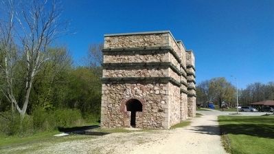
This 13'8" propeller, weighing 7 tons, is from the S.S. BADGER, which was built by the Christy Corporation of Sturgeon Bay, Wisconsin and launched in 1952. The SPARTAN, a twin of the BADGER was built at the same time. The two carferries bear the mascot names of the University of Wisconsin and the University of Michigan State.

The S.S. BADGER is the last coal fired steam carferry operating on the Great Lakes. She is 410'6" in length; has a beam of 59'6" and a draft of 18'6". As currently configured, she can carry 620 passengers, 180 autos and a crew of 50 to 60. She has a cruising speed of 18 MPH. The BADGER runs between Manitowoc, WI and Ludington, MI seasonally. This Propeller was donated to the Port Washington Marina By Robert Manglitz, CEO and President of the Lake Michigan Carferry Service. It stands in tribute to the hundreds of commercial freighters that once called at Port Washington.

Contributors to the Development of this Display
Linda M. Nenn and Richard D. Smith, Facilitated the donation
Bay Ship Building, Sturgeon Bay, WI
Great Lakes Boat Transport, Port Washington, WI
Modern Equipment Co., Port Washington, WI
Dennis Didier, Fabrication, Port Washington, WI
Schmitz Ready Mix, Port Washington, WI

The Cost of Propeller Take Off in 1956 was $100,000.00
Dennis L. Chreny, Harbor Master 2007

(Waterways & Vessels) Includes location, directions, 3 photos, GPS coordinates, map.

Viewing all 103809 articles
Browse latest View live


Latest Images