, Dominica.![]()
3000 BC - The first Amerindian people settle in the bay.
Les premiers Amérindiens s'installent dans la baie.
1493 - One ship of Columbus fleet on his 2nd Voyage enters the bay and sees dwellings and people.
Un navire de la flotte de Christophe Colomb entre dans la baie lores de son deuxième voyage et remarque la presence d'habitations et d'un peuplement.
1504 - Christopher Columbus passes the Cabrits on his 4th Voyage.
Christophe Colomb passe devant les Cabrits lors de son quatrième voyage.
1535 - The Spanish Council of the Indies declares this bay as a station for its treasure ships.
Le Conseil Espagnol des Indes Occidentales déclare cette baie comme une station pour ses navires transportant des trésors.
1565 - Sir John Hawkins, Sir Francis Drake, Sir Richard Grenville and other privateers and pirates being to use the bay to refresh their ships and trade with the Kalinago/Caribs.
Sir John Hawkins, Sir Francis Drake, Sir Richard Grenville et autres corsaires et pirates commencent à utiliser la baie comme un centre de ravitaillement et commerce avec les Caraibes/Kalinago.
1652 - Prince Rupert of the Rhine, cousin of King Charles I, uses the bay for repair and shelter. The bay is named after him.
Le Prince Rupert de Rhine, cousin du roi Charles 1
er, utilise la baie comme un radoub et un abri. La baie est nommée après lui.
1763 - Dominica is ceded to Britain by the Treaty of Paris.
La Dominique est cédée a la Grande Brétagne par le traité de Paris.
1765 - First small gun battery erected on this site.
Première artillerie légère érigée sur le site.
1774 - Major construction of Fort Shirley and Cabrits Garrison begins with a workforce of 400 enslaved Africans.
Début des travaux de construction d´une partie importante de Fort Shirley et de la garnison des Cabrits avec une main d´oeuvre de 400 esclaves africains.
1778 - French forces capture Roseau. This garrison surrenders. Building work continues under the French.
Les Forces Francaises capturent Roseau. Cette garnison se rend mais la construction continue.
1782 - Battle of the Saints fought off of the Cabrits on 12th April. The British are victorious.
La bataille des Saintes au large des Cabrits le 12 Avril. Les Britanniques sont victorieux.
1783 - Dominica returned to Britain by the Treaty of Versailles.
La Dominique est rétrocédée a la Grande Brétagne par le Traité de Versailles.
1795 - French republican revolutionaries invade the north coast but are repelled by troops from the Cabrits.
Les Révolutionnaires et républicains francais envaihissent la cote nord de la Dominique, mais ils sont repoussés par les troupes basées aux Cabrits.
1796 - West India Regiments, "The Black Regiments" formed and stationd at Cabrits.
Les régiments des Indes occidentales, "Les Régiments Noirs" sont formés et stationnés aux Cabrits.
1802 - The revolt of the 8th West India Regiment at the Cabrits.
La révolte du 8e Régiment des Indes occidentales éclate aux Cabrits.
1805 - Cabrits Garrison refuses to surrender to the French under General La Grange.
La Garnison des Cabrits refuse de se rendre aux Francais sous les orders du Généra La Grange.
1854 - Fort Shirley and the Cabrits are abandoned by the army. The forest takes over.
Fort Shirley et les Cabrits sont abandonnés par L'armée. La foret envahit le site.
1982 - Restoration of Fort Shirley begins.
Début des travaux de restauration de Fort Shirley.
1986 - The Cabrits Point is declared a National Park.
La Pointe Cabrits est déclaré Parc National.
View of Cabrits Garrison 1799
All walls were white washed and roofs were of red tiles.
(Colonial Era • Forts, Castles) Includes location, directions, 2 photos, GPS coordinates, map.
 Built circa 1820 by Zenon Ledoux family. Excellent example of a Creole raised plantation house. Ovide LaCour owned this house and the nearby LaCour Store. Entered into the National Register of Historic Places in 1979


 This carousel was purchased from Wally Scott, Elk River, Minnesota. He had it set up in the loft of his old barn. It was disassembled and moved to Schnepf Farms in 1999. It took three months to refurbish. This carousel is listed on the National Registry of Historic carousels.
 This historic water tower for Producers Cotton Gin was first erected in 1952 on the corner of Ellsworth and Cloud Roads in Queen Creek. The landmark in Queen Creek was getting ready to be torn down but was quickly moved to Schnepf Farms in 1999 to preserve its history.
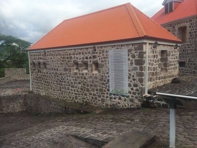
 Opened as a resort on October 29, 1905, Moana Springs took its name from a famous Hawaiian spa. In addition to a large bath house with a pool fed by hot springs, Moana had a stately hotel, a clubhouse, baseball diamond and picnic grounds. Constructed and initially operated by Charles T. Short, (who gave the resort its name), Al North and John N. Evans, Moana was acquired by Louis W . Berrum in 1913 and remained in his family for the next four decades. Served by Berrum's Nevada Interurban Trolley Line from 1907 to 1920, Moana hosted dances, rodeos, boxing matches, trapshoots, circuses and aviation exhibitions. The city of Reno purchased Moana in 1956 and the remaining buildings were demolished the next year to make way for a new recreational complex.
 Before the arrival, 1858, of Granville W. Huffaker driving 500 head of cattle into the Truckee Meadows, the principal settlers were Mormon. The Comstock Lode and its mining needs focused attention on the valley. Huffaker established his ranch in 1859. Langton's Stage Line and the first Post Office were functioning by 1862. For ten years Huffaker's was a most active stage-stop and a center for a community. The school house was constructed in 1868. Bachelors of a jolly nature gathered here for dancing, horse-racing and "land squabbles". The Athenian Literary Society flourished for the more cultured. In 1875 the "Bonanza Kings" completed their Pacific Lumber and Flume operation from the Lake Tahoe Basin. For fifteen miles trestled logs were propelled "by waters rushing faster than any train." At the terminus of the flume, the Virginia and Truckee Railroad opened a depot and telegraph office and constructed a spur where workers transferred timbers.
 Located on the mountain above are the remnants of the "Great Incline of the Sierra Nevada." Completed in 1880, this 4,000 foot long lift was constructed by the Sierra Nevada Wood and Lumber Company. A unique steam-powered cable railway carried cordwood and lumber up 1,800 feet to a V flume which carried the lumber down to Washoe Valley where it was loaded on wagons for use in the mines of the Comstock. Driven by an engine on the summit, 8,000 continuous feet of wire cable, wrapped around massive bull wheels pulled canted cars up a double track tramline. This engineering feat would transport up to 300 cords a day from the mill located in what is now Mill Creek.
 The Laupahoehoe we see now is very different from the Laupahoehoe of old. Laupahoehoe Point was a peaceful, Hawaian fishing village, untouched by missionaries and plantation life; the valley and the sea provided bountiful life. In the late 1800's one of the island's many sugar plantations was located there. Laupahoehoe was one of four deep harbor ports besides Hilo. Ships moored here to transport goods. Tourists braved the seas and skiffs to be unloaded here, just as they did with cattle, sugar, and other merchandise.
 The Civilian Conservation Corps (CCC), established by President Franklin Delano Roosevelt in 1933, was one of many "New Deal" Programs created towards economic recovery from the Great Depression. The goal of the CCC was to create Conservation Jobs for the thousands of young men struggling with unemployment.
 This arch was originally erected on Virginia Street at Commercial Row in 1926 to promote an exposition that celebrated the completion of the Lincoln and Victory highways. Electric bulbs spelled our "Reno" and "Nevada's Transcontinental Highways Exposition, June 25 - Aug 1 1927." Following the event a contest was held by the City Council to find a slogan for the arch. In 1929 a Sacramento man won $100 for his entry, "Reno, the biggest little city in the world." By 1934 some citizens felt that the slogan was passé, so it was eliminated and replaced with "Reno" in green neon. The change was not well accepted. In 1935 the slogan returned with redesigned neon lettering. The arch remained there unaltered until 1963 when it was replaced by a new one. The old arch first moved to the original site of the exposition, Idlewild Park and then to Paradise Park. In 1988, due to its badly deteriorated base, officials placed it in storage.
 The Galena Creek Fish Hatchery represents an attempt to make amends after Nevada's Comstock Lode ravaged the region's ecosystem in the 1860s and 70s. Fishing decimated local streams and lakes to feed a growing population. Eventually, restocking became an important goal.
 Upon entering the Truckee Meadows along the Truckee River, thousands of California-bound emigrants turned their wagons southwest to avoid extensive marshes and uncrossable sloughs. Here at the base of Rattlesnake Mountain the emigrants established a campground, which extended nearly two miles to the east and west, one half mile north and south. Numerous local springs furnished quality water and the protected location of the camp provided an ideal locale for a rest stop after hundreds of grueling miles spent traversing the Humboldt River Valley. Once rested the emigrants turned west to face their last major obstacle, the Sierra Nevada.
 Emigrants including Donner Party camped in this area to rest and refresh their stock.
 In 1853 James Otterson built a hotel near this corner. It was the first building in what would become Mayfield, later a part of Palo Alto. Travelers between San Francisco and San Jose stayed here, as did lumbermen coming from the hills to the bay.
 Side A


