Newark, Delaware.![]()
James Boulden the Elder and his family moved to Delaware from Maryland in the mid-18th century, amassing wealth and expanding their land ownership in Pencader Hundred as the century progressed. The two-story brick mansion house was built during this time period and is a strong representation of Georgian architecture. A service wing erected between 1800-1820 was added to the main structure and is a rare example of stone construction in this area. Five outbuildings situated on the property include a corncrib/granary, a smoke house, a dairy barn and stable, a milk house, and an open frame shed for cattle. In the 1820s, son James ran a diversified farming operation; growing corn, wheat and hay; raising cattle for beef and dairy; using houses and oxen to work the fields; and producing wool from sheep. During the 19th century the farm increasingly focused on dairying, producing milk and butter for the Mid-Atlantic urban markets. After son James' passing in 1826, the farm was left to his grate-nephew and namesake. Circa 1850, James Boulden III carried out substantial renovations to the mansion house incorporating several "Revival" styles, evident in the ornate woodwork and a reorganization of the interior space. The farm remained in the hands of the Boulden family and their descendants until 1918, when the sale of the property ended their 175-year ownership. The architectural and agricultural importance of Poplar Hall was recognized when the property was named to the National Register of Historic Places on January 26, 1988.
(Agriculture • Architecture) Includes location, directions, 5 photos, GPS coordinates, map.
 Near here to the east are ruins of an aqueduct which carried the canal across the Chenango River.
 Historic building was inn of canal travelers 1846-56. Canal boat repair station was east of road.
 West 1/2 mile is the Couch cabin. When Spencer County, State of Franklin, became Hawkins County, North Carolina, the cabin was moved across the road (1786 state line) south from its location on Little Gap Creek (west 200 yards). In 1796 the State of Tennessee was created from this part of The Territory of the United States South of the River Ohio.
 An Indian princess lived in this house.
 First hotel in Greene erected on this site in 1803 by Thomas Wattles
 Across the Chenango River was built on this site in 1807. Susquehanna and Bath Turnpike crossed here.
 First Baptist Church in Chenango County organized on this site by Elder Nathaniel Kellogg in 1795
 Governor of Indiana, 1825 ~ 1831. Erected this house circa 1821 ~ 1822. Palladian window and transom fan~light considered "too aristocratic" by early Hoosiers.
 Built by John D. Howland circa 1856~1857. Later owned and occupied by John H. Farquhar, Merchant, Member of Congress; Aaron C. Miller, Merchant; John C. Hitt, Banker; Dr. John R. Goodwin, Banker, Civil War Surgeon, Paymaster in the Department of the Interior, Trustee of DePauw University; his son Charles F. Goodwin Banker and Trustee o DePauw University; and his grandson John P. Goodwin, banker and long~time member of the Indiana Library and historical Board. In possession of the Goodwin family 1872~1944.
 First tavern in the town of erected on this site by Conrad Sharp, 1794. First town meeting held here in 1798.
 Village laid out in 1806 by Elisha Smith. Was first called Hornby, later named for Gen. Nathaniel Greene. Incorporated 1842.
 The Baptist Society was organized on this site by Elder Nathaniel Kellogg in 1795
 James Boulden the Elder and his family moved to Delaware from Maryland in the mid-18th century, amassing wealth and expanding their land ownership in Pencader Hundred as the century progressed. The two-story brick mansion house was built during this time period and is a strong representation of Georgian architecture. A service wing erected between 1800-1820 was added to the main structure and is a rare example of stone construction in this area. Five outbuildings situated on the property include a corncrib/granary, a smoke house, a dairy barn and stable, a milk house, and an open frame shed for cattle. In the 1820s, son James ran a diversified farming operation; growing corn, wheat and hay; raising cattle for beef and dairy; using houses and oxen to work the fields; and producing wool from sheep. During the 19th century the farm increasingly focused on dairying, producing milk and butter for the Mid-Atlantic urban markets. After son James' passing in 1826, the farm was left to his grate-nephew and namesake. Circa 1850, James Boulden III carried out substantial renovations to the mansion house incorporating several "Revival" styles, evident in the ornate woodwork and a reorganization of the interior space. The farm remained in the hands of the Boulden family and their descendants until 1918, when the sale of the property ended their 175-year ownership. The architectural and agricultural importance of Poplar Hall was recognized when the property was named to the National Register of Historic Places on January 26, 1988.
 The Confederate Circle in Athens City Cemetery contains graves of over 50 soldiers killed in or around Athens during the WBTS, 8 unknown. Around 1898 ladies of the local UDC were working in the cemetery when bones, believed to be soldiers, were found. The ladies felt these soldiers deserved a proper burial. In 1901 the local UDC chapter placed markers with initials of the soldiers on each grave. In 1994 the Chapter researched and ordered new markers with full names and Military Service. The markers were replaced with joint effort of the SCV Camp 768 and UDC Chapter 198
 Chartered on June 24, 1765 by the Grand Lodge of Pennsylvania A.Y.M., Lodge No. 5 at Cantwell's Bridge (later known as Odessa) became the first Masonic lodge established in Delaware. The lodge was admitted to membership under the Grand Lodge of Delaware in January, 1816. Lodge No. 5 moved to Middletown in 1822 and adopted the name "Union" in 1851. With uninterrupted service to the community, Union Lodge No. 5, Ancient Free & Accepted Masons, is distinguished as one of the oldest continuous organizations in the state of Delaware.
 On September 14, 1940, the Lodwick School of Aeronautics began flight instruction in Lakeland by contract with the United States Army Air Corps. Owned and operated by Albert Irvin Lodwick, the school had an initial enrollment of 40 cadets, a peak enrollment of 300, and almost 500 civilian employees. An outgrowth of one of the nine original schools in the AAC pilot training program, the Lodwick School of Aeronautics was the first primary school to open in the Eastern Flying Training Command and one of the last to close. When the school closed August 7, 1945, it had graduated over 6,000 American and 1,200 British pilots.
 The shore of Lake Hancock was home to this region's first settlers. In 1949, Al and Betty Bellotto bought a portion of this property and founded the Cattle B Bar Ranch. Their success in the citrus and cattle industries and desire to conserve open spaces expanded the ranch to more than 1200 acres. In 1994, the citizens of Polk County, recognizing the need to protect natural areas, funded the Polk County Environmental Lands Program. With support from the Southwest Florida Management District this property was purchased from the Bellotto Family in 2000 as a key to the enhancement and protection of the Upper Peace River Watershed.
 El Cerrito was once a town of farms and dairies. The mild weather, lush fields, and many creeks coming down from the hills made for excellent dairy farming. Over the years, there have been about 25 dairies located in El Cerrito.
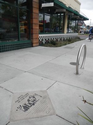 Arts and culture have always been a part of El Cerrito. The City's Arts and Culture Commission, the El Cerrito Arts Association, and many businesses and organizations throughout the City work to engage, promote and celebrate El Cerrito's thriving arts and cultural community.
 This attractive building, El Cerrito's first City Hall, was built in 1926 and replaced in 1961. It housed the City offices, both Fire and Police Departments, and even a small jail. The Council Chambers/Public Hall was upstairs, as was an apartment where the Fire Chief lived.


