near Welaka, Florida.![]() (panel 1)
Mount Royal
(panel 1)
Mount Royal
Mount Royal is an ancient American Indian site that includes the burial mound beyond this display, as well a the remains of a Spanish mission and associated village. The mound was built around 1,000 years ago by the Freshwater Timucua or their ancestors. Members of this same group populated the Spanish mission called San Antonio de Anacape beginning in the late sixteenth century.
Mount Royal has attracted the attention of scientists and visitors to this area for hundreds of years. The rest of this display tells the story of Mount Royal based on the observations and studies conducted by some of these notable people, including naturalist William Bertram, antiquarian Clarence B. Moore, and archaeologist B. Calvin Jones.
I will say that Mount Royal is one of the most fascinating places of all the sites I've ever worked. While a lot of sites up and down the St. Johns (River) are on bluffs, some of which had mounds which are gone now. Mount Royal is one of the most unique ones that I've seen. And to me the aura that it gives off from people having lived there is absolutely marvelous. Once you go to Mount Royal, it's something that gets in your blood that never quite leaves you. - B. Calvin Jones, 1998
Please remember as you visit Mount Royal that the mound is the final resting place for many of the Timucua and that the site it considered a sacred space by many people today.
William Bartram: Eighteenth-Century Naturalist at Mount Royal
William Bartram (1739-1823) was a noted naturalist and explorer who traveled extensively in the American Southeast on the eve of the birth of the United States. He spent considerable time in eastern Florida and along the St. Johns River where a thriving British colony was developing. Bartram wrote of his observations on natural history, as well as his experiences with American Indians like the Cherokee and Seminole. Bartram visited the Mount Royal site at least twice, once with his father John Bartram in 1766 and again in 1774.
At about fifty yards from the landing place, stands a magnificent Indian mount. About fifteen years ago I visited this place, at which time there were no settlements of white people, but all appeared wild and savage; yet in that uncultivated state, it possessed an almost inexpressible extent of old fields, round about the mount; there was also a large Orange grove, together with Palms and Live Oaks extending from near the mount, along the banks, downwards all of which has since been cleared away to make room for planting ground. But what greatly contributed towards completing the magnificence of the scene was a noble Indian highway, which led from the great mount on a strait line, three quarters of a mile, first through a point or wing of the Orange grove, and continuing thence through an awful forest of Live Oaks, it was terminated by Palms and Laurel Magnolias, on the verge of an oblong artificial lake, which was on the edge of an extensive green level savanna. This grand highway was about fifty yards wide, sank a little below the common level, and the earth thrown up on each side, making a bank of about two feet high.
William Bartram, 1791
William Bartram's observations on the Mount Royal mound and other archaeological sites, along with his information on contemporary American Indian tribes figured prominently in the nineteenth century debate regarding the origins of these mounds.
(panel 2)
Clarence B. Moore: Antiquarian Excavations at Mount Royal
Clarence B. Moore was born into a wealthy Philadelphia family, attended Harvard University and spent his twenties and thirties in the elite social circuit and traveling widely in Europe, the Americas and Africa. In the early 1890s Moore focused his attention on American Indian mound sites of the southeastern United States. He traveled extensively, often via houseboat, and made arrangements to excavate many of the mounds along navigable waterways of the South. At the end of each excavation season he returned to Philadelphia to illustrate and describe his finds, producing 21 large books and several articles. Some archaeologists criticize Moore's approach, which often included the complete excavation of mound sites, others, however, are grateful for his careful maps and artifact illustrations, which preserve information about these sites that would have been lost to looting and mining. Many of the artifacts that Moore collected in Florida are now at the National Museum of the American Indian in Washington, D.C.
Moore excavated at Mount Royal early in his explorations; in April 1893 and again in March and April 1894 he focused on the large mound beyond this display. Moore's excavations uncovered human burials, as well as marine shell implements, polished stone tools and ornaments, shell and pearl beads, pottery, and a number of items made of copper.
Moore's description of the mound:
It's true height from the summit plateau to the base, as shown by measurement at the center of the mound, is 16 feet, the circumference is 555 feet. It is composed of the yellow sand of the surrounding fields, with pockets and local layers of white sand along and above the base. Wherever opened, the sand at the bottom of the mound was found mingled with pieces of charcoal. Beginning at the margin at the base, a layer of sand colored by admixture of powdered hematite ranging from crushed strawberry to brick red in color, covered the entire mound. This layer attained a maximum thickness of 7 feet on the northeastern portion of the summit plateau and adjacent slope.
Clarence Moore, 1894
Most notable among Moore's discoveries at Mount Royal are the artifacts of sheet copper. Moore compared the copper objects found in Florida with those found in other parts of the country, as well as with early French accounts of the Timucua tribe, concluding that the copper artifacts from Mount Royal were made by the ancient American Indians. Archaeologists have more recently recognized that the copper artifacts from Mount Royal are representative of artifacts associated with the "Southern Cult" of Southeastern Ceremonial Complex found at archaeological sites throughout the Southeast during the Mississippian period (around 1,100 to 400 years ago).
B. Calvin Jones: Archaeology of San Antonio de Anacape
B. Calvin Jones worked as an archaeologist for the State of Florida from 1968 until his untimely death in 1998. Jones had a distinguished career, built in part on his uncanny knack at finding significant archaeological sites. In many cases his excavations were designed to salvage information before the bulldozers cleared the way for development.
Spanish mission sites held particular interest for Jones. He located a number of Spanish missions in the area around Tallahassee and had a keen knowledge of mission era artifacts and site types. Jones had the opportunity to test the idea proposed by earlier archaeologists that the Spanish mission of San Antonio de Anacape was located at Mount Royal during the development of Mount Royal Airpark and Mount Royal Estates. Beginning in 1983, with additional work in 1994 and 1995, Jones and a dedicated group of volunteers excavated areas to the south of the mound. Excavations uncovered evidence of an American Indian village occupied before and after European contact. The remains of American Indian houses and European buildings associated with the Spanish mission period were found. The excavations uncovered many artifacts, including American Indian and Spanish pottery fragments, shell and stone tools, charred corn cobs, glass beads, religious medals, iron nails and fittings. Artifacts associated with early mission efforts by the Jesuits in the sixteenth century, and later efforts by Franciscans were found at the site and help corroborate an association with San Antonio de Anacape.
Mount Royal: A Place to Remember
In 1977, Jacksonville dentist C. Paul Wilcox and his wife, Willanelle, purchased the Mount Royal property, building their home there and ultimately creating the Mount Royal Airpark and Mount Royal Estates communities. Dr. Wilcox, recognizing the importance of Mount Royal, offered to donate the mound to the State of Florida in exchange for a parcel that allowed access for the development. The transfer was completed in 1986. Dr. and Mrs. Wilcox took a great interest in the archaeology and history of the site and supported the work conducted by Calvin Jones in the 1980s and 1990s. Mrs. Wilcox often gave impromptu tours to those visiting the mound or excavations.
(Native Americans • Cemeteries & Burial Sites • Anthropology) Includes location, directions, 6 photos, GPS coordinates, map.
 Indians constructed the mound and earthworks of this site between A.D. 1250 and 1500. They built the mound as a place to bury their dead, and it grew in phases.
 (panel 1)
 The Lincoln Lane school is a historic reminder of segregation in Putnam County. Built in 1938 at a cost "not to exceed $600," the one-room schoolhouse served African American children from grades 1 through 6. Compared with white schools operating in the county during the same time, the school year was shorter and text books were second-hand. Moreover, teachers at this school were paid less, and publicly-funded transportation was not provided to studenst. In 1954, the landmark United States Supreme Court decision of Brown v. Board of Education of Topeka found that the "Separate but equal" doctrine, which had been used to justify segregation in public schools since the 1890s, was inherently unequal and unconstitutional. In 1956, title to the school land was conveyed to Charles E. Brush, a prominent local businessman and resident, symbolizing the end of school segregation in Interlachen. The Historical Society of Interlachen, Inc. purchased the land and building in 2013 in recognition of its historic significance.
 Plantation of Louis Allard was purchased by his grandfather, Don Santiago Lorreins in 1770's from estate of Francisco Hery, called Duplanty, builder of the first Cabildo Building in N.O. in 1769. Acquired from Allard in 1845 by J. McDonough —- given to New Orleans in 1850.
 Community est. 1914 by Illinois Central Railroad. Named for James Harahan, RR President, 1906-1911. Village incorporated 1920. City incorporated 1953. Francis William Mayo, first mayor, 1920-1922.
 Though originally centered around the Theater District of New York City, silent film production companies soon discovered New England winters too harsh for year-round filming. In the winter of 1908 cast and crew of the production company Kalem Players boarded a train for Jacksonville, bringing the fledging industry south. Others would soon follow.
 While Jacksonville bustled with the activity of motion picture filming during the years 1908 through 1916, by the early 1920s little of the industry remained in town. However, over on Laura Street in the Springfield section of Jacksonville, brothers Richard, Bruce and Earl Norman continued to produce silent films. After the untimely death of Earl in 1919, Bruce went on to other enterprises, but Richard Norman was to ultimately establish a permanent place in movie history.
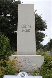 Captain Frederick W. Bruce, for whom Bruce Park is named, was born in New Hampshire in 1856. In 1869 young Bruce was sent to live with his uncle Elisha Bruce in St. Augustine, Florida, but that same year, at age 13, ran away to sea, an adventure that would take him to ports in Cuba, Mexico, and other parts of the Caribbean. After two years Bruce returned to New Hampshire where he studied civil engineering and worked as a sailor during the summers. He also attended navigation school in Boston, Massachusetts, and rose to the rank of captain. He married Clara Paddleford in 1877, and his daughter Louise was born in 1878.
 (side 1)
 The main section of the Battle of Marianna began here at 11 a.m. on September 27, 1864. Confederate cavalry under Col. A.B. Montgomery formed a line of battle across the main street at this point. Union troops, led by Brig. Ben. Alexander Asboth, approached the west. Heavy Confederate fire rolled back the first Union attack, but Asboth ordered a second charge before the Southern troops had time to reload their muzzle-loading carbines and shotguns. Fighting with sabers took place here as the two forces collided. The outnumbered Confederates were compelled to retreat east in the direction of the center of town, still fighting as they went. Union troops followed close behind.
 Located two miles from downtown Jacksonville, south of Craig Creek in San Marco; Oriental Gardens charmed Jacksonville visitors and residents for nearly two decades. In 1925, George W. Clark began planting overflow from his botanical collection on a bluff that he owned overlooking the St. Johns River. This 18-acre private estate was opened to the public in October 1937 and, until 1954, was Jacksonville's major tourist attraction. The Gardens were a popular spot for concerts, picnicking, and photographers, and the majestic live oak trees, hundreds of tropical and subtropical plants, brilliant flowers, arched bridges, and red Chinese gates appeared on countless postcards and souvenirs of Florida. In 1954, the estate was purchased by the State Investment Company and subdivided into 33 single family home sites. Even though the Gardens are gone, their remnants, such as statuary, gate posts, and original stairs to the river, can be seen along Oriental Gardens Road which is now dominated by mid and late 20th century single family homes.
 This 18.5-mile standard-gauge railway was built to carry logs from the large cypress/pine holdings of George W. Hopkins, at Deer Park, to the Union Cypress sawmill just south of Melbourne. Two new and seven used steam locomotives would eventually ride the 50-lb. rails, crossing the St. Johns River on a 2,850-foot wooden trestle south of Lake Sawgrass. This was the first direct route across the St. Johns for 80 miles south of Enterprise, preceding the Kissimmee Highway (U.S. 192) by 6 years. Melbourne to Kissimmee travel was now only 53 miles, compared to a previous 128 miles by rail or 153 miles by road. The railway opened up the vast prairie lands along the St. Johns for settlement and carried much of the regional commerce: cut timber, naval stores, livestock, and farm produce as well as people and the materiel of their daily lives. Trains ferried automobiles across the marsh on flat cars when floods closed the Kissimmee Highway. Logging and railway operations ceased after Hopkins died in January, 1925. Foshee Manufacturing Co. took over in March, 1928, and operated until forced to quit in late 1932 due to a declining lumber market in the Great Depression. Only the skeletal St. Johns River trestle remains today.
 Bethlehem Missionary Church was established March 12, 1825 with twenty charter members and Rev. E.W. Hallway Pastor. Landowners, slaves and the poor were all in the fellowship of the church. In 1826 ten acres of land was bought for $50 to build a church and a public school. The first meeting house was log, and the present wooden building was built in 1858. Bethlehem Church was the first Baptist church in Florida to have a Women's Missionary Society. In 1859 the name was changed to Campbellton Baptist Church and later to First Baptist Church of Campbellton. Full time services began in 1954. The church has been in existence longer than any Baptist church in Florida.
 Union and Confederate troops battled for control of the downtown area as fighting swept east through the streets during the Battle of Marianna. A Union flanking party entered town from the north via Caledonia Street and moved east up Lafayette to form a line of battle at Courthouse Square. Confederate forces under Col. A.B. Montgomery arrived in this area pursued by troops from the Union's 2nd Maine Cavalry and 1st Florida Cavalry (US). Firing took place along this section of Lafayette Street as well as nearby Market Street as the two mounted forces clashed. Hand to hand fighting took place at Courthouse Square as some of the Confederates broke through the flanking party of Union soldiers. Col. A.B. Montgomery, the Confederate commander, was captured on the southeast corner of Courthouse Square.
 The Ays Indians lived along the confluence of the St. Sebastian and the Indian River (Rio d'days) when the Spanish arrived in the 1500s. For hundreds of years after that, settlements in the Indian River area were restricted to the coastal areas where citrus, pineapples, and fishing were the primary industries. In 1816, George Fleming, an Irishman who had served in the army of Spanish Florida, received a large land grant on both sides of the St. Sebastian River. This grant was important in the growth of the area. Roseland's first citizen was Dempsey Cain, who settled on the north side of the river in 1877. Cain is credited with naming the community on the south side of the river Roseland after the wild roses that grew there in abundance. As more settlers arrived, a post office was built in 1892, and in 1893, a depot and water tower were constructed for Henry Flagler's East Coast Railway. In 1910, the A.A. Berry Land Development Company purchased the remnants of the old Fleming land grant. The original Berry Land Office Building still stands in Roseland, as does the 1926 Roseland Community Center, built of lumber salvaged from the first bridge to cross the St. Sebastian River.
 In the summer of 1795, General Wayne and representatives of the Western Confederacy gathered at Fort Greenville in Ohio to negotiate a peace treaty.
 There were multiple noteworthy Americans at the Battle of Fallen Timbers and the Treaty of Greenville. Perhaps you've heard of a few?

 From the book “Connecticut Railroads” by Turner & Jacobs. Train time at Collinsville, Connecticut on the Central New England Railway. Because the main-line track was on the outskirts of town, trains actually backed into the station. This train is sitting along Bridge Street with the bend in the river.


