Oakland, California.
![]() Oakland Canneries
Oakland Canneries
By the early 20th century, harbor improvements, expanded port facilities, and transcontinental rail service had made Oakland one of the state's leading exporters of processed food of all kinds: canned, dried, bottled, and baked. Vegetables, fruits and grains were brought in by rail and truck; processed food was exported by rail and ship. Canneries accounted for much of this activity, providing employment for men and women alike. The foremost canner, California Packing Corporation (CPC), formed in 1916 from a merger of several firms, sold its products under the brand name "Del Monte." The brick structure you see here, angling back to Linden Street, was built by CPC in the early 1920s, incorporating older cannery buildings.
Howard Terminal
The first privately owned cargo facility on the Oakland Estuary, Howard Terminal was established near this spot in 1900, on a 17-acre site at the foot of Filbert Street.
The terminal specialized in bulk commodities like grain, lumber and coal, and it huge coal bunkers loomed over the waterfront for many years. After World War I, when it began handling canned food and other cargoes, the terminal included warehouses and a railway. The site now forms part of the Port of Oakland's Charles P. Howard Container Terminal.
Moore Shipyard
During and after the two world wars, the estuary was one of the busiest shipbuilding ports in the nation. The largest of the local shipyards, Moore Dry Dock (originally Moore & Scott), began operating at the foot of Adeline Street, west of here, in 1909.
The yard produced nearly 60 steel freighters and tankers between 1916 and 1921, setting records for speed of construction and multiple launchings. During World War II, Moore specialized in ship repairs, employing nearly 40,000 workers in an expanded yard covering 128 acres. The shipyard, which also fabricated structural steel for many buildings in the Bay Area, closed in 1961. The site is now occupied by Schnitzer Steel and the Port of Oakland's American President Lines Container Terminal.
(Industry & Commerce • Waterways & Vessels • Architecture) Includes location, directions, 2 photos, GPS coordinates, map.
 Oakland Canneries
 By the early 20th century, harbor improvements, expanded port facilities, and transcontinental rail service had made Oakland one of the state's leading exporters of processed food of all kinds: canned, dried, bottled, and baked. Vegetables, fruits and grains were brought in by rail and truck; processed food was exported by rail and ship. Canneries accounted for much of this activity, providing employment for men and women alike. The foremost canner, California Packing Corporation (CPC), formed in 1916 from a merger of several firms, sold its products under the brand name "Del Monte." The brick structure you see here, angling back to Linden Street, was built by CPC in the early 1920s, incorporating older cannery buildings.
Howard Terminal
The first privately owned cargo facility on the Oakland Estuary, Howard Terminal was established near this spot in 1900, on a 17-acre site at the foot of Filbert Street.
The terminal specialized in bulk commodities like grain, lumber and coal, and it huge coal bunkers loomed over the waterfront for many years. After World War I, when it began handling canned food and other cargoes, the terminal included warehouses and a railway. The site now forms part of the Port of Oakland's Charles P. Howard Container Terminal.
Moore Shipyard
During and after the two world wars, the estuary was one of the busiest shipbuilding ports in the nation. The largest of the local shipyards, Moore Dry Dock (originally Moore & Scott), began operating at the foot of Adeline Street, west of here, in 1909.
The yard produced nearly 60 steel freighters and tankers between 1916 and 1921, setting records for speed of construction and multiple launchings. During World War II, Moore specialized in ship repairs, employing nearly 40,000 workers in an expanded yard covering 128 acres. The shipyard, which also fabricated structural steel for many buildings in the Bay Area, closed in 1961. The site is now occupied by Schnitzer Steel and the Port of Oakland's American President Lines Container Terminal.
(Industry & Commerce • Waterways & Vessels • Architecture) Includes location, directions, 2 photos, GPS coordinates, map.
 Co-Founder of
 Co-Founder of
 Austin Cemetery
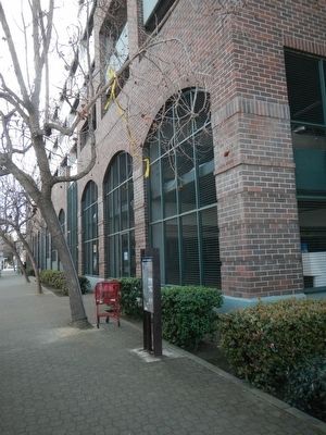 Railroads & Industries
  This was the first house in France to be liberated during the last hour of 5th June 1944 by men of the Oxfordshire & Buckinghamshire Light Infantry in the British 6th Airborne Division under the command of Major R. John Howard.
 En française:
 Emplacement ou Jeanne d'Arc fut brulee le 30 Mai 1431.
 Cimetiere Militaire Allemand 1914-1918
 English version: This tank knocked out in December 44, recalls the sacrifice of all the fighters for the liberation of Bastogne and Belgium.
 To the memory of the soldiers of the United States Army who while prisoners of war were massacred by Nazi troops on this spot on 17 December 1944.
 From mid September 1944 till the end of February 1945 fierce battles raged in the region between the ridge line of the Hautes Fagnes and the Roer River,-a phase of World War II better known as “The Huertgen Forest Campaign”. American soldiers dubbed it “The green Hell of Huertgen” , alternately “The Death Factory”, and during the bitterly cold and snowy winter on 1944/45: “A Hell of Icicles”. Ten thousands of American and German soldiers died during the six months of the fierce and bloody fighting. From mid October to early December 1944 Vossenack lay in the center of the battles. The little town changed hands several times. From time to time, the frontline even ran through the center of the local church.
 From mid September 1944 until the end of February 1945 fierce battles raged in the region between the ridge line of the Hautes Fagnes and the Roer River,-a phase of World War II better known as “The Huertgen Forest Campaign”. American soldiers dubbed it “The green Hell of Huertgen” , alternately “The Death Factory”, and during the bitterly cold and snowy winter on 1944/45: “A Hell of Icicles”.
Ten thousands of American and German soldiers died during the six months of the fierce and bloody fighting. From mid October to early December 1944 Vossenack lay in the center of the battles. The little town changed hands several times. From time to time, the frontline even ran through the center of the local church.
From mid September 1944 until the end of February 1945 fierce battles raged in the region between the ridge line of the Hautes Fagnes and the Roer River,-a phase of World War II better known as “The Huertgen Forest Campaign”. American soldiers dubbed it “The green Hell of Huertgen” , alternately “The Death Factory”, and during the bitterly cold and snowy winter on 1944/45: “A Hell of Icicles”.
Ten thousands of American and German soldiers died during the six months of the fierce and bloody fighting. From mid October to early December 1944 Vossenack lay in the center of the battles. The little town changed hands several times. From time to time, the frontline even ran through the center of the local church. English-Tower 12 Century, Residence Neo-Gothic Middle of 19th Century.
 The Huge wooden cross in the cemetery, replaced the rude one erected on that day in May, 1876, when Father Pierre Boucher led his pilgrimage of Catholic & Protestant marchers back to Jefferson, after an eleven mile trek seeking Divine Intervention in the grasshopper plague. It was the third cross erected that miraculous day. The grasshoppers left.
 The vicinity of Jefferson, even before the organization of Dakota Territory in 1861, was a French - Canadian community and Catholic services were held sporadically prior to the advent of Father Pierre Boucher in 1867. In 1862 a small log building north of the present church was used as a school house and church where services were held. Father Boucher had a pastorate extending over a vast area of south-eastern Dakota and about twenty-five French-Canadian families formed the nucleus of his congregation here. Soon after his coming, a large wooden church was built and served until 1890, when the present fine church was erected during the pastorate of Father Cyrille St. Pierre. Father Boucher died in 1900 at Quebec. The Reverend Charles F. Robinson was the pastor from 1894 until 1924 and he lies buried in the adjacent church yard, whose grave stones abounding the names of parishioners and tells a story of its own. In 1889 a school and convent were built and these were replaced by the present parochial school building in 1951. The large wooden cross in the cemetery is a replacement for the rude cross placed therein in May, 1876, when Father Boucher led a eleven mile pilgrimage ending in the church yard at Jefferson, invoking divine aid against the besetting grasshopper plague.
 Historical Marker
Oldest Building
In Deposit-1799
Formerly Rookery Tavern
1800-1870
Historical Marker
Oldest Building
In Deposit-1799
Formerly Rookery Tavern
1800-1870

 This Boulder Marks The
Fort Stanwix Treaty Line
The deed from the Indians to the whites
was signed November,5 1768
The line was run in 1769
from the Delaware River almost due north
to the mouth of the Unadilla River
It afterward became the dividing line
between Delaware and Broome Counties
This Boulder Marks The
Fort Stanwix Treaty Line
The deed from the Indians to the whites
was signed November,5 1768
The line was run in 1769
from the Delaware River almost due north
to the mouth of the Unadilla River
It afterward became the dividing line
between Delaware and Broome Counties


