Wyoming, Park County, Cody![]() This monument, erected by the Brotherhood of the American Mountain Men, is "dedicated to all Mountain Men known and unknown for their essential part in the opening of the American West." It consists of two busts and six plaques honoring four mountain men. The plaques are presented left to right.
This monument, erected by the Brotherhood of the American Mountain Men, is "dedicated to all Mountain Men known and unknown for their essential part in the opening of the American West." It consists of two busts and six plaques honoring four mountain men. The plaques are presented left to right.
In Tribute to
John Colter
First known white American explorer to enter this locale in the fall of 1807.
Probably crossing the river 1/4 mile east of this point (right), before discovering “Colter’s Hell” 1/2 mile to the west (left).
••• Born and raised in Virginia in 1770’s.
••• A valued member of the Lewis and Clark Expedition to the Pacific Ocean, 1803-1806.
••• Among the first American “Free Trappers” in the Rocky Mountains, along with Joseph Dickson and Forrest Bancock, 1806-1807.
••• First to explore Big Horn Basin, Yellowstone Park, and Grand Teton regions, 1807-1808.
••• Immortalized by his legendary “Run For Life” escape, from the hostile Blackfeet Indians, 1808.
••• Quit the mountains in 1810, married and settled on a farm near St. Louis, Missouri. Died of disease in 1813, unheralded, but not forgotten. His final resting place has since been lost.
Erected by the John Colter Society, 1981.
A legacy for all who adventure.
John Colter
Born c. 1770 -- Died 1813
A hunter for Lewis and Clark (1803-1806) Colter remained in the mountains to trap and explore. During his great journey of discovery he found “Colter’s Hell” west of Cody, Wyoming. Captured by the Blackfeet in 1808, he was forced to run for his life. Outdistancing the entire tribe for seven miles he survived, naked and weaponless, to become a legend in his own lifetime. John Colter was the first true “Mountain Man.”
Jedediah Strong Smith
January 6, 1799 -- May 27, 1831
Born in Jerico, New York, the 6th of 14 children, Jed was destined to influence the Westward expansion of the United States as few men have done. Influenced by Lewis and Clark’s exploits he joined Ashley’s trapping expedition in 1822, soon becoming a partner and then owner in 1827. A natural leader, devout Christian and tireless explorer, Jed’s discovery popularized the South Pass crossing of the Rockies. He was the first man to travel overland to California and first to travel the coast from California to the Columbia. He survived near death from thirst and starvation, maulings of a grizzly and attacks by Arikara, Mojave and Kelewatset Indians. Killed by Comanches near Fargo Spring, Kansas, his body was never found but his legacy live on as his trails of discovery became the highways for America’s westward migration.
George Drouillard
(c. 1775-1810)
Born to a French Canadian father and Shawnee mother, Drouillard joined the Lewis and Clark Expedition in 1803 as chief interpreter and hunter. Lewis said of him, “I scarcely know how we should exist were it not for the exertions of this excellent hunter.” While thus employed, he was possibly the first white man to trap on the upper Missouri River. In 1807, he joined Manuel Lisa’s trading expedition. During two solitary winter treks on foot to notify various tribes of Lisa’s fort on the Yellowstone, Drouillard journeyed up the Stinking Water (Shoshone River) near this spot. His explorations of this and other major rivers to the east totalled (sic) 500 miles, and he produced an important map upon which William Clark and later cartographers relied heavily.
Trapping near the Three Forks with the Missouri Fur Company, he was killed by Blackfeet Indians in May 1810.
A Tribute To
James “Old Gabe” Bridger
1804 - 1881
Mountain man, hunter, trapper, fur trader, emigrant guide, and Army scout. Born in Richmond, Virginia in 1804 and moved to St. Louis, Missouri, in 1812. Served as a blacksmith’s apprentice from 1818 to 1822. Came west with the 1822 Ashley-Henry Expedition. Discovered the Great Salt Lake in 1824 and visited what is now Yellowstone Park in 1830. In 1833 he became a full partner in the fur trading firm of Sublette, Fraeb, Gervais, Bridger, and Fitzpatrick. Anticipating the influx of immigrants he established Ft. Bridger to resupply and repair wagon trains. Jim served as a guide and scout for the Army until 1868. After his discharge Old Gabe retired to his farm in Missouri. However, by 1874, his health began to fail and he was blind. Jim’s only regret was that he would never see his beloved Rocky Mountains before his death. On July 17, 1881, the Lord laid Old Gabes (sic) tired body to rest and set his spirit free to return at last to the mountains he loved.
In Tribute to
Jim Bridger
Regarded most famous of the Rocky Mountain trappers and explorers who blazed the American West’s early trails of continental destiny and who frequented these environs throughout the mid-1800’s.
West 20 mile upriver towers Jim Mountain named for Jim Baker, a well known Bridger protege.
East 30 miles downriver the
“Bridger Trail” crosses the “Stinking Water” (Shoshone River). This trail was established across the Big Horn Basin around 1864 by Jim Bridger (then working primarily as an emigrant and Army expedition guide). As a safer alternative route to the “Bozeman Trail” in traveling from the “Oregon-California Trail” to the Montana mines.br
Jim Bridger epitomized the “Mountain Man” and his legacy endures, but only in context with many others. In all this breed never exceeded more than a few hundred. They came seeking adventure and fortune. Over half of them succumbed to the rigors of their profession -- hostile elements, animals, Indians, and starvation. Their names and remains are forever consigned -- unrecorded-to the dust of the mountains and plains where they “went under," often in violent fashion. This marker also stands in their memory.
(Industry & Commerce • Exploration) Includes location, directions, 9 photos, GPS coordinates, map.
 Young Buffalo Bill Cody started his famous career with the great freighting firm of Russell, Majors and Waddell as a messenger boy. He became a spectacular Pony Express rider with the same firm and road between Red Buttes and Three Crossings, along the Sweetwater River, about 150 miles south of Cody.
 John Colter, famed among the famous breed of "Mountain Men," passed this landmark late in the fall of 1807 while on business for the fur trader Manuel Lisa. Searching for Indians in order to conduct trade, he also hunted salt caves reputedly located near headwaters of this stream then known as the "sinking water."
  John Johnston was born of Scotch-English descent in New Jersey in 1824. Johnston, described as a 6'6", 250 pound giant , came west in the early 1840's as a tapper. He began his career in the Medicine Bow mountains of Wyoming, gradually working his way northward through the Wind River, Owl Creek, and Absaroka Mountains, then into the Yellowstone Region and Montana.
 The statue which stands before you is of Lyndon Baines Johnson, the 36th president of the United States. It was donated by A.W. Moursand, a prominent attorney and past Texas Parks and Wildlife Commissioner. President Johnson wanted this statue placed on the State Park, pointing at the Pedernales River.
 This monument, erected by the Brotherhood of the American Mountain Men, is "dedicated to all Mountain Men known and unknown for their essential part in the opening of the American West." It consists of two busts and six plaques honoring four mountain men. The plaques are presented left to right.

 On this site in 1895, Western scout and showman William F. ("Buffalo Bill") Cody laid out the original townsite of Cody, Wyoming, which he named in his honor. Today Old Trail Town preserves the lifestyle and history of the Frontier West through a rare collection of authentic structures and furnishings. From remote locations in Wyoming and Montana there historic buildings were carefully disassembled, moved and reassembled here at Old Trail Town by Western historian Bob Edgar and friends.
 From 1907 to 1925 this bell was used to summon the volunteer firemen of the town of Mayfield. First used at College Avenue and El Camino Real. The bell was transferred to the town hall at El Camino Real and California Avenue in 1921. When Mayfield joined Pala Alto in 1925, the volunteer firemen were replaced by regulars and the bell was retired from service.
 This building, erected in 1792, served as the
second courthouse of Russell County and is one
of the earliest public buildings still standing
in Southwest Virginia.
Russell County was
formed in 1786 from Washington County and
originally encompassed the greater part of what
now is Lee, Scott, Wise, Dickenson, Buchanan
and Tazewell counties. The county sold the
building when the county seat was moved to
the town of Lebanon in 1818.
This building, erected in 1792, served as the
second courthouse of Russell County and is one
of the earliest public buildings still standing
in Southwest Virginia.
Russell County was
formed in 1786 from Washington County and
originally encompassed the greater part of what
now is Lee, Scott, Wise, Dickenson, Buchanan
and Tazewell counties. The county sold the
building when the county seat was moved to
the town of Lebanon in 1818. Jessee's mill is 2.5 miles north on Jessee’s Mill
Road. The first grindstone mill, mortarless
dam, and millrace were built before 1794.
John
Jessee, Revolutionary War musician and
infantryman, purchased the mill and lands in
1724. Handmade wooden machinery was
installed before 1814. Grandson Andrew “Jack”
Jessee built The Brick Home in 1878 and in
1890 converted the mill to three stories and
automated roller process machinery. The mill
closed in 1932. The Mill Creek community
also included the church, school,
blacksmith
and general store.
Jessee's mill is 2.5 miles north on Jessee’s Mill
Road. The first grindstone mill, mortarless
dam, and millrace were built before 1794.
John
Jessee, Revolutionary War musician and
infantryman, purchased the mill and lands in
1724. Handmade wooden machinery was
installed before 1814. Grandson Andrew “Jack”
Jessee built The Brick Home in 1878 and in
1890 converted the mill to three stories and
automated roller process machinery. The mill
closed in 1932. The Mill Creek community
also included the church, school,
blacksmith
and general store.
 Sediments shed from the rising mountains to the west formed the Llano Estacado, later to be bypassed by streams such as the Pecos and Canadian Rivers and left standing in bold relief with a relatively level, uneroded caprock surface. Croplands on the plain are irrigated using”fossil” water pumped from underground aquifers.
 The Spanish explorer Antonio de Espejo passed through this area in 1583, as did Gaspar Castaño de Sosa in 1590. Santa Rosa, the Guadalupe County seat, was laid out on the ranch of Celso Baca y Baca, a politician and rancher in the late 1800s. It was named for his wife, Doña Rosa.
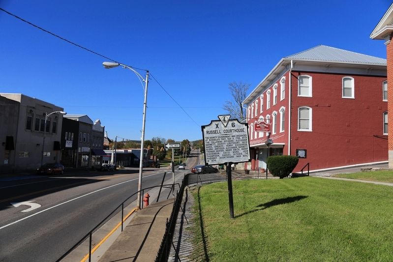 The county governmetn was organized at Russell’s Fort, May 9, 1786, with the following officers: Alexander Barnett, County Lieutenant; David Ward, Sheriff; Henry Dickenson, Clerk. Justices: Henry Smith, Henry Dickenson, David Ward, John Thompson, Samuel Ritchie. The present courthouse was built in 1874.
 To give gold-seekers another route to California, Capt. Randolph B. Marcy and Lt. James H. Simpson opened a wagon road from Arkansas to New Mexico in 1849. Marcy’s Road, although very popular with the Forty-Niners, still was never as well-traveled as the Santa Fe Trail. Here the route parallels I-40 to Albuquerque.
 Grassy plains meet pine dotted uplands in this transition from Great Plains to Basin and Range provinces. Plains to the east are capped by caliche, sand, and gravel which are deeply eroded into the underlying bedrock in places. To the west, faulting has produced alternating highlands and intermountain basins of the Basin and Range province. Elevation 6,500 feet.
 Near this site is the grave of Frances Dickenson
Scott Johnson (died 1796), sister of Henry
Dickenson who was the first clerk of Russell
County. In 1785, while living in Powell’s Valley
in Scott County, her first husband, Archibald
Scott, and their four children were murdered
by Indians, and she was taken captive. She
ultimately escaped, and after wandering in
the rugged mountains of Kentucky for nearly
a month, made her way back to Russell County.
She later married Thomas Johnson.
Near this site is the grave of Frances Dickenson
Scott Johnson (died 1796), sister of Henry
Dickenson who was the first clerk of Russell
County. In 1785, while living in Powell’s Valley
in Scott County, her first husband, Archibald
Scott, and their four children were murdered
by Indians, and she was taken captive. She
ultimately escaped, and after wandering in
the rugged mountains of Kentucky for nearly
a month, made her way back to Russell County.
She later married Thomas Johnson.


